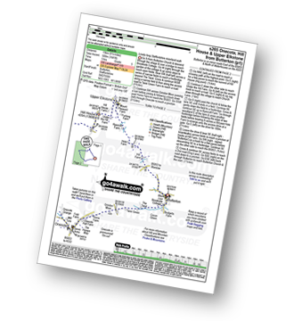
Six easy to follow pub walks from The Black Lion, Butterton, The Peak District, Staffordshire, England
To reach The Black Lion, Butterton, in-car SatNav users should select the Latitude/Longitude (Lat Lon) screen and enter:
Lat = N53.10615 and Lon = W 1.88895
Tap/mouse over a coloured circle (1-3 easy walks, 4-6 moderate walks, 7-9 hard walks) and click to select.
Tap/mouse over a coloured circle (1-3 easy walks, 4-6 moderate walks, 7-9 hard walks) and click to select.
Six easy to follow pub walks from The Black Lion, Butterton, The Peak District, Staffordshire, England
Scroll down the list of walks below & click on each walk title (in blue) to locate it on the map above.
   |
Vital Statistics:
| Length: | 7 miles (10.5 km) |
| Ascent: | 787ft (240m) |
| Time: | 3.25hrs |
| Grade: |  |
Route Summary:
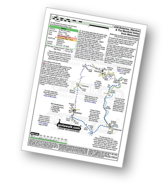
Wettonmill - Hoo Brook - Butterton - Warslow - Dale Bridge - Ecton - The Manifold Way - The River Manifold - Manifold Valley - Wettonmill
|
Vital Statistics:
| Length: | 7.75 miles (12.5 km) |
| Ascent: | 1,139ft (347m) |
| Time: | 4 hrs |
| Grade: |  |
Route Summary:
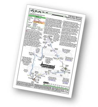
Onecote - Hamps Way - Onecote Grange - The River Hamps - Mixon Mines - Black Brook Farm - Breech Farm - Under The Hill Farm - Upper Elkstone - Ryecroft Farm - Hole Farm - Hill Farm - Butterton - The Twist - Grindon Moor (Grindon Moor) - Home Farm - Onecote
|
Vital Statistics:
| Length: | 8.5 miles (13.5 km) |
| Ascent: | 1,523ft (464m) |
| Time: | 4.75hrs |
| Grade: | |
Route Summary:
Butterton - Revidge - Cuckoostones - Reaps Moor - Blake Brook - Little Fernyfold Farm - Herbage Barn - Lum Edge - Upper Elkstone - Ryecroft Farm - Hole Farm - Hill Farm - Butterton
|
Vital Statistics:
| Length: | 8.75 miles (14 km) |
| Ascent: | 1,690ft (515m) |
| Time: | 5 hrs |
| Grade: | |
Route Summary:
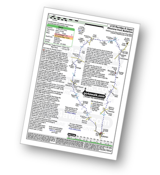
Butterton - Grindon Moor (Grindon Moor) - Ford - Ryebrook Farm - Grindon - Weag's Bridge - The Manifold Way - The River Manifold - Thor's Cave - Ladyside Wood - Dafar Bridge - Wettonmill - Hoo Brook - Butterton
|
Vital Statistics:
| Length: | 9.5 miles (15 km) |
| Ascent: | 1,641ft (500m) |
| Time: | 5 hrs |
| Grade: | |
Route Summary:
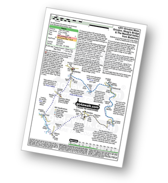
Butterton - Hoo Brook - The Twist - Grindon Moor - Onecote - Waterhouse - Old Mixon Hey Farm - Manor Farm - Hill House - Under The Hill Farm - Upper Elkstone - Ryecroft Farm - Hole Farm - Hill Farm - Butterton
|
Vital Statistics:
| Length: | 9.5 miles (15 km) |
| Ascent: | 1,483ft (452m) |
| Time: | 5 hrs |
| Grade: |  |
Route Summary:
Warslow - Villa Farm - Clayton House - Wallacre - Hoo Brook - Butterton - The Twist - Grindon Moor (Grindon Moor) - Onecote - Butterton Moor End Farm - Butterton Moor - Golden Hill - Black Brook Farm - Breech Farm - Underhill Farm - Upper Elkstone - Moorside - Cowhay Head - Warslow


