8 easy-to-follow walk, route maps of all grades on OS Explorer Map 259 Derby, Uttoxeter, Ashbourne & Cheadle
Eight easy-to-follow walk, route maps of all grades on OS Explorer Map 259 Derby, Uttoxeter, Ashbourne & Cheadle in Walk Grade OrderTap/mouse over a coloured circle (1-3 easy walks, 4-6 moderate walks, 7-9 hard walks) and click to select.
You can use these checkboxes to show only the grades of walk you are interested in:-
Eight easy-to-follow walk, route maps of all grades on OS Explorer Map 259 Derby, Uttoxeter, Ashbourne & Cheadle in Walk Grade Order
Scroll down the list of walks below & click on each walk title (in blue) to locate it on the map above.
See this list of walks, routes & maps in:
Grade Order | Length Order | Time Order | Walk Number or Start Location Order
NB. To reverse (toggle) this order, click Grade Order again
   |
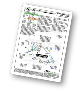
Vital Statistics:
| Length: | 6.75 miles (11 km) |
| Ascent: | 876ft (267m) |
| Time: | 3½ hrs |
| Grade: |  |
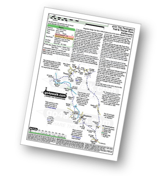
Route Summary:
Mappleton Lane (Ashbourne) - The Tissington Trail - Thorpe - The Limestone Way - Coldwall Bridge - River Dove - Big Peg's Wood - Little Peg's Wood - Littlepark Farm - Mappleton (aka Mapleton) - Callow Top - Mappleton Lane (Ashbourne)
|
Vital Statistics:
| Length: | 12.25 miles (19.5 km) |
| Ascent: | 1,930ft (588m) |
| Time: | 6½ hrs |
| Grade: |  |
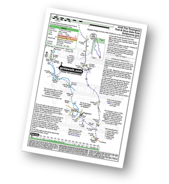
Route Summary:
Mappleton Lane (Ashbourne) - The Tissington Trail - Thorpe - Pike House - Bostern Grange Farm - Hanson Grange - The Nabs - Dove Dale - Dove Holes - Taylors Wood - Pickering Rock - Ilam Rock - Shaplow Dale - Lin Dale - Thorpe Cloud - Thorpe Mill Farm - The Limestone Way - Coldwall Bridge - River Dove - Big Peg's Wood - Little Peg's Wood - Littlepark Farm - Mappleton (aka Mapleton) - Callow Top - Mappleton Lane (Ashbourne)
|
Vital Statistics:
| Length: | 4.75 miles (7.5 km) |
| Ascent: | 742ft (226m) |
| Time: | 2½ hrs |
| Grade: |  |
Route Summary:
Ipstones - Booth's Hall Farm - Cherryeye Bridge - Caldon Canal - The Staffordshire Way - Podmores Bridge - Booth's Wood - Consall New Lock - Crowgutter Wood - Churnet Valley Railway - Consall Forge - River Churnet - Devil's Staircase - Belmont Hall - Noonsun Common - Ipstones
|
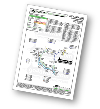
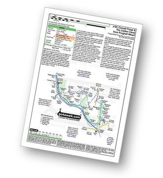
Vital Statistics:
| Length: | 4 miles (6.5 km) |
| Ascent: | 830ft (253m) |
| Time: | 2.25hrs |
| Grade: | |
Route Summary:
Froghall Wharf - Moseymoor Wood - Whieldon's Wood - Cloughead Wood - Blackbank Brook - Foxt - Newfields Gallery - Shirley Hollow - Oldridge Pinnacle - Harston Wood - Oldridge - Froghall Wharf
|
Vital Statistics:
| Length: | 4.75 miles (7.5 km) |
| Ascent: | 754ft (230m) |
| Time: | 2½ hrs |
| Grade: | |
Route Summary:
Ilam - Ilam Country Park - River Manifold - Lower Dove Dale - Upper Musden - Hazelton Clump - Blore - Coldwall Farm - The Limestone Way - Coldwall Bridge - The Manifold Trail - River Dove - Fishpond Wood - River Manifold - Ilam
|
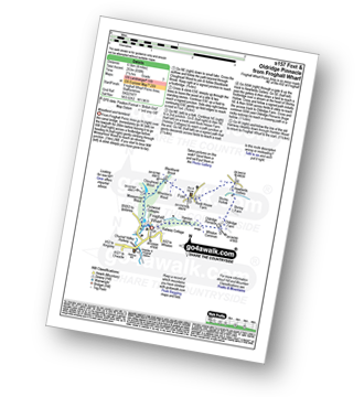
Vital Statistics:
| Length: | 6 miles (9.5 km) |
| Ascent: | 860ft (262m) |
| Time: | 3 hrs |
| Grade: | |
Route Summary:
Froghall Wharf - Moseymoor Wood - Ipstones - New House Wood - Booth's Farm - Booth's Hall Farm - Glenwood House - Crowgutter Wood - Caldon Canal - The Staffordshire Way - Consall Forge - Churnet Valley Railway - Consall New Lock - Booth's Wood - Podmores Bridge - Cherryeye Bridge - Ruelow Wood - Froghall - Froghall Wharf
|
Vital Statistics:
| Length: | 6 miles (9.5 km) |
| Ascent: | 918ft (280m) |
| Time: | 3.25hrs |
| Grade: | |
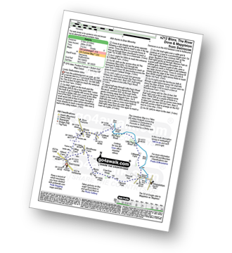
Route Summary:
Swinscoe - Hillend Farm - Feenie Lee - Blore - The Limestone Way - Coldwall Bridge - River Dove - Big Peg's Wood - Little Peg's Wood - Littlepark Farm - Mappleton (aka Mapleton) - Okeover Hall - Okeover Park - Cowclose Wood - Martin Hill - Woodhouse Farm - Swinscoe
|
Vital Statistics:
| Length: | 6.5 miles (10.5 km) |
| Ascent: | 745ft (227m) |
| Time: | 3.25hrs |
| Grade: | |
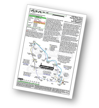
Route Summary:
Mappleton (aka Mapleton) - Okeover Bridge - Okeover Hall - Okeover Park - Cowclose Wood - Martin Hill Farm - Woodhouses Farm - Blore - Blore Pastures - Ilam - River Manifold - The Manifold Trail - Fishpond Wood - River Dove - Coldwall Bridge - Big Peg's Wood - Little Peg's Wood - Littlepark Farm - Okeover Bridge - Mappleton (aka Mapleton)
See this list of walks, routes & maps in:
Grade Order | Length Order | Time Order | Walk Number or Start Location Order
NB. To reverse (toggle) this order, click Grade Order again


