8 easy-to-follow walk, route maps of all grades on OS Explorer Map 107 St Austell & Liskeard
Eight easy-to-follow walk, route maps of all grades on OS Explorer Map 107 St Austell & Liskeard in Walk Grade OrderTap/mouse over a coloured circle (1-3 easy walks, 4-6 moderate walks, 7-9 hard walks) and click to select.
You can use these checkboxes to show only the grades of walk you are interested in:-
Eight easy-to-follow walk, route maps of all grades on OS Explorer Map 107 St Austell & Liskeard in Walk Grade Order
Scroll down the list of walks below & click on each walk title (in blue) to locate it on the map above.
See this list of walks, routes & maps in:
Grade Order | Length Order | Time Order | Walk Number or Start Location Order
NB. To reverse (toggle) this order, click Grade Order again
   |
Vital Statistics:
| Length: | 6 miles (9.5 km) |
| Ascent: | 1,076ft (328m) |
| Time: | 3.25hrs |
| Grade: |  |
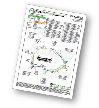
Route Summary:
Pelynt - Outways Farm - Tregarrick Mill - Muchlarnick - Yearle's Wood - West Looe River - Sowden's Bridge - Trelawne Mill - Kiln Wood - Cathrinepark Wood - Pelynt
|
Vital Statistics:
| Length: | 5.25 miles (8.5 km) |
| Ascent: | 1,260ft (384m) |
| Time: | 3.25hrs |
| Grade: | |
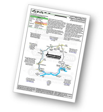
Route Summary:
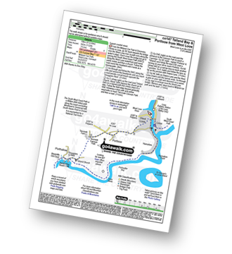
Crumplehorn - Longcoombe Mill - Watergate House - Sclerder Abbey - Porthallow - Talland Bay - The South West Coast Path - Downend Point - Polperro - Crumplehorn
|
Vital Statistics:
| Length: | 7.5 miles (12 km) |
| Ascent: | 1,533ft (467m) |
| Time: | 4.25hrs |
| Grade: |  |
Route Summary:
Millpool Car Park - West Looe - East Looe - The South West Coast Path - Hannafore Point - Portnadler Bay - Hore Stone - Talland Bay - Talland Church - Tencreek Campsite - Parkers Cross - Kilminorth - Watergate - West Looe River - Kilminorth Wood - West Looe - East Looe.
|
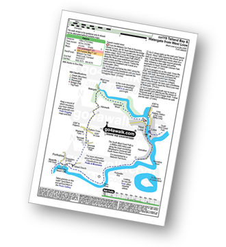
Vital Statistics:
| Length: | 3.75 miles (6 km) |
| Ascent: | 630ft (192m) |
| Time: | 2 hrs |
| Grade: |  |
Route Summary:
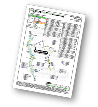
Duloe - Duloe Stone Circle - Gillhill Wood - West Looe River - Tremadart Wood - Churchbridge - Duloe
|
Vital Statistics:
| Length: | 8 miles (12 km) |
| Ascent: | 1,759ft (536m) |
| Time: | 4½ hrs |
| Grade: | |
Route Summary:
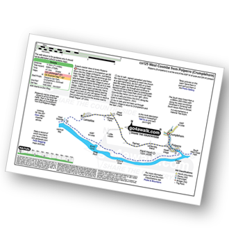
Crumplehorn - Polperro - Landaviddy Manor - Raphael - Great Tregue - Lansallos - West Coombe - The South West Coast Path - East Coombe - Broad Cove - Shag Rock - Colours Cove - Chapel Cliff - Polperro - Crumplehorn
|
Vital Statistics:
| Length: | 5.5 miles (9 km) |
| Ascent: | 1,407ft (448m) |
| Time: | 3½ hrs |
| Grade: | |
Route Summary:
Crumplehorn - Polperro - Landaviddy Manor - Raphael - Little Lizzen - East Coombe - The South West Coast Path - East Coombe - Broad Cove - Shag Rock - Colours Cove - Chapel Cliff - Polperro - Crumplehorn
|
Vital Statistics:
| Length: | 6.25 miles (10 km) |
| Ascent: | 1,122ft (342m) |
| Time: | 3½ hrs |
| Grade: | |
Route Summary:
Millpool Car Park - West Looe - East Looe - The South West Coast Path - Hannafore Point - Portnadler Bay - Hore Stone - Talland Bay - Talland Church - Tencreek Campsite - Portlooe - West Looe - East Looe.
|
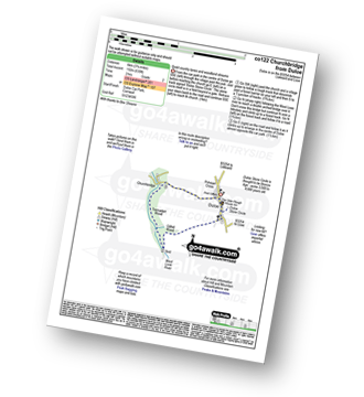
Vital Statistics:
| Length: | 7.25 miles (11.5 km) |
| Ascent: | 1,119ft (341m) |
| Time: | 3.75hrs |
| Grade: | |
Route Summary:
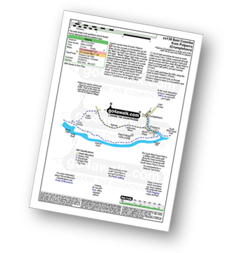
Duloe - Duloe Stone Circle - Gillhill Wood - West Looe River - Tremadart Wood - Churchbridge - Pendruffle Wood - Herodsfoot - Carglonnon Farm - Black Down - Bodbrane Farm - Polvean Cross - Duloe
See this list of walks, routes & maps in:
Grade Order | Length Order | Time Order | Walk Number or Start Location Order
NB. To reverse (toggle) this order, click Grade Order again


