Walks Routes Maps from A82 in Loch Leven to Connel Bridge, Strath of Orchy and Glen Lochy, Highland in Walk Grade Order
Route maps for Walks that start, or go through, A82 in Loch Leven to Connel Bridge, Strath of Orchy and Glen Lochy, Highland, Scotland in Walk Grade Order
Details of refreshments, pubs & parking are included on each A82 walk description.
   |
Vital Statistics:
| Length: | 9 miles (14.5 km) |
| Ascent: | 3,502ft (1,067m) |
| Time: | 6.75hrs |
| Grade: |  |
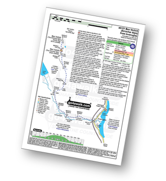
Route Summary:
Inveruglas Power Station - Loch Lomond - A82 - Inveruglas Water - Loch Sloy Access Road - Lag Dubh - Ben Vorlich (The Arrochar Alps) - Ben Vorlich (The Arrochar Alps) (North Top) - Lag Dubh - Loch Sloy Access Road - Inveruglas - Loch Lomond.
|
Vital Statistics:
| Length: | 8.25 miles (13 km) |
| Ascent: | 3,814ft (1,162m) |
| Time: | 7 hrs |
| Grade: | |
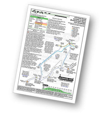
Route Summary:
The Pass of Glencoe - A82 - Altnafeadh - Lagangarbh Cottage - Allt Coire na Tulaich - Coire na Tulaich - Buachaille Etive Mor (Stob Dearg) - Feadan Ban (Buachaille Etive Mor) - Stob na Doire (Buachaille Etive Mor) - Stob Coire Altruim (Buachaille Etive Mor) - Stob na Broige (Buachaille Etive Mor) - Lairig Gartain - A82 The Pass of Glencoe.
|
Vital Statistics:
| Length: | 7.75 miles (12.5 km) |
| Ascent: | 4,391ft (1,338m) |
| Time: | 7.25hrs |
| Grade: | |
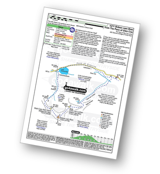
Route Summary:
The Pass of Glencoe - Coire Nan Lochan - Stob Coire Nan Lochan (Bidean Nam Bian) - Bidean Nam Bian - Stob Coire Nam Beith (Bidean Nam Bian) - Allt Coire Nam Beithach - A82 - Loch Achtriochtan - The Pass of Glencoe
|
Vital Statistics:
| Length: | 12.25 miles (19.5 km) |
| Ascent: | 4,322ft (1,317m) |
| Time: | 8.75hrs |
| Grade: |  |
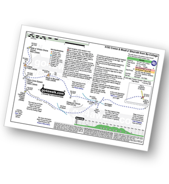
Route Summary:
A82 - Lochan na Stainge - Ba Cottage - Sron Nam Forsair - Clach Leathad (Creise) - Mam Coire Easain (Creise) - Creise - Stob a' Ghlais Choire (Creise) - Meall a' Bhuiridh - Ba Cottage - Lochan na Stainge - A82
See more easy-to-follow circular walks in Highland


