
![]()
Hare Stones
627m (2057ft)
The Northern Fells, The Lake District, Cumbria, England
Tap/mouse over a coloured circle (1-3 easy walks, 4-6 moderate walks, 7-9 hard walks) and click to select.
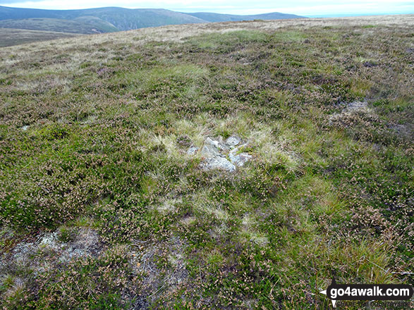
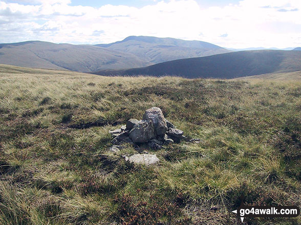
The summit of Hare Stones is marked by a small cairn.
Not familiar with this top?
Location
Hare Stones is a small, often overlooked summit nestled within the Calbeck Fells, part of the scenic Northern Fells range, located approximately 8 miles northeast of Keswick. Its minor top is situated close to Drygill Head, lying 50 meters northwest of The Cumbria Way trail as it winds between High Pike (Caldbeck) and the Lingy Hut bothy. A clear, level, grassy path leads directly to the small summit cairn. While perhaps not worth a significant detour for the casual walker, the location offers a quiet and secluded spot—perfect for a peaceful break and a sandwich.
The view
From the summit of Hare Stones, the vistas are excellent. Key surrounding fells visible include High Pike (Caldbeck) to the north-northeast (NNE), Carrock Fell to the east-southeast (ESE), Knott in the Uldale Fells to the southwest (SW), and Great Calvato the south-southwest (SSW).
Local History
The remnants of the Hare Stones Umber Mine can be found approximately 500 meters northwest of the summit. This area boasts a long history of mineral extraction, with mining for lead, copper, and barytes beginning as early as the 13th century. Activity reached its peak during the 17th century, though the final chapter of this industrial history closed when the last mine in the vicinity shut down in the 1960s.
   |
|---|
Vital Statistics:
| Length: | 7.75ml (12.5km) |
|---|---|
| Ascent: | 2,198ft (670m) |
| Time: | 5 hrs |
| Grade: |  (Moderate) (Moderate) |
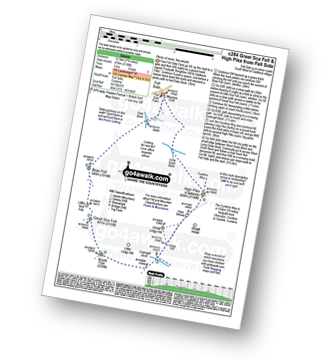
Route Summary:
Fell Side - Dale Beck - Brae Fell - Little Sca Fell - Great Sca Fell - Knott (Uldale Fells) - Grainsgill Beck - The Cumbria Way - Lingy Hut - Miller Moss - Great Lingy Hill - Hare Stones - High Pike (Caldbeck) - Long Grain Beck - Fell Side
|
|---|
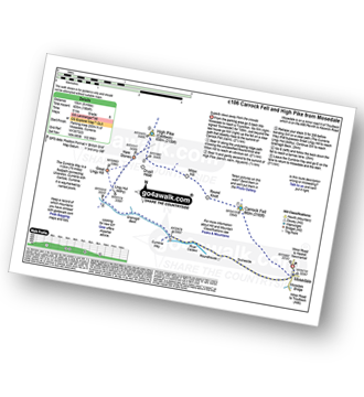
Vital Statistics:
| Length: | 9.5ml (15km) |
|---|---|
| Ascent: | 2,140ft (652m) |
| Time: | 5½ hrs |
| Grade: | (Moderate) |
Route Summary:
Stone Ends Farm - Apronful of Stones - Rake Trod - Further Gill Sike - Scurth - The Trough - Carrock Fell - Round Knott (Caldbeck) - Miton Hill (Caldbeck) - Red Gate (Track) - High Pike (Caldbeck) - Hare Stones - Great Lingy Hill - Miller Moss - Lingy Hut - Grainsgill Beck - The Cumbria Way - River Caldew - Swineside - Mosedale (Mungrisdale) - Stone Ends Farm
|
|---|
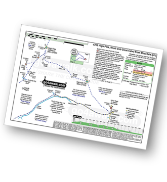
Vital Statistics:
| Length: | 14ml (22.5km) |
|---|---|
| Ascent: | 2,978ft (908m) |
| Time: | 8.25hrs |
| Grade: |  (Hard) (Hard) |
Route Summary:
Stone Ends Farm - Apronful of Stones - Rake Trod - Further Gill Sike - Scurth - The Trough - Carrock Fell - Round Knott (Caldbeck) - Miton Hill (Caldbeck) - Red Gate (Track) - High Pike (Caldbeck) - Hare Stones - Great Lingy Hill - Miller Moss - Lingy Hut - Grainsgill Beck - Knott (Uldale Fells) - Litle Calva - Great Calva - The Cumbria Way - Wiley Beck - River Caldew - Burdell - Gill - Wet Swine Gill - Grainsgill Beck - Swineside - Mosedale (Mungrisdale) - Stone Ends Farm
See Hare Stones and the surrounding tops on our free-to-access 'Google Style' Peak Bagging Maps:
The Northern Fells of The Lake District National Park
Less data - quicker to download
The Whole of The Lake District National Park
More data - might take a little longer to download
See Hare Stones and the surrounding tops on our downloadable Peak Bagging Maps in PDF format:

NB: Whether you print off a copy or download it to your phone, these PDF Peak Baggers' Maps might prove incredibly useful when your are up there on the tops and you cannot get a phone signal.
*This version is marked with the walk routes you need to follow to Walk all 214 Wainwrights in just 59 walks.
You can find Hare Stones & all the walks that climb it on these unique free-to-access Interactive Walk Planning Maps:
1:25,000 scale OS Explorer Map (orange/yellow covers):
1:50,000 scale OS Landranger Map (pink/magenta covers):
 Fellow go4awalkers who have already walked, climbed, summited & bagged Hare Stones
Richard Holmes walked up Hare Stones on September 3rd, 2023 [from/via/route] Mosedale [with] Myself. [weather] Very hot, good breeze in places. - Dangerous decent from Carrock Fell
Paul Macey climbed Hare Stones on July 17th, 2023 [from/via/route] Using walk c200 in reverse as couldn't find start! [weather] A dry day more sun than cloud about 16 degrees
Kevin Foster bagged Hare Stones on October 8th, 2020 [from/via/route] High Pike. [with] Henry. [weather] Sunny, clouding over later. - A flat moor top cresting the rise to the right of the main miners track leading out of Mosedale marked with a few big stones. Dreary! Move on!
Christine Shepherd hiked Hare Stones on July 23rd, 2008 [from/via/route] Walked from Mosedale using walk c200 [with] On my own [weather] Warm & a bit humid - Although I did this walk on my own I did meet a lovely lady on High Pike & walked with her as far as Lingy Hut. She was in her 70s & still leading walks. In fact she was doing a recce when I met her. Climbed again 1.9.18
Darren Mortimer summited Hare Stones on April 14th, 2018 [from/via/route] Mosedale [with] Dermot Palmer
Mark Davidson conquered Hare Stones on August 31st, 2004 [with] Mike [weather] Lovely & sunny
Ray O'hara scaled Hare Stones on February 24th, 2014 [from/via/route] Mosedale/Carrock Fell/High Pike/Knott/Great Calva/Mosedale [weather] Rained a fair bit, but no mist. Ground very boggy in places
Iain Taylor walked up Hare Stones on August 4th, 2010 [from/via/route] Nr Mosedale (NY 33069 32615)
Matthew Thomas has walked, climbed & bagged Hare Stones.
To add (or remove) your name and experiences on this page - Log On and edit your Personal Mountain Bagging Record
More Photographs & Pictures of views from, on or of Hare Stones
Send us your photographs and pictures on, of, or from Hare Stones
If you would like to add your walk photographs and pictures featuring views from, on or of Hare Stones to this page, please send them as email attachments (configured for any computer) along with your name to:
and we shall do our best to publish them.
(Guide Resolution = 300dpi. At least = 660pixels (wide) x 440 pixels (high).)

You can also submit photos via our Facebook Page.
NB. Please indicate where each photo was taken and whether you wish us to credit your photos with a Username or your First Name/Last Name.
Not familiar with this top?


