
![]()
Beinn a' Bhuiridh
897m (2944ft)
The Cruachan and Glen Lochy Hills, Loch Leven to Connel Bridge, Strath of Orchy and Glen Lochy, Argyll and Bute, Scotland
Tap/mouse over a coloured circle (1-3 easy walks, 4-6 moderate walks, 7-9 hard walks) and click to select.
Beinn a' Bhuiridh means 'Hill of Roaring Stags' .

Not familiar with this top?
   |
|---|
Vital Statistics:
| Length: | 11.5ml (18.5km) |
|---|---|
| Ascent: | 7,020ft (2,139m) |
| Time: | 11½ hrs |
| Grade: |  (Very Hard) (Very Hard) |
Route Summary:
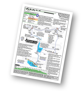
Falls of Cruachan - Loch Awe - Cruachan Reservoir - Coire Dearg - Meall Cuanail - Stob Dearg (Taynuilt Peak) - Ben Cruachan - Coire Caorach - Drochaid Ghlas (Ben Cruachan) - Stob Diamh - Stob Garbh (Stob Diamh) - Lairig Torran - Beinn a' Bhuiridh - Cruachan Reservoir - Falls of Cruachan
See Beinn a' Bhuiridh and the surrounding tops on our free-to-access 'Google Style' Peak Bagging Maps:
The Cruachan and Glen Lochy Hills area of Scottish Region 3: Loch Leven to Connel Bridge, Strath of Orchy and Glen Lochy
Less data - quicker to download
Scottish Region 3: Loch Leven to Connel Bridge, Strath of Orchy and Glen Lochy
Less data - quicker to download
See Beinn a' Bhuiridh and the surrounding tops on our downloadable Peak Bagging Map in PDF format:

NB: Whether you print off a copy or download it to your phone, this PDF Peak Baggers' Map might prove incredibly useful when your are up there on the tops and you cannot get a phone signal.
You can find Beinn a' Bhuiridh & all the walks that climb it on these unique free-to-access Interactive Walk Planning Maps:
1:25,000 scale OS Explorer Map (orange/yellow covers):
1:50,000 scale OS Landranger Map (pink/magenta covers):
 Fellow go4awalkers who have already walked, climbed, summited & bagged Beinn a' Bhuiridh
Mark Davidson walked up Beinn a' Bhuiridh on May 23rd, 2012 [with] Alone [weather] Warm & sunny - The final top on the Ben Cruachan Horseshoe at the end of a very long & tiring day. Loved every moment of it!
Trevor Williams has walked, climbed & bagged Beinn a' Bhuiridh.
To add (or remove) your name and experiences on this page - Log On and edit your Personal Mountain Bagging Record
Send us your photographs and pictures on, of, or from Beinn a' Bhuiridh
If you would like to add your walk photographs and pictures featuring views from, on or of Beinn a' Bhuiridh to this page, please send them as email attachments (configured for any computer) along with your name to:
and we shall do our best to publish them.
(Guide Resolution = 300dpi. At least = 660pixels (wide) x 440 pixels (high).)

You can also submit photos via our Facebook Page.
NB. Please indicate where each photo was taken and whether you wish us to credit your photos with a Username or your First Name/Last Name.
Not familiar with this top?


