
![]()
Moelwyn Mawr (North Ridge Top)
646m (2120ft)
The Moelwyns, Snowdonia, Gwynedd, Wales
Tap/mouse over a coloured circle (1-3 easy walks, 4-6 moderate walks, 7-9 hard walks) and click to select.
Moelwyn Mawr (North Ridge Top) means 'Big White Bare Hill' in Welsh.
Moelwyn Mawr (North Ridge Top) lost it's status as a 'Nuttall' in August 2015 due to insufficient prominence.
Not familiar with this top?
   |
|---|
Vital Statistics:
| Length: | 6.20ml (10.5km) |
|---|---|
| Ascent: | 2,691ft (820m) |
| Time: | 5 hrs |
| Grade: |  (Moderate) (Moderate) |
Route Summary:
Tanygrisiau - Moel-yr-hydd - Rhosydd Quarry - Moelwyn Mawr (North Ridge Top) - Moelwyn Mawr - Craigysgafn - Bwlch Stwlan - Moelwyn Bach - Llyn Stwlan - Stwlan Dam - Tanygrisiau
|
|---|
Vital Statistics:
| Length: | 8.25ml (13km) |
|---|---|
| Ascent: | 3,037ft (926m) |
| Time: | 6 hrs |
| Grade: | (Moderate) |
Route Summary:
Croesor - Rhosydd Quarry - Bwlch y Rhosydd - Clogwyn Brith - Moel-yr-hydd - Moelwyn Mawr (North Ridge Top) - Moelwyn Mawr - Craigysgafn - Bwlch Stwlan - Moelwyn Bach - Croesor
|
|---|
Vital Statistics:
| Length: | 9ml (14.5km) |
|---|---|
| Ascent: | 3,355ft (1,023m) |
| Time: | 6.75hrs |
| Grade: |  (Hard) (Hard) |
Route Summary:
Croesor - Croesor Bach - Cnicht - Cnicht (North Top) - Llyn Yr Adar - Afon Cwm-y-foel - Llyn Cwm-corsiog - Clogwyn Birth - Rhosydd Quarry - Moel-yr-hydd - Moelwyn Mawr (North Ridge Top) - Moelwyn Mawr - Croesor
|
|---|
Vital Statistics:
| Length: | 10ml (16km) |
|---|---|
| Ascent: | 3,923ft (1,196m) |
| Time: | 7½ hrs |
| Grade: | (Hard) |
Route Summary:
Croesor - Croesor Bach - Cnicht - Cnicht (North Top) - Llyn Yr Adar - Afon Cwm-y-foel - Llyn Cwm-corsiog - Clogwyn Birth - Rhosydd Quarry - Moel-yr-hydd - Moelwyn Mawr (North Ridge Top) - Moelwyn Mawr - Craigysgafn - Bwlch Stwlan - Moelwyn Bach - Croesor
See Moelwyn Mawr (North Ridge Top) and the surrounding tops on our free-to-access 'Google Style' Peak Bagging Maps:
The Moelwyns area of Snowdonia National Park
Less data - quicker to download
The Whole of Snowdonia National Park
More data - might take a little longer to download
See Moelwyn Mawr (North Ridge Top) and the surrounding tops on our downloadable Peak Bagging Map in PDF format:

NB: Whether you print off a copy or download it to your phone, this PDF Peak Baggers' Map might prove incredibly useful when your are up there on the tops and you cannot get a phone signal.
You can find Moelwyn Mawr (North Ridge Top) & all the walks that climb it on these unique free-to-access Interactive Walk Planning Maps:
1:25,000 scale OS Explorer Map (orange/yellow covers):
1:50,000 scale OS Landranger Map (pink/magenta covers):
 Fellow go4awalkers who have already walked, climbed, summited & bagged Moelwyn Mawr (North Ridge Top)
Christina Lander walked up Moelwyn Mawr (North Ridge Top) on April 18th, 2018 [from/via/route] Croesor - Cnicht - Bwlch y Rhosydd - Llyn Croesor - Moelwyn Mawr - Moelwyn Bach - Croesor [with] Dick [weather] Started off overcast, but turned into a beautiful sunny day. Windy on top of Moelwyn Mawr & Moelwyn Bach
Mark Davidson climbed Moelwyn Mawr (North Ridge Top) on August 20th, 2002 [with] Alone [weather] Sunny & warm with good views
Robert Taylor-Marriott bagged Moelwyn Mawr (North Ridge Top) on May 8th, 2013 [from/via/route] Route 51: Moel yr Hydd. Moelwyn Mawr NRT.Moelwyn Mawr. Craigysgafn. Moelwyn Bach (MMMB). [with] Vince Wetton and Robert Taylor-Marriott. [weather] Very Fair.
Gerald Murphy hiked Moelwyn Mawr (North Ridge Top) on March 29th, 2012 [from/via/route] See details of Moelwyn Mawr walk same day.
To add (or remove) your name and experiences on this page - Log On and edit your Personal Mountain Bagging Record
More Photographs & Pictures of views from, on or of Moelwyn Mawr (North Ridge Top)
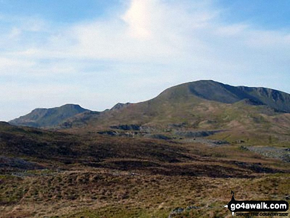
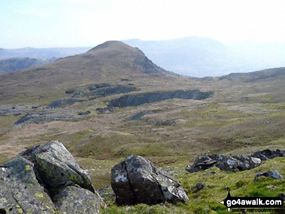
Moelwyn Bach, Bwlch Stwlan, Craigysgafn, Moelwyn Mawr and Moelwyn Mawr (North Ridge Top) (far right) from the col below Moel-yr-hydd
Send us your photographs and pictures on, of, or from Moelwyn Mawr (North Ridge Top)
If you would like to add your walk photographs and pictures featuring views from, on or of Moelwyn Mawr (North Ridge Top) to this page, please send them as email attachments (configured for any computer) along with your name to:
and we shall do our best to publish them.
(Guide Resolution = 300dpi. At least = 660pixels (wide) x 440 pixels (high).)

You can also submit photos via our Facebook Page.
NB. Please indicate where each photo was taken and whether you wish us to credit your photos with a Username or your First Name/Last Name.
Not familiar with this top?


