
![]()
Allt Lwyd
654m (2146ft)
The Brecon Beacons Area, The Brecon Beacons, Powys, Wales
Tap/mouse over a coloured circle (1-3 easy walks, 4-6 moderate walks, 7-9 hard walks) and click to select.
Allt Lwyd means 'Grey Hill' in Welsh and is pronounced 'athlt luid'.
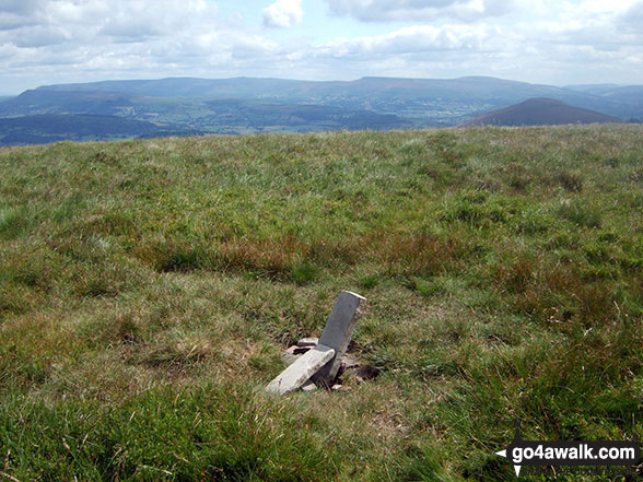
The summit of Allt Lwyd is marked by a small cairn.
Not familiar with this top?
   |
|---|
Vital Statistics:
| Length: | 7.75ml (12.5km) |
|---|---|
| Ascent: | 2,445ft (745m) |
| Time: | 5.25hrs |
| Grade: |  (Moderate) (Moderate) |
Route Summary:
Talybont Reservoir - Allt Lwyd - Gwalciau'r Cwm - Nant Cynafon - Cwar y Gigfran - Gwaun Cerrig Llwydion (Bwlch y Ddwyallt) - Waun Rydd - Craig Pwllfa - Carn Pica - Twyn Du (Waun Rydd) - Berth Lwyd Fach - Nant Tarthwynni - Talybont Reservoir
|
|---|
Vital Statistics:
| Length: | 10ml (16km) |
|---|---|
| Ascent: | 2,521ft (768m) |
| Time: | 6.25hrs |
| Grade: | (Moderate) |
Route Summary:
Talybont Reservoir - Allt Lwyd - Gwalciau'r Cwm - Carn Pica - Craig Pwllfa - Waun Rydd - Gwaun Cerrig Llwydion (Bwlch y Ddwyallt) - Rhiw Bwlch y Ddwyallt - Gist Wen - Ffordd Las or Bwlch Main - Bryn (Waun Rydd) - Bryn Bair - The Usk Valley Walk - Aber Village - Talybont Reservoir
|
|---|
Vital Statistics:
| Length: | 13.25ml (21km) |
|---|---|
| Ascent: | 3,397ft (1,035m) |
| Time: | 8.25hrs |
| Grade: |  (Hard) (Hard) |
Route Summary:
Talybont Reservoir - Allt Lwyd - Gwalciau'r Cwm - Carn Pica - Craig Pwllfa - Waun Rydd - Gwaun Cerrig Llwydion (Bwlch y Ddwyallt) - Graig Fan Las - Craig y Fan Ddu - Blaen y Glyn - The Taff Trail - Pant y Creigiau - Cefn Tarenni Cochion - Bryniau Gleision (Talybont Reservoir) - Darren Fawr - Darren Fach - Pen Bwlch Glasgwm - Pen Rhiw-calch - The Taff Trail - Talybont Reservoir
See Allt Lwyd and the surrounding tops on our free-to-access 'Google Style' Peak Bagging Maps:
The Brecon Beacons Area of Bannau Brycheiniog (The Brecon Beacons National Park)
Less data - quicker to download
The Whole of Bannau Brycheiniog (The Brecon Beacons National Park)
More data - might take a little longer to download
See Allt Lwyd and the surrounding tops on our downloadable Peak Bagging Map in PDF format:

NB: Whether you print off a copy or download it to your phone, this PDF Peak Baggers' Map might prove incredibly useful when your are up there on the tops and you cannot get a phone signal.
You can find Allt Lwyd & all the walks that climb it on these unique free-to-access Interactive Walk Planning Maps:
1:25,000 scale OS Explorer Map (orange/yellow covers):
1:50,000 scale OS Landranger Map (pink/magenta covers):
 Fellow go4awalkers who have already walked, climbed, summited & bagged Allt Lwyd
Nikola Jenkins walked up Allt Lwyd on May 3rd, 2025 [from/via/route] Aber village [with] April Bryant and Charlotte [weather] Hot, still lower down but windy at the ridge - got sunburt
Christina Lander climbed Allt Lwyd on October 2nd, 2022 [from/via/route] Carn Pica from Talybont Reservoir [with] Dick [weather] Sunny day
Mark Davidson bagged Allt Lwyd on July 10th, 2009 [from/via/route] Walk po152 Allt Lwyd, Waun Rydd & Bryn from Talybont Reservoir [with] MK (Well for some of it!) [weather] Quite nice
Sion Britton hiked Allt Lwyd on April 17th, 2021 [with] Solo [weather] Braf
Kimberley Gratton summited Allt Lwyd on July 23rd, 2019 [from/via/route] I started off from Talybont Reservoir, going up NW on a signed track all the way to Allt Lwyd (this was VERY steep!) From there I went via the Cam Pica stone built beacon towards Waun Rydd, & then Gwaun Cerrig Lwydion. Finally heading to Bryn (Waun Rydd) & down back to Talybont Reservoir. [weather] Hot & Sunny - The path from Bryn back to Talybont Reservoir wasn't clear & not as pleasant as the rest of the walk. I would suggest going back the way you came.
Robert Taylor-Marriott conquered Allt Lwyd on December 5th, 2012 [from/via/route] Route 46: Bwlch y Ddwyallt, Waun Rydd & Allt Lwyd (BWA) Completed 05.12.12 + [with] Vince Wetton and Robert Taylor-Marriott. [weather] Sunny, snow & cold.
Syd Barnes scaled Allt Lwyd on February 18th, 2014 [from/via/route] Talybont car park [with] Alone [weather] Sunny
Richard Penney walked up Allt Lwyd on October 7th, 2012 [from/via/route] Talybont - Steep steep steep
Elen Newcombe-ling, Paul Roddam, Michael Rygol and Matthew Thomas have all walked, climbed & bagged Allt Lwyd.
To add (or remove) your name and experiences on this page - Log On and edit your Personal Mountain Bagging Record
Send us your photographs and pictures on, of, or from Allt Lwyd
If you would like to add your walk photographs and pictures featuring views from, on or of Allt Lwyd to this page, please send them as email attachments (configured for any computer) along with your name to:
and we shall do our best to publish them.
(Guide Resolution = 300dpi. At least = 660pixels (wide) x 440 pixels (high).)

You can also submit photos via our Facebook Page.
NB. Please indicate where each photo was taken and whether you wish us to credit your photos with a Username or your First Name/Last Name.
Not familiar with this top?


