
![]()
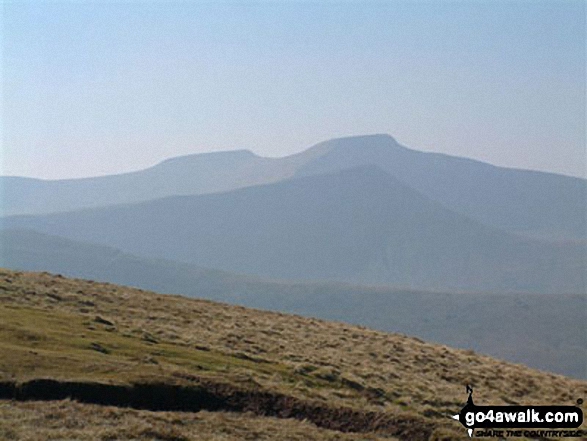
Gwaun Cerrig Llwydion (Bwlch y Ddwyallt)
754m (2475ft)
The Brecon Beacons Area, The Brecon Beacons, Powys, Wales
Gwaun Cerrig Llwydion (Bwlch y Ddwyallt) means 'Gray Stone Heath (Pass with Two Hills)' in Welsh and is pronounced 'g-wine kerrig thlu-dion (bulch uh thui-athlt)'.
The summit of Gwaun Cerrig Llwydion (Bwlch y Ddwyallt) is marked by a large flat cairn.
Not familiar with this top?
You can walk/hike to the top of Gwaun Cerrig Llwydion (Bwlch y Ddwyallt) by using any of these 5 easy‑to‑follow route maps:
Walk po126 Allt Lwyd and Waun Rydd from Talybont Reservoir
Steady ascent to good views
   |
|---|
Vital Statistics:
| Length: | 7.75ml (12.5km) |
|---|---|
| Ascent: | 2,445ft (745m) |
| Time: | 5.25hrs |
| Grade: |  (Moderate) (Moderate) |
Route Summary:
Talybont Reservoir - Allt Lwyd - Gwalciau'r Cwm - Nant Cynafon - Cwar y Gigfran - Gwaun Cerrig Llwydion (Bwlch y Ddwyallt) - Waun Rydd - Craig Pwllfa - Carn Pica - Twyn Du (Waun Rydd) - Berth Lwyd Fach - Nant Tarthwynni - Talybont Reservoir
Walk po131 Bwlch y Ddwyallt and Fan y Big from Blaen y Glyn
The finest ridge walk in the Brecon Beacons
|
|---|
Vital Statistics:
| Length: | 8.25ml (13km) |
|---|---|
| Ascent: | 1,942ft (592m) |
| Time: | 5 hrs |
| Grade: | (Moderate) |

Route Summary:
Blaen y Glyn - Craig y Fan Ddu - Gwaun Cerrig Llwydion (Bwlch y Ddwyallt) - Craig Cwareli - Craig Cwmoergwm - Fan y Big - Bwlch ar y Fan - Roman Road - The Taff Trail - Blaen y Glyn
Walk po119 Waun Rydd and Bryn from Talybont Reservoir
Steady ascent to good views
|
|---|
Vital Statistics:
| Length: | 9ml (14.5km) |
|---|---|
| Ascent: | 2,330ft (710m) |
| Time: | 5½ hrs |
| Grade: | (Moderate) |
Route Summary:
Talybont Reservoir - Twyn Du (Waun Rydd) - Carn Pica - Craig Pwllfa - Waun Rydd - Gwaun Cerrig Llwydion (Bwlch y Ddwyallt) - Rhiw Bwlch y Ddwyallt - Gist Wen - Ffordd Las or Bwlch Main - Bryn (Waun Rydd) - Bryn Bair - The Usk Valley Walk - Aber Village - Talybont Reservoir
Walk po152 Allt Lwyd, Waun Rydd and Bryn from Talybont Reservoir
Steady ascent to fabulous views
|
|---|
Vital Statistics:
| Length: | 10ml (16km) |
|---|---|
| Ascent: | 2,521ft (768m) |
| Time: | 6.25hrs |
| Grade: | (Moderate) |
Route Summary:
Talybont Reservoir - Allt Lwyd - Gwalciau'r Cwm - Carn Pica - Craig Pwllfa - Waun Rydd - Gwaun Cerrig Llwydion (Bwlch y Ddwyallt) - Rhiw Bwlch y Ddwyallt - Gist Wen - Ffordd Las or Bwlch Main - Bryn (Waun Rydd) - Bryn Bair - The Usk Valley Walk - Aber Village - Talybont Reservoir
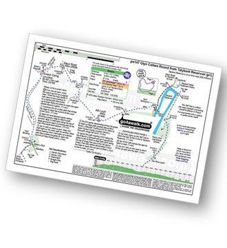
Walk po147 The Glen Collwn Round from Talybont Reservoir
Long high level walk with dramatic views.
|
|---|
Vital Statistics:
| Length: | 13.25ml (21km) |
|---|---|
| Ascent: | 3,397ft (1,035m) |
| Time: | 8.25hrs |
| Grade: |  (Hard) (Hard) |
Route Summary:
Talybont Reservoir - Allt Lwyd - Gwalciau'r Cwm - Carn Pica - Craig Pwllfa - Waun Rydd - Gwaun Cerrig Llwydion (Bwlch y Ddwyallt) - Graig Fan Las - Craig y Fan Ddu - Blaen y Glyn - The Taff Trail - Pant y Creigiau - Cefn Tarenni Cochion - Bryniau Gleision (Talybont Reservoir) - Darren Fawr - Darren Fach - Pen Bwlch Glasgwm - Pen Rhiw-calch - The Taff Trail - Talybont Reservoir
See Gwaun Cerrig Llwydion (Bwlch y Ddwyallt) and the surrounding tops on our free-to-access 'Google Style' Peak Bagging Maps:
The Brecon Beacons Area of Bannau Brycheiniog (The Brecon Beacons National Park)
Less data - quicker to download
The Whole of Bannau Brycheiniog (The Brecon Beacons National Park)
More data - might take a little longer to download
See Gwaun Cerrig Llwydion (Bwlch y Ddwyallt) and the surrounding tops on our unique, downloadable, PDF Peak Bagging Map:

NB: Whether you print off a copy or download it to your phone, this PDF Peak Baggers' Map might prove incredibly useful when your are up there on the tops and you cannot get a phone signal.
You can find Gwaun Cerrig Llwydion (Bwlch y Ddwyallt) & all the walks that climb it on these unique free-to-access Interactive Walk Planning Maps:
1:25,000 scale OS Explorer Map (orange/yellow covers):
1:50,000 scale OS Landranger Map (pink/magenta covers):
 Fellow go4awalkers who have already walked, climbed, scaled, summited, hiked & bagged Gwaun Cerrig Llwydion (Bwlch y Ddwyallt)
Stephanie Doyle walked up Gwaun Cerrig Llwydion (Bwlch y Ddwyallt) on December 2nd, 2025 [with] Friend [weather] Wet, & windy, bursts of sun - Great views
Nikola Jenkins climbed it on May 3rd, 2025 [from/via/route] Aber village [with] April Bryant and Charlotte [weather] Hot, still lower down but windy at the ridge - got sunburnt
Mark Davidson bagged it on July 10th, 2009 [from/via/route] Walk po152 Allt Lwyd, Waun Rydd & Bryn from Talybont Reservoir [with] MK (Well for some of it!) [weather] Quite nice
Sion Britton hiked Gwaun Cerrig Llwydion (Bwlch y Ddwyallt) on December 12th, 2020 [from/via/route] Fan y Big o Blaen y Glyn Uchaf. [with] Rhiannon [weather] Showers & Cool.
Kimberley Gratton summited on July 23rd, 2019 [from/via/route] I started off from Talybont Reservoir, going up NW on a signed track all the way to Allt Lwyd (this was VERY steep!) From there I went via the Cam Pica stone built beacon towards Waun Rydd, & then Gwaun Cerrig Lwydion. Finally heading to Bryn (Waun Rydd) & down back to Talybont Reservoir. [weather] Hot & Sunny - The path from Bryn back to Talybont Reservoir wasn't clear & not as pleasant as the rest of the walk. I would suggest going back the way you came.
To add (or remove) your name and experiences on this page - Log On and edit your Personal Mountain Bagging Record
. . . [see more walk reports]
Send us your photographs and pictures on, of, or from Gwaun Cerrig Llwydion (Bwlch y Ddwyallt)
If you would like to add your walk photographs and pictures to this page, please send them as email attachments (configured for any computer) along with your name to:
and we shall do our best to publish them.
(Guide Resolution = 300dpi. At least = 660pixels (wide) x 440 pixels (high).)

You can also submit photos via our Facebook Page.
NB. Please indicate where each photo was taken and whether you wish us to credit your photos with a Username or your First Name/Last Name.


