Scottish Region 13: The Achnashellach and Torridon Hills - a fully detailed list of all the Mountains, Peaks, Tops and Hills (Page 2 of 2)
Scottish Region 13: The Achnashellach and Torridon Hills region is the area enclosed by an imaginary line connecting:
- Loch Ewe to Achnasheen via Loch Maree, Taagan, Kinlochewe and Loch a' Chroisg to the North East
- Achnasheen to Kyle of Lochalsh via the A890. Achnashellach Station, Glen Carron, Strathcarron, Loch Carron and Inner Sound to the South East
- Kyle of Lochalsh to Loch Ewe via Inner Sound the West
If you count only the Marilyns there are 38 tops to climb, bag & conquer and the highest point is Spidean a' Choire Leith (Liathach) at 1,055m (3,463ft).
To see these Mountains, Peaks, Tops and Hills displayed in different ways - see the options in the left-hand column and towards the bottom of this page.
LOG ON and RELOAD this page to show which Mountains, Peaks, Tops and Hills you have already climbed, bagged & conquered [. . . more details]
Page 2 of 2 Go to page: 1 2 |
See this list in: Alphabetical Order
| Height Order‡
To reverse the order select the link again.
Mountain, Peak, Top or Hill:
Bagged
31. Bidein Clann Raonaild
466m (1,529ft)
Send it in and we'll publish it here.
Bidein Clann Raonaild is on interactive maps:
A downloadable go4awalk.com PDF Peak Bagging Map featuring Bidein Clann Raonaild will be available soon. |
32. Seana Mheallan
437m (1,434ft)
Seana Mheallan is on interactive maps:
A downloadable go4awalk.com PDF Peak Bagging Map featuring Seana Mheallan will be available soon. |
33. Meall an Doirein
420m (1,378ft)
Meall an Doirein is on interactive maps:
A downloadable go4awalk.com PDF Peak Bagging Map featuring Meall an Doirein will be available soon. |
34. Meall Lochan a' Chleirich
403m (1,323ft)
Send it in and we'll publish it here.
Meall Lochan a' Chleirich is on interactive maps:
A downloadable go4awalk.com PDF Peak Bagging Map featuring Meall Lochan a' Chleirich will be available soon. |
35. Bad a' Chreamha
395m (1,296ft)
Bad a' Chreamha is on interactive maps:
A downloadable go4awalk.com PDF Peak Bagging Map featuring Bad a' Chreamha will be available soon. |
36. An Sgurr (Loch Kishorn)
392m (1,287ft)
Send it in and we'll publish it here.
An Sgurr (Loch Kishorn) is on interactive maps:
A downloadable go4awalk.com PDF Peak Bagging Map featuring An Sgurr (Loch Kishorn) will be available soon. |
37. Sithean Mor (Sidhean Mor) (Wester Ross)
383m (1,256ft)
Send it in and we'll publish it here.
Sithean Mor (Sidhean Mor) (Wester Ross) is on interactive maps:
A downloadable go4awalk.com PDF Peak Bagging Map featuring Sithean Mor (Sidhean Mor) (Wester Ross) will be available soon. |
38. An Cuaidh
296m (971ft)
An Cuaidh is on interactive maps:
A downloadable go4awalk.com PDF Peak Bagging Map featuring An Cuaidh will be available soon. |
Page 2 of 2 Go to page: 1 2 |
View these 38 Mountains, Peaks, Tops and Hills:
- On an Interactive Google Map (loads faster)
- On an Interactive Google Map with a list of tops below it.
(makes it easier to locate a particular top) - On a Detailed List in:
Alphabetical Order | Height Order - On one page with 'yet-to-be-bagged' listed 1st & then 'already-bagged' tops listed 2nd in:
Alphabetical Order | Height Order - On one page with 'already-bagged' tops listed 1st & then 'yet-to-be-bagged' tops listed 2nd in:
Alphabetical Order | Height Order
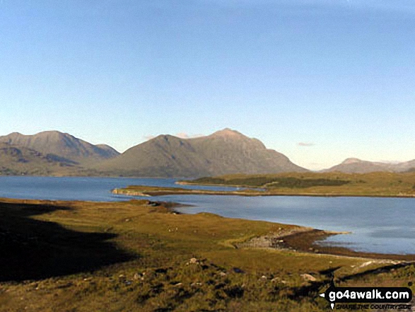
 Spidean a' Choire Leith (Liathach) in The Achnashellach and Torridon Hills
Photo: Lovat Fraser
Is there a Mountain, Peak, Top or Hill missing from the above google map or list?
Let us know an we will add it to our database.


