All the Mountains, Peaks, Tops and Hills in The Forest of Bowland and The South Pennines with all the tops you have already bagged first & then the ones you are yet to climb second
The Forest of Bowland and The South Pennines is located in North West England covering parts of Cumbria, Greater Manchester, Lancashire, Merseyside and West Yorkshire.
If you count only the Deweys there are 6 tops to climb, bag & conquer and the highest point is Mallowdale Pike (Mallowdale Fell) at 561m (1,841ft).
To see these Mountains, Peaks, Tops and Hills displayed in different ways - see the options in the left-hand column and towards the bottom of this page.
![]() Your Personal Bagging Record for The Forest of Bowland and The South Pennines
Your Personal Bagging Record for The Forest of Bowland and The South Pennines
LOG ON and RELOAD this page to show which Mountains, Peaks, Tops and Hills you have already climbed, bagged & conquered [. . . more details]
Scroll down this list of mountains, peaks, tops & hills below and tap/click on each name (in blue) to locate it on the map above.
See this list in: Alphabetical Order‡ | Height Order
To reverse the order select the link again.
Mountain, Peak, Top or Hill already bagged:
Bagged
Top yet to be climbed, bagged & conquered:
Bagged

![]()
1. Fair Snape Fell
520m (1706ft)
Dewey
See more details, photos, trip reports and easy-to-follow walks up Fair Snape Fell
![]()
2. Lad Law (Boulsworth Hill)
517m (1697ft)
Dewey
See more details, photos, trip reports and easy-to-follow walks up Lad Law (Boulsworth Hill)
![]()
3. Mallowdale Pike (Mallowdale Fell)
561m (1841ft)
Dewey
See more details, photos, trip reports and easy-to-follow walks up Mallowdale Pike (Mallowdale Fell)
![]()
4. Pendle Hill (Beacon or Big End)
557m (1828ft)
Dewey
See more details, photos, trip reports and easy-to-follow walks up Pendle Hill (Beacon or Big End)
![]()
5. White Hill (Forest of Bowland)
544m (1785ft)
Dewey
See more details, photos, trip reports and easy-to-follow walks up White Hill (Forest of Bowland)
![]()
6. Wolfhole Crag
528m (1733ft)
Dewey
See more details, photos, trip reports and easy-to-follow walks up Wolfhole Crag
![]() Your Personal Bagging Record for The Forest of Bowland and The South Pennines
Your Personal Bagging Record for The Forest of Bowland and The South Pennines
LOG ON and RELOAD this page to show which Mountains, Peaks, Tops and Hills you have already climbed, bagged & conquered [. . . more details]
View these 6 Mountains, Peaks, Tops and Hills:
- On a Downloadable PDF you can Print or Save to your Phone#
- On an Interactive Google Map (loads faster)
- On an Interactive Google Map with a list of tops below it.
(makes it easier to locate a particular top) - On a Detailed List in:
Alphabetical Order | Height Order - On one page with 'yet-to-be-bagged' listed 1st & then 'already-bagged' tops listed 2nd in:
Alphabetical Order | Height Order - On one page with 'already-bagged' tops listed 1st & then 'yet-to-be-bagged' tops listed 2nd in:
Alphabetical Order | Height Order
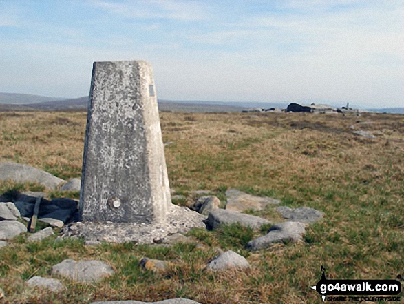 The summit of Mallowdale Pike (Mallowdale Fell) in The Forest of Bowland and The South Pennines
Photo: Des Ellwood
# Whether you print a copy or download it to your phone, this Peak Baggers' Map will prove incredibly useful if you want to know what's what when you are up in the mountains and cannot get a phone signal.
Is there a Mountain, Peak, Top or Hill missing from the above google map or list?


