All the Peaks, Tops and Hills in The Forest of Bowland and The South Pennines as a detailed list

The Forest of Bowland and The South Pennines is located in North West England covering parts of Cumbria, Greater Manchester, Lancashire, Merseyside and West Yorkshire.

If you count only the Marilyns there are 14 tops to climb, bag & conquer and the highest point is Mallowdale Pike (Mallowdale Fell) at 561m (1,841ft).

Wainwright
0/0
Wainwrights

hewitt
0/0
English
Mountains

Dewey
6/0
English
Deweys

nuttall
0/0
English
Nuttalls

Wainwright Outlying Fell
0/0
Wainwright
Outlying Fells

marilyn
14/0
English
Marilyns

Bridget
43/0
English
Bridgets

Trig Point
42/0
Trig
Points


To see all Mountains, Peaks, Tops and Hills displayed in different ways - see the options in the left-hand column and towards the bottom of this page.


LOG ON and RELOAD this page to show which Mountains, Peaks, Tops and Hills you have already climbed, bagged & conquered [. . . more]


See this list in: Alphabetical Order | Height Order
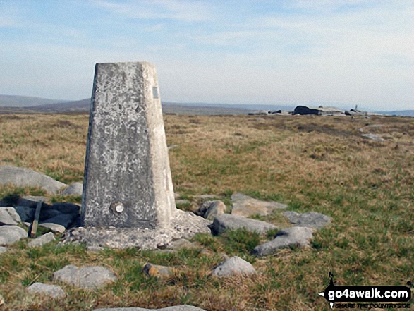
To reverse the order select the link again.


Mountain, Peak, Top or Hill:

Bagged


1. Mallowdale Pike (Mallowdale Fell)

561m (1,841ft)

  • Dewey (52nd in England, 120th in England & Wales)
  • Marilyn (58th in England, 845th in GB)
  • OS Trig Point

  • To walk, climb & bag Mallowdale Pike (Mallowdale Fell) use either of these easy to follow walks:

    Google Maps Icon
    See the location of Mallowdale Pike (Mallowdale Fell) and walks up it on a google Map

    Mallowdale Pike (Mallowdale Fell) is on interactive maps:

  • OS Explorer (Orange Covers): OL41
  • OS Landranger (Pink Covers): 102

  • Mallowdale Pike (Mallowdale Fell) is on Peak Bagging Map and Hill Tick List:


    2. Pendle Hill (Beacon or Big End)

    557m (1,828ft)

  • Dewey (58th in England, 134th in England & Wales)
  • Marilyn (60th in England, 854th in GB)
  • OS Trig Point

  • To walk, climb & bag Pendle Hill (Beacon or Big End) use any of these easy to follow walks:

    Google Maps Icon
    See the location of Pendle Hill (Beacon or Big End) and walks up it on a google Map

    Pendle Hill (Beacon or Big End) is on interactive maps:

  • OS Explorer (Orange Covers): OL21 and OL41
  • OS Landranger (Pink Covers): 103

  • Pendle Hill (Beacon or Big End) is on Peak Bagging Map and Hill Tick List:


    3. White Hill (Forest of Bowland)

    544m (1,785ft)

  • Dewey (84th in England, 195th in England & Wales)
  • Marilyn (65th in England, 891st in GB)
  • OS Trig Point

  • To walk, climb & bag White Hill (Forest of Bowland) use either of these easy to follow walks:

    Google Maps Icon
    See the location of White Hill (Forest of Bowland) and walks up it on a google Map

    White Hill (Forest of Bowland) is on interactive maps:

  • OS Explorer (Orange Covers): OL41
  • OS Landranger (Pink Covers): 103

  • White Hill (Forest of Bowland) is on Peak Bagging Map and Hill Tick List:


    4. Fair Snape Fell

    520m (1,706ft)

  • Dewey (138th in England, 317th in England & Wales)
  • Marilyn (70th in England, 937th in GB)

  • To walk, climb & bag Fair Snape Fell use any of these easy to follow walks:

    Google Maps Icon
    See the location of Fair Snape Fell and walks up it on a google Map

    Fair Snape Fell is on interactive maps:

  • OS Explorer (Orange Covers): OL41
  • OS Landranger (Pink Covers): 102

  • Fair Snape Fell is on Peak Bagging Map and Hill Tick List:


    5. Lad Law (Boulsworth Hill)

    517m (1,697ft)

  • Dewey (143rd in England, 331st in England & Wales)
  • Marilyn (73rd in England, 942nd in GB)
  • OS Trig Point

  • To walk, climb & bag Lad Law (Boulsworth Hill) use this easy to follow walk:

    Google Maps Icon
    See the location of Lad Law (Boulsworth Hill) and walks up it on a google Map

    Lad Law (Boulsworth Hill) is on interactive maps:

  • OS Explorer (Orange Covers): OL21
  • OS Landranger (Pink Covers): 103

  • Lad Law (Boulsworth Hill) is on Peak Bagging Map and Hill Tick List:


    6. Hail Storm Hill

    477m (1,566ft)

  • Marilyn (82nd in England, 1035th in GB)

  • To walk, climb & bag Hail Storm Hill use any of these easy to follow walks:

    Google Maps Icon
    See the location of Hail Storm Hill and walks up it on a google Map

    Hail Storm Hill is on interactive maps:

  • OS Explorer (Orange Covers): OL21
  • OS Landranger (Pink Covers): 109

  • Hail Storm Hill is on Peak Bagging Map and Hill Tick List:


    7. Winter Hill (Rivington Moor)

    456m (1,497ft)

  • Marilyn (85th in England, 1093rd in GB)
  • OS Trig Point

  • To walk, climb & bag Winter Hill (Rivington Moor) use either of these easy to follow walks:

    Google Maps Icon
    See the location of Winter Hill (Rivington Moor) and walks up it on a google Map

    Winter Hill (Rivington Moor) is on interactive maps:

  • OS Explorer (Orange Covers): 287
  • OS Landranger (Pink Covers): 109

  • Winter Hill (Rivington Moor) is on Peak Bagging Map and Hill Tick List:


    8. Freeholds Top

    455m (1,493ft)

  • Marilyn (86th in England, 1095th in GB)
  • OS Trig Point

  • We hope to have walks that climb & bag Freeholds Top very soon

    Google Maps Icon
    See the location of Freeholds Top and walks up it on a google Map

    Freeholds Top is on interactive maps:

  • OS Explorer (Orange Covers): OL21
  • OS Landranger (Pink Covers): 103

  • Freeholds Top is on Peak Bagging Map and Hill Tick List:


    9. Rombalds Moor (Ilkley Moor)

    402m (1,319ft)

  • Marilyn (97th in England, 1203rd in GB)
  • OS Trig Point

  • To walk, climb & bag Rombalds Moor (Ilkley Moor) use either of these easy to follow walks:

    Google Maps Icon
    See the location of Rombalds Moor (Ilkley Moor) and walks up it on a google Map

    Rombalds Moor (Ilkley Moor) is on interactive maps:

  • OS Explorer (Orange Covers): 297
  • OS Landranger (Pink Covers): 104

  • Rombalds Moor (Ilkley Moor) is on Peak Bagging Map and Hill Tick List:


    10. Easington Fell

    396m (1,300ft)

  • Marilyn (98th in England, 1213th in GB)

  • To walk, climb & bag Easington Fell use this easy to follow walk:

    Google Maps Icon
    See the location of Easington Fell and walks up it on a google Map

    Easington Fell is on interactive maps:

  • OS Explorer (Orange Covers): OL41
  • OS Landranger (Pink Covers): 103

  • Easington Fell is on Peak Bagging Map and Hill Tick List:


    11. Longridge Fell (Spire Hill)

    350m (1,149ft)

  • Marilyn (109th in England, 1299th in GB)
  • OS Trig Point

  • To walk, climb & bag Longridge Fell (Spire Hill) use this easy to follow walk:

    Google Maps Icon
    See the location of Longridge Fell (Spire Hill) and walks up it on a google Map

    Longridge Fell (Spire Hill) is on interactive maps:

  • OS Explorer (Orange Covers): OL41
  • OS Landranger (Pink Covers): 102 and 103

  • Longridge Fell (Spire Hill) is on Peak Bagging Map and Hill Tick List:


    12. Hutton Roof Crags

    274m (899ft)

  • Marilyn (144th in England, 1427th in GB)
  • OS Trig Point

  • We hope to have walks that climb & bag Hutton Roof Crags very soon

    Google Maps Icon
    See the location of Hutton Roof Crags and walks up it on a google Map

    Hutton Roof Crags is on interactive maps:

  • OS Explorer (Orange Covers): OL7
  • OS Landranger (Pink Covers): 97

  • Hutton Roof Crags is on Peak Bagging Map and Hill Tick List:


    13. Billinge Hill

    179m (587ft)

  • Marilyn (172nd in England, 1540th in GB)
  • OS Trig Point
  • Billinge Hill is the highest point in the county of Merseyside.


    To walk, climb & bag Billinge Hill use this easy to follow walk:

    Google Maps Icon
    See the location of Billinge Hill and walks up it on a google Map

    Billinge Hill is on interactive maps:

  • OS Explorer (Orange Covers): 285
  • OS Landranger (Pink Covers): 108

  • Billinge Hill is on Peak Bagging Map and Hill Tick List:


    14. Arnside Knott

    159m (522ft)

  • Marilyn (175th in England, 1554th in GB)
  • OS Trig Point

  • To walk, climb & bag Arnside Knott use this easy to follow walk:

    Google Maps Icon
    See the location of Arnside Knott and walks up it on a google Map

    Arnside Knott is on interactive maps:

  • OS Explorer (Orange Covers): OL7
  • OS Landranger (Pink Covers): 97

  • Arnside Knott is on Peak Bagging Map and Hill Tick List:


    View all 60 Mountains, Peaks, Tops and Hills in The Forest of Bowland and The South Pennines:

    # Whether you print a copy or download it to your phone, this Peak Baggers' Map will prove incredibly useful if you want to know what's what when you are up in the mountains and cannot get a phone signal


    Is there a Mountain, Peak, Top or Hill missing from the above google map or list?

    Let us know an we will add it to our database.


    Do not miss our pick of the Best Walks in Britain


    Follow go4awalk.com on Twitter Follow go4awalk.com on Facebook


    Home


    Find new Friends to go walking with

    Walk all 214 Wainwrights in just 59 Walks. Download GPS Waypoints - Great Walks you must not miss!

    Walk The Yorkshire Three Peaks Challenge Walk - All the Latest Route Information, GPS Waypoints and Split Times to keep you on Schedule

    Walk The British Three Peaks Challenge Walk - All the Latest Route Information and GPS Waypoints

    See our pick of The Best Walks in The Lake District - Great Walks you must not miss!

    Walk our pick of the Best Lake District Ridge Walks - Great Walks you must not miss!

    Walk our pick of the Best Lake District Walks to do in the rain - Great Walks you must not miss!

    Walk our pick of The Best Walks in Snowdonia - Great Walks you must not miss!

    Walk our pick of The Best Ridge Walks in Wales - Walks you must not miss!

    Walk our pick of The Best Walks in The Brecon Beacons - Great Walks you must not miss!

    Walk our pick of The Best Walks in The Yorkshire Dales - Walks you must not miss!

    Walk our pick of The Best Walks in The Peak District - Walks you must not miss!

    Walk our pick of The Best Walks in The Forest of Bowland - Walks you must not miss!

    Walk our pick of The Best Walks in Shropshire - Walks you must not miss!

    Walk our pick of The Best Walks in Cheshire - Walks you must not miss!

    Walk our pick of The Best Walks in Lancashire - Walks you must not miss!

    Not sure where to walk next? Try Peak Bagging - Great Walks you must not miss!

    Not sure where to walk next? Walk part of a National Trail - Great Walks you must not miss!

    Walks with Downloadable and Uploadable GPS Waypoint Data

    Walking Kit and Gear Tested by Walkers

    Full Site Search