Mynyddoedd Cambria (The Cambrian Mountains) - a fully detailed list of all the Mountains, Peaks, Tops and Hills (Page 1 of 3)
Mynyddoedd Cambria (The Cambrian Mountains) is located in Central Wales covering parts of Ceredigion, Powys and Carmarthenshire.
If you count only the Deweys there are 82 tops to climb, bag & conquer and the highest point is Y Gamriw at 604m (1,982ft).
To see these Mountains, Peaks, Tops and Hills displayed in different ways - see the options in the left-hand column and towards the bottom of this page.
![]() Your Personal Bagging Record for Mynyddoedd Cambria (The Cambrian Mountains)
Your Personal Bagging Record for Mynyddoedd Cambria (The Cambrian Mountains)
LOG ON and RELOAD this page to show which Mountains, Peaks, Tops and Hills you have already climbed, bagged & conquered [. . . more details]
See this list in: Alphabetical Order‡
| Height Order
To reverse the order select the link again.
Mountain, Peak, Top or Hill:
Bagged

![]()
1. Y Gamriw
604m (1,982ft)
Y Gamriw is on interactive maps:
Y Gamriw is on downloadable PDF you can Print or Save to your Phone: |
![]()
2. Y Foel (Pant Mawr)
546m (1,791ft)
Y Foel (Pant Mawr) is on interactive maps:
A downloadable go4awalk.com PDF Peak Bagging Map featuring Y Foel (Pant Mawr) will be available soon. |
![]()
3. Whimble
599m (1,965ft)
Whimble is on interactive maps:
A downloadable go4awalk.com PDF Peak Bagging Map featuring Whimble will be available soon. |
![]()
4. Warren Hill (Dildre Bank)
507m (1,663ft)
Send it in and we'll publish it here.
Warren Hill (Dildre Bank) is on interactive maps:
A downloadable go4awalk.com PDF Peak Bagging Map featuring Warren Hill (Dildre Bank) will be available soon. |
![]()
5. Stanky Hill
506m (1,660ft)
Stanky Hill is on interactive maps:
A downloadable go4awalk.com PDF Peak Bagging Map featuring Stanky Hill will be available soon. |
![]()
6. Red Hill (Rhulen)
509m (1,670ft)
Red Hill (Rhulen) is on interactive maps:
A downloadable go4awalk.com PDF Peak Bagging Map featuring Red Hill (Rhulen) will be available soon. |
![]()
7. Priddellau (Esgair Nantybeddau)
533m (1,749ft)
Send it in and we'll publish it here.
Priddellau (Esgair Nantybeddau) is on interactive maps:
A downloadable go4awalk.com PDF Peak Bagging Map featuring Priddellau (Esgair Nantybeddau) will be available soon. |
![]()
8. Pool Hill
516m (1,693ft)
Pool Hill is on interactive maps:
A downloadable go4awalk.com PDF Peak Bagging Map featuring Pool Hill will be available soon. |
![]()
9. Penrhiw-wen
510m (1,673ft)
Penrhiw-wen is on interactive maps:
A downloadable go4awalk.com PDF Peak Bagging Map featuring Penrhiw-wen will be available soon. |
![]()
10. Pen y Darren (Moel Hyddgen)
529m (1,736ft)
Send it in and we'll publish it here.
Pen y Darren (Moel Hyddgen) is on interactive maps:
A downloadable go4awalk.com PDF Peak Bagging Map featuring Pen y Darren (Moel Hyddgen) will be available soon. |
![]()
11. Pen Lan-fawr
526m (1,726ft)
Pen Lan-fawr is on interactive maps:
A downloadable go4awalk.com PDF Peak Bagging Map featuring Pen Lan-fawr will be available soon. |
![]()
12. Pen Dihewyd
513m (1,683ft)
Pen Dihewyd is on interactive maps:
A downloadable go4awalk.com PDF Peak Bagging Map featuring Pen Dihewyd will be available soon. |
![]()
13. Pen Creigiau'r Llan
507m (1,663ft)
Send it in and we'll publish it here.
Pen Creigiau'r Llan is on interactive maps:
A downloadable go4awalk.com PDF Peak Bagging Map featuring Pen Creigiau'r Llan will be available soon. |
![]()
14. Pegwn Mawr
586m (1,923ft)
Pegwn Mawr is on interactive maps:
A downloadable go4awalk.com PDF Peak Bagging Map featuring Pegwn Mawr will be available soon. |
![]()
15. Pant-llwyd
549m (1,801ft)
Pant-llwyd is on interactive maps:
A downloadable go4awalk.com PDF Peak Bagging Map featuring Pant-llwyd will be available soon. |
![]()
16. Nyth-grug
538m (1,765ft)
Nyth-grug is on interactive maps:
A downloadable go4awalk.com PDF Peak Bagging Map featuring Nyth-grug will be available soon. |
![]()
17. Mynydd Trawsnant
517m (1,696ft)
Mynydd Trawsnant is on interactive maps:
A downloadable go4awalk.com PDF Peak Bagging Map featuring Mynydd Trawsnant will be available soon. |
![]()
18. Mynydd Coch
569m (1,867ft)
Mynydd Coch is on interactive maps:
A downloadable go4awalk.com PDF Peak Bagging Map featuring Mynydd Coch will be available soon. |
![]()
19. Moelfryn (Cerrig Cochion)
522m (1,713ft)
Send it in and we'll publish it here.
Moelfryn (Cerrig Cochion) is on interactive maps:
A downloadable go4awalk.com PDF Peak Bagging Map featuring Moelfryn (Cerrig Cochion) will be available soon. |
![]()
20. Moel y Llyn (Cambrian Mountains)
521m (1,709ft)
Send it in and we'll publish it here.
Moel y Llyn (Cambrian Mountains) is on interactive maps:
A downloadable go4awalk.com PDF Peak Bagging Map featuring Moel y Llyn (Cambrian Mountains) will be available soon. |
![]()
21. Moel Hywel
505m (1,657ft)
Moel Hywel is on interactive maps:
A downloadable go4awalk.com PDF Peak Bagging Map featuring Moel Hywel will be available soon. |
![]()
22. Llyn Du (Mynydd Tywi) (East Top)
545m (1,788ft)
Send it in and we'll publish it here.
Llyn Du (Mynydd Tywi) (East Top) is on interactive maps:
A downloadable go4awalk.com PDF Peak Bagging Map featuring Llyn Du (Mynydd Tywi) (East Top) will be available soon. |
![]()
23. Llyn Du (Mynydd Tywi)
548m (1,798ft)
Send it in and we'll publish it here.
Llyn Du (Mynydd Tywi) is on interactive maps:
A downloadable go4awalk.com PDF Peak Bagging Map featuring Llyn Du (Mynydd Tywi) will be available soon. |
![]()
24. Llechwedd Hirgoed (South East Top)
535m (1,755ft)
Send it in and we'll publish it here.
Llechwedd Hirgoed (South East Top) is on interactive maps:
A downloadable go4awalk.com PDF Peak Bagging Map featuring Llechwedd Hirgoed (South East Top) will be available soon. |
![]()
25. Llechwedd Hirgoed
538m (1,765ft)
Llechwedd Hirgoed is on interactive maps:
A downloadable go4awalk.com PDF Peak Bagging Map featuring Llechwedd Hirgoed will be available soon. |
![]()
26. Llechwedd Ddu (Carnbwlchcloddiau)
559m (1,834ft)
Send it in and we'll publish it here.
Llechwedd Ddu (Carnbwlchcloddiau) is on interactive maps:
A downloadable go4awalk.com PDF Peak Bagging Map featuring Llechwedd Ddu (Carnbwlchcloddiau) will be available soon. |
![]()
27. Llanfihangel Hill (Colva Hill)
532m (1,746ft)
Send it in and we'll publish it here.
Llanfihangel Hill (Colva Hill) is on interactive maps:
A downloadable go4awalk.com PDF Peak Bagging Map featuring Llanfihangel Hill (Colva Hill) will be available soon. |
![]()
28. Llan Ddu Fawr (Waun Claerddu)
594m (1,949ft)
Send it in and we'll publish it here.
Llan Ddu Fawr (Waun Claerddu) is on interactive maps:
A downloadable go4awalk.com PDF Peak Bagging Map featuring Llan Ddu Fawr (Waun Claerddu) will be available soon. |
![]()
29. Gwaunceste Hill (Gwaun-Ceste Hill)
542m (1,778ft)
Send it in and we'll publish it here.
Gwaunceste Hill (Gwaun-Ceste Hill) is on interactive maps:
A downloadable go4awalk.com PDF Peak Bagging Map featuring Gwaunceste Hill (Gwaun-Ceste Hill) will be available soon. |
![]()
30. Gors Lydan
528m (1,732ft)
Gors Lydan is on interactive maps:
A downloadable go4awalk.com PDF Peak Bagging Map featuring Gors Lydan will be available soon. |
View these 82 Mountains, Peaks, Tops and Hills:
- On an Interactive Google Map (loads faster)
- On an Interactive Google Map with a list of tops below it.
(makes it easier to locate a particular top) - On a Detailed List in:
Alphabetical Order | Height Order - On one page with 'yet-to-be-bagged' listed 1st & then 'already-bagged' tops listed 2nd in:
Alphabetical Order | Height Order - On one page with 'already-bagged' tops listed 1st & then 'yet-to-be-bagged' tops listed 2nd in:
Alphabetical Order | Height Order
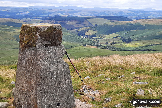
 Pen Pumlumon Fawr (Plynlimon) in The South Eastern Area of Mynyddoedd Cambria (The Cambrian Mountains)
Photo: Mike Matthews
Is there a Mountain, Peak, Top or Hill missing from the above google map or list?
Let us know an we will add it to our database.
To contribute to go4awalk.com or to contact us about anything at all - see Talk To Us.
For help see Help.
go4awalk.com and go4awalk.co.uk are registered trademarks of TMDH Limited.
Copyright © 2000-2025 TMDH Limited. All rights reserved.
Copyright Terms & Conditions Privacy Statement
A - Z Walks Home Log On/Accounts Photo Gallery Walk Ideas and Collections Fell Facts Hill Skills Walking Questions and Answers Your Stories News Competitions Product Reviews/Gear Tests Walking Gear Guides Peaks and Mountains Peak Bagging Find New Walking Friends Camping GPS Waypoints for Walking Contents Walk Search Talk To Us go4awalk.com Help Free Example Walks Newsletter


