One easy to follow pub walk from The Norfolk Arms, Steyning, The South Downs, West Sussex, England
To reach The Norfolk Arms, Steyning, in-car SatNav users should select the Latitude/Longitude (Lat Lon) screen and enter:
Lat = N50.88837 and Lon = W 0.32788
Tap/mouse over a coloured circle (1-3 easy walks, 4-6 moderate walks, 7-9 hard walks) and click to select.
Tap/mouse over a coloured circle (1-3 easy walks, 4-6 moderate walks, 7-9 hard walks) and click to select.
One easy to follow pub walk from The Norfolk Arms, Steyning, The South Downs, West Sussex, England
Scroll down the list of walks below & click on each walk title (in blue) to locate it on the map above.
   |
Vital Statistics:
| Length: | 3.75 miles (6 km) |
| Ascent: | 689ft (210m) |
| Time: | 2.25hrs |
| Grade: |  |
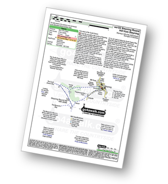
Route Summary:
Steyning - Spring Meadows Farm - The South Downs Way - Steyning Round Hill - The Monarch's Way - Pepperscoombe Farm - Steyning


