Three easy to follow pub walks from Ye Old Nags Head, Castleton, The Peak District, Derbyshire, England
To reach Ye Old Nags Head, Castleton, in-car SatNav users should select the Latitude/Longitude (Lat Lon) screen and enter:
Lat = N53.34313 and Lon = W 1.77568
Tap/mouse over a coloured circle (1-3 easy walks, 4-6 moderate walks, 7-9 hard walks) and click to select.
Tap/mouse over a coloured circle (1-3 easy walks, 4-6 moderate walks, 7-9 hard walks) and click to select.
Three easy to follow pub walks from Ye Old Nags Head, Castleton, The Peak District, Derbyshire, England
Scroll down the list of walks below & click on each walk title (in blue) to locate it on the map above.
   |
Vital Statistics:
| Length: | 9.5 miles (15 km) |
| Ascent: | 1,588ft (484m) |
| Time: | 5 hrs |
| Grade: |  |

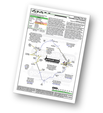
Route Summary:
Hope - Townhead Bridge - Losehill End - Lose Hill (Ward's Piece) - Back Tor (Hollins Cross) - Barker Bank - Hollins Cross - Mam Tor Farm - Knowlgate Farm - Odin Sitch - Castleton - Hollowford Centre - Spring House Farm - Hope
|
Vital Statistics:
| Length: | 6 miles (9.5 km) |
| Ascent: | 1,887ft (575m) |
| Time: | 4 hrs |
| Grade: | |
Route Summary:
Castleton - The Limestone Way - Peveril Castle - Cave Dale - Old Moor - Rowter Farm - Windy Knoll - Mam Tor - Hollins Cross - Backtor Nook - Castleton
|
Vital Statistics:
| Length: | 11.5 miles (18.5 km) |
| Ascent: | 2,001ft (610m) |
| Time: | 6 hrs |
| Grade: |  |
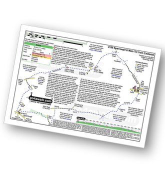
Route Summary:
Castleton - The Limestone Way - Cave Dale - Perry Dale - Sparrowpit - Rushup Farm - Rushup Hall - Rushup Edge - Lord's Seat (Rushup Edge) - Mam Tor - Hollins Cross - Backtor Nook - Castleton


