Nine easy to follow pub walks from The Black Bull, Coniston, The Lake District, Cumbria, England
To reach The Black Bull, Coniston, in-car SatNav users should select the Latitude/Longitude (Lat Lon) screen and enter:
Lat = N54.36934 and Lon = W 3.07602
Tap/mouse over a coloured circle (1-3 easy walks, 4-6 moderate walks, 7-9 hard walks) and click to select.
Tap/mouse over a coloured circle (1-3 easy walks, 4-6 moderate walks, 7-9 hard walks) and click to select.
Nine easy to follow pub walks from The Black Bull, Coniston, The Lake District, Cumbria, England
Scroll down the list of walks below & click on each walk title (in blue) to locate it on the map above.
   |
Vital Statistics:
| Length: | 7.75 miles (12.5 km) |
| Ascent: | 1,758ft (536m) |
| Time: | 4.75hrs |
| Grade: |  |
Route Summary:
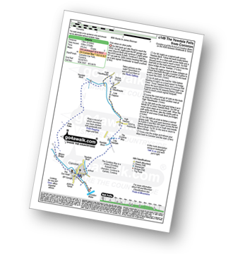
Coniston - The Cumbria Way - Low Yewdale - Yewdale Beck - High Yewdale - Yew Band - Low Tilberthwaite - High Tilberthwaite - Low Coppice - Tilberthwaite Gill - Crook Beck - Hole Rake - Miners Bridge - Church Beck - Coniston
|
Vital Statistics:
| Length: | 10 miles (16 km) |
| Ascent: | 1,364ft (416m) |
| Time: | 5 hrs |
| Grade: | |
Route Summary:
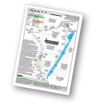
Coniston - Walna Scar Road - Banishead - Torver Beck - Torver - Beckstones - The Cumbria Way - Coniston Water - Coniston Sailing Club - Coniston Hall - Coniston
|
Vital Statistics:
| Length: | 5 miles (8 km) |
| Ascent: | 1,935ft (590m) |
| Time: | 4 hrs |
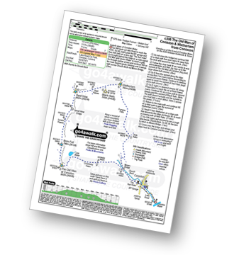
| Grade: | |
Route Summary:
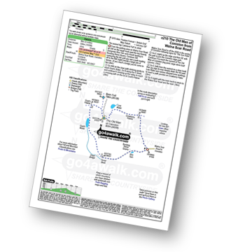
Coniston - Walna Scar Road - Goat's Water - The Old Man of Coniston - Low Water - Walna Scar Road - Coniston
|
Vital Statistics:
| Length: | 8.25 miles (13 km) |
| Ascent: | 2,778ft (847m) |
| Time: | 5.75hrs |
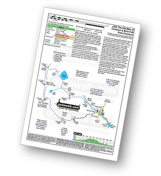
| Grade: |  |
Route Summary:
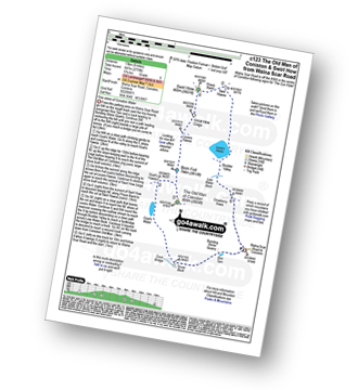
Coniston - Walna Scar Road - Goat's Water - The Old Man of Coniston - Brim Fell - Levers Hawse - Swirl Band - Swirl How - Prison Band - Levers Water - Walna Scar Road - Coniston
|
Vital Statistics:
| Length: | 7.5 miles (12 km) |
| Ascent: | 2,762ft (842m) |
| Time: | 5.25hrs |
| Grade: | |
Route Summary:
Coniston - Walna Scar Road - Boo Tarn - The Old Man of Coniston - Brim Fell - Levers Water - Boulder Valley - Crowberry Haws - Miners Bridge - Coniston
|
Vital Statistics:
| Length: | 9.5 miles (15 km) |
| Ascent: | 3,523ft (1,074m) |
| Time: | 7 hrs |
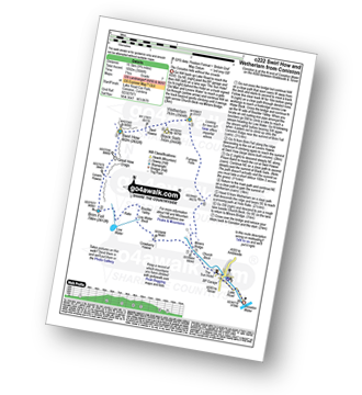
| Grade: |  |
Route Summary:
Walna Scar Road (nr Seathwaite (Duddon Valley) - Long Houses - Brown Pike - Dow Crag - Goat's Hawse - The Old Man of Coniston - Brim Fell - Levers Hawse - Swirl Band - Swirl How - Great Carrs - Grey Friar - Seathwaite Tarn - Walna Scar Road.
|
Vital Statistics:
| Length: | 10 miles (16 km) |
| Ascent: | 3,584ft (1,092m) |
| Time: | 7 hrs |
| Grade: | |
Route Summary:
Coniston - Church Beck - Levers Water Beck - Crowberry Haws - Low Water - Brim Fell - Levers Hawse - Swirl Band - Swirl How - Prison Band - Swirl Hawse - Keld Gill Head - Black Sails - Red Dell Head Moss - Wetherlam - Furness Fells - Coniston
|
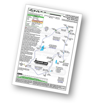
Vital Statistics:
| Length: | 9.75 miles (15.5 km) |
| Ascent: | 3,664ft (1,117m) |
| Time: | 7.25hrs |
| Grade: | |
Route Summary:
Coniston - Church Beck - Levers Water Beck - Crowberry Haws - Low Water - The Old Man of Coniston - Brim Fell - Levers Hawse - Swirl Band - Swirl How - Prison Band - Swirl Hawse - Keld Gill Head - Black Sails - Red Dell Head Moss - Wetherlam - Furness Fells - Coniston
|
Vital Statistics:
| Length: | 12.75 miles (20.5 km) |
| Ascent: | 4,191ft (1,277m) |
| Time: | 8.75hrs |
| Grade: |  |
Route Summary:
Coniston - Walna Scar Road - Boo Tarn - Torver Beck - Cove Bridge - Goat's Water - Goat's Hawse - Dow Crag - Goat's Hawse - The Old Man of Coniston - Brim Fell - Levers Hawse - Grey Friar - Great Carrs - Swirl How - Prison Band - Keld Gill Head - Black Sails - Wetherlam - Swirl Hawse - Levers Water - Crowberry Haws - Walna Scar Road - Coniston


