Ten easy to follow walks from Masons Farm Camp Site Campsite, Appletreewick, The Yorkshire Dales, North Yorkshire, England
To reach Masons Farm Camp Site Campsite, Appletreewick, in-car SatNav users should select the Latitude/Longitude (Lat Lon) screen and enter:
Lat = N54.03691 and Lon = W1.92156 or postcode: BD23 6DD
Tap/mouse over a coloured circle (1-3 easy walks, 4-6 moderate walks, 7-9 hard walks) and click to select.
Tap/mouse over a coloured circle (1-3 easy walks, 4-6 moderate walks, 7-9 hard walks) and click to select.
Ten easy to follow walks from Masons Farm Camp Site Campsite, Appletreewick, The Yorkshire Dales, North Yorkshire, England
Scroll down the list of walks below & click on each walk title (in blue) to locate it on the map above.
   |
Vital Statistics:
| Length: | 7.25 miles (11.5 km) |
| Ascent: | 210ft (64m) |
| Time: | 3 hrs |
| Grade: |  |
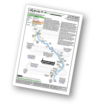
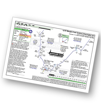
Route Summary:
Wharfedale - Bolton Abbey - The Dales Way - The River Wharfe - Wharfedale - Pickles Beck - Stead Dike - Posforth Gill - Black Sike - Bolton Abbey Aqueduct - Barden Bridge - Bolton Abbey Aqueduct - The Strid - Strid Wood - Cavendish Pavilion - Sand Holme - Bolton Priory - Bolton Abbey - Wharfedale
|
Vital Statistics:
| Length: | 3.5 miles (5.5 km) |
| Ascent: | 738ft (225m) |
| Time: | 2 hrs |
| Grade: |  |
|
Vital Statistics:
| Length: | 6.75 miles (11 km) |
| Ascent: | 607ft (185m) |
| Time: | 3.25hrs |
| Grade: | |
Route Summary:
Grassington - The Dales Way - Bank Lathe - Intake Lathe - Moor Lane - Hebden Beck - Loss Gill Bank - Cockbur Ford - Bolton Haw Side - The Mere - Rocking Stone - Care Scar,Hole Bottom - Scale Haw - Knowles Lathe - Side Lathe - High Green - Hebden - The River Wharfe - The Dales Way - Linton Falls - Grassington
|
Vital Statistics:
| Length: | 7.5 miles (12 km) |
| Ascent: | 876ft (267m) |
| Time: | 3½ hrs |
| Grade: |  |
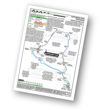
Route Summary:
Grassington - Kimpergill Hill - Downs Pasture - Green Hill Pasture - Seeds Hill - Kelber - Bycliffe Road (Track) - The Dales Way - Old Pasture - Lea Green - Grassington
|
Vital Statistics:
| Length: | 11.5 miles (18.5 km) |
| Ascent: | 1,017ft (310m) |
| Time: | 5.25hrs |
| Grade: |  |
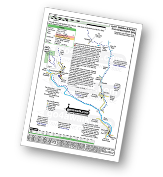
Route Summary:
Grassington - The Dales Way - Lea Green - Old Pasture - Bycliffe Road (Track) - Kelber Gate - Kelber - Seeds Hill - Green Hill Pasture - Downs Pasture - New Pasture Edge - Yarnbury - Hebden Beck - Loss Gill Bank - Cockbur Ford - Bolton Haw Side - The Mere - Rocking Stone - Care Scar,Hole Bottom - Scale Haw - Knowles Lathe - Side Lathe - High Green - Hebden - The River Wharfe - The Dales Way - Linton Falls - Grassington
|
Vital Statistics:
| Length: | 11 miles (17.5 km) |
| Ascent: | 1,181ft (360m) |
| Time: | 5.25hrs |
| Grade: | |
Route Summary:
Yarnbury - Grassington Lead Mines - Duke's New Road (Track) - Hebden Beck - Cupola Corner - Deep Cut - Grassington Moor - Rather Standard Side - Sleet Moor - Rather Standard End - Henstone Band - Meugher Dike - Meugher Drive - Meugher - Friar Hood - Sandy Gate - Sandy Gate Pike Shelter - Mossdale - Mossdale Shooting Lodge - Mossdale Beck - Mossdale Scar - Bycliffe Road (Track) - Bycliffe - Kelber - Seeds Hill - Green Hill Pasture - Back Pasture - Downs Pasture - High Barn (ruin) - New Pasture Edge - Yarnbury
|
Vital Statistics:
| Length: | 8.5 miles (13.5 km) |
| Ascent: | 1,158ft (353m) |
| Time: | 4.25hrs |
| Grade: | |
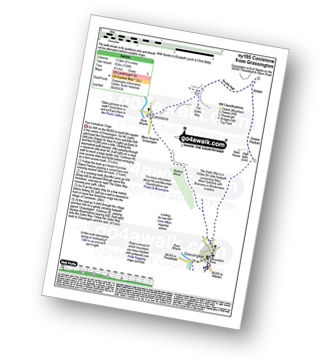
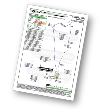
Route Summary:
Grassington - Kimpergill Hill - Downs Pasture - Green Hill Pasture - Seeds Hill - Kelber - Bycliffe Road (Track) - The Dales Way - Bull Scar - Davy Dimple - Conistone - Little Lathe - Dib Dale - Bastow Wood - The Dales Way - Grassington
|
Vital Statistics:
| Length: | 7.5 miles (12 km) |
| Ascent: | 1,492ft (455m) |
| Time: | 4½ hrs |
| Grade: | |
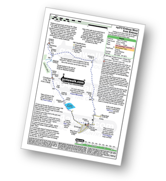
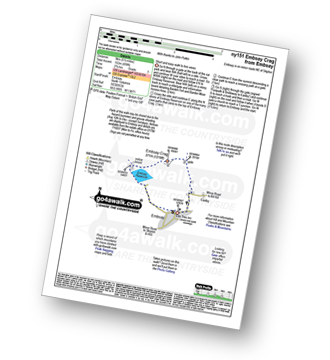
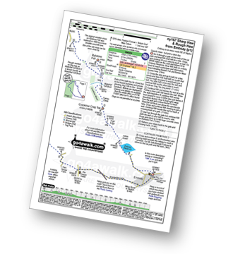
Route Summary:
Embsay - Embsay Reservoir - Embsay Moor - Crookrise Crag Top - Waterfall Gill Beck - Rylstone Fell - Rylstone Cross - Barden Moor - Embsay Moor - Embsay
|
Vital Statistics:
| Length: | 12 miles (19 km) |
| Ascent: | 2,099ft (640m) |
| Time: | 6½ hrs |
| Grade: |  |
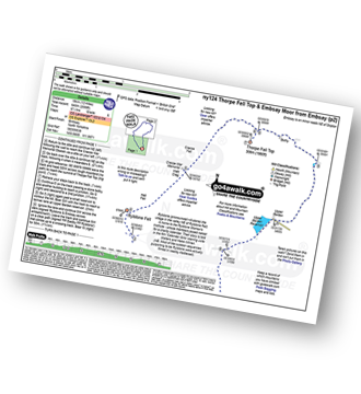
Route Summary:
Embsay - Embsay Reservoir - Embsay Moor - Crookrise Crag Top - Waterfall Gill Beck - Rylstone Fell - Rylstone Cross - Watt Crag - Cracoe Fell - Cracoe War Memorial Cross Obelisk - Thorpe Fell Top - Upper Barden Reservoir - Embsay
|
Vital Statistics:
| Length: | 13.75 miles (22 km) |
| Ascent: | 2,660ft (811m) |
| Time: | 7½ hrs |
| Grade: |  |
Route Summary:
Embsay - Embsay Reservoir - Embsay Moor - Crookrise Crag Top - Waterfall Gill Beck - Rylstone Fell - Rylstone Cross - Rylstone - Hetton - Flasby - Rough Haw - Sharp Haw - Embsay


