![]()
Meugher
575m (1887ft)
The Southern Dales Area, The Yorkshire Dales, North Yorkshire, England /England
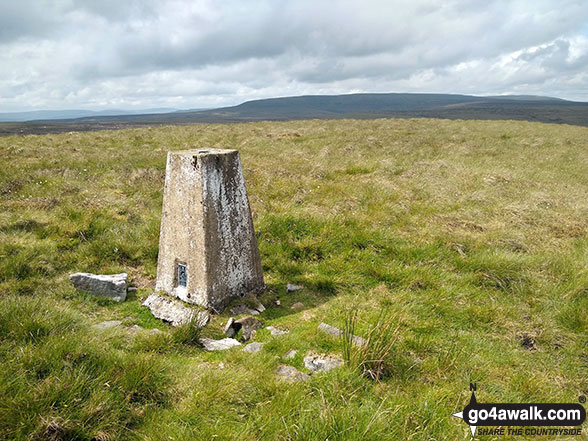
The summit of Meugher is marked by an Ordnance Survey Trig Point.
Not familiar with this top?
   |
|---|
Vital Statistics:
| Length: | 11mls (17.5km) |
|---|---|
| Ascent: | 1,181ft (360m) |
| Time: | 5.25hrs |
| Grade: |  (Moderate) (Moderate) |
Route Summary:
Yarnbury - Grassington Lead Mines - Duke's New Road (Track) - Hebden Beck - Cupola Corner - Deep Cut - Grassington Moor - Rather Standard Side - Sleet Moor - Rather Standard End - Henstone Band - Meugher Dike - Meugher Drive - Meugher - Friar Hood - Sandy Gate - Sandy Gate Pike Shelter - Mossdale - Mossdale Shooting Lodge - Mossdale Beck - Mossdale Scar - Bycliffe Road (Track) - Bycliffe - Kelber - Seeds Hill - Green Hill Pasture - Back Pasture - Downs Pasture - High Barn (ruin) - New Pasture Edge - Yarnbury
See Meugher and the surrounding tops on our free-to-access 'Google Style' Peak Bagging Maps:
The Southern Dales Area of The Yorkshire Dales National Park
Less data - quicker to download
The Whole of The Yorkshire Dales National Park
More data - might take a little longer to download
See Meugher and the surrounding tops on our downloadable Peak Bagging Map in PDF format:

NB: Whether you print off a copy or download it to your phone, this PDF Peak Baggers' Map might prove incredibly useful when your are up there on the tops and you cannot get a phone signal.
You can find Meugher & all the walks that climb it on these unique free-to-access Interactive Walk Planning Maps:
1:25,000 scale OS Explorer Map (orange/yellow covers):
1:50,000 scale OS Landranger Map (pink/magenta covers):
 Fellow go4awalkers who have already walked, climbed, summited & bagged Meugher
Mark Davidson walked up it on June 24th, 2020 [from/via/route] Walk ny161 Meugher from Yarnbury, Grassington [with] Alone [weather] Dry with sunny periods. More importantly, dry underfoot!!
Tony Rogerson climbed it on January 23rd, 2016 [from/via/route] Yarnbury Henstone Band Meugher Sandy Gate Mossdale Kelber [with] Floss [weather] Wind & mist on top, clear & calm lower down - Not TOO wet at all, considering the recent weather. Possibly the best way to approach this hill.
Trevor Lipscombe has bagged it [from/via/route] Yarnbury, NNE of Grassington, by car only, plenty of parking.. Can also be accessed from Conistone, NNW of Grassington off B6160, shorter distance, but greater gain of height, on a bus route (bus stops at Kilnsey). Use map OL2. - Follow good tracks & paths to Sandy Gate, MR030712. Then follow National Park boundary fence S & E to approx MR040694, roughish grass, can be boggy. To NE you should see grouse butts, head to these & join a track which services the butts & follow this N to the foot of Meugher. Climb what is claimed to be the least visited peak in Yorkshire. Return by same route.
To add (or remove) your name and experiences on this page - Log On and edit your Personal Mountain Bagging Record
More Photographs & Pictures of views from, on or of Meugher
Send us your photographs and pictures on, of, or from Meugher
If you would like to add your walk photographs and pictures to this page, please send them as email attachments (configured for any computer) along with your name to:
and we shall do our best to publish them.
(Guide Resolution = 300dpi. At least = 660pixels (wide) x 440 pixels (high).)

You can also submit photos via our Facebook Page.
NB. Please indicate where each photo was taken and whether you wish us to credit your photos with a Username or your First Name/Last Name.
Not familiar with this top?