8 easy-to-follow walk, route maps of all grades on OS Explorer Map 111 Bude, Boscastle & Tintagel
Eight easy-to-follow walk, route maps of all grades on OS Explorer Map 111 Bude, Boscastle & Tintagel in Walk Grade OrderTap/mouse over a coloured circle (1-3 easy walks, 4-6 moderate walks, 7-9 hard walks) and click to select.
You can use these checkboxes to show only the grades of walk you are interested in:-
Eight easy-to-follow walk, route maps of all grades on OS Explorer Map 111 Bude, Boscastle & Tintagel in Walk Grade Order
Scroll down the list of walks below & click on each walk title (in blue) to locate it on the map above.
See this list of walks, routes & maps in:
Grade Order | Length Order | Time Order | Walk Number or Start Location Order
NB. To reverse (toggle) this order, click Grade Order again
   |
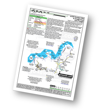
Vital Statistics:
| Length: | 4.75 miles (7.5 km) |
| Ascent: | 807ft (246m) |
| Time: | 2½ hrs |
| Grade: |  |
Route Summary:
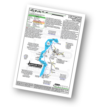
Tintagel - Tintagel Castle - Tintagel Haven - Tintagel Head - Glebe Cliff - Dunderhole Point - Penhallic Point - Hole Beach - Trebarwith Sands - Trelake - Treknow - Two Acre Farm - Tintagel
|
Vital Statistics:
| Length: | 7 miles (11 km) |
| Ascent: | 1,789ft (545m) |
| Time: | 4½ hrs |
| Grade: |  |
Route Summary:
Boscastle - The South West Coast Path - River Valency - Boscastle Harbour - Penally Point - Penally Hill - Pentargon Bay - Pentargon Falls - Beeny Cliff - Seals Hole - Fire Beacon Point - Beeny - Trebyla Farm - Penvention Farm - St Julietta's Church - River Valency - Boscastle
|
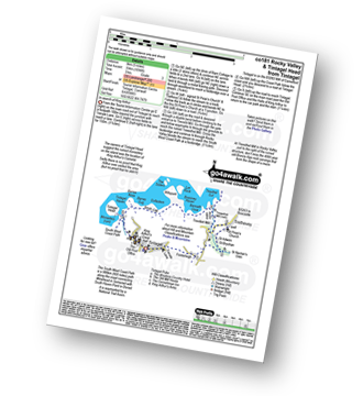
Vital Statistics:
| Length: | 11.25 miles (18 km) |
| Ascent: | 3,197ft (974m) |
| Time: | 7½ hrs |
| Grade: |  |
Route Summary:
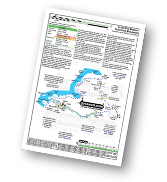
Boscastle - The South West Coast Path - River Valency - Boscastle Harbour - Penally Point - Penally Hill - Pentargon Bay - Pentargon Falls - Beeny Cliff - Seals Hole - Fire Beacon Point - Beeny - Trebyla Farm - Penvention Farm - St Julietta's Church - River Valency - Minster Wood - Upper Boscastle - Trehane Farm - Trevalga - The South West Coast Path - Grower Rock - Grower Gut - Western Blackapit - Willapark - Boscastle Harbour - Boscastle
|
Vital Statistics:
| Length: | 3.25 miles (5 km) |
| Ascent: | 765ft (233m) |
| Time: | 2 hrs |
| Grade: |  |
Route Summary:
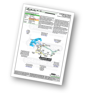
Boscastle - River Valency - Minster Wood - Jordan Valley - Upper Boscastle - Boscastle Harbour - Boscastle
|
Vital Statistics:
| Length: | 6.75 miles (11 km) |
| Ascent: | 1,234ft (376m) |
| Time: | 3.75hrs |
| Grade: |  |
Route Summary:
Tintagel - Fenterleigh - St Nectan's Glen - St Piran's Church - Trethevey - Trevalga - The South West Coast Path - Ladies Window - Trevalga Cliff - Trewthet Gut - Trewethett Mill - Rocky Valley - Benoath Cove - Bossiney Haven - Gullastern - Smith Cliff - Barras Gut - Barras Nose - Tintagel Haven - Tintagel Castle - Tintagel Head - Tintagel
|
Vital Statistics:
| Length: | 6.25 miles (10 km) |
| Ascent: | 1,729ft (527m) |
| Time: | 4 hrs |
| Grade: | |
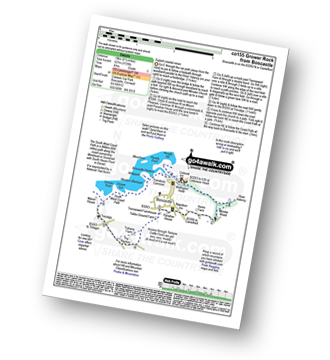
Route Summary:
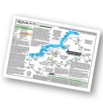
Boscastle - River Valency - Minster Wood - Upper Boscastle - Trehane Farm - Trevalga - The South West Coast Path - Grower Rock - Grower Gut - Western Blackapit - Willapark - Boscastle Harbour - Boscastle
|
Vital Statistics:
| Length: | 10.75 miles (17 km) |
| Ascent: | 1,983ft (568m) |
| Time: | 5.75hrs |
| Grade: |  |
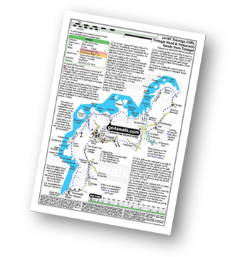
Route Summary:
Tintagel - Fenterleigh - St Nectan's Glen - St Piran's Church - Trethevey - Trevalga - The South West Coast Path - Ladies Window - Trevalga Cliff - Trewthet Gut - Trewethett Mill - Rocky Valley - Benoath Cove - Bossiney Haven - Gullastern - Smith Cliff - Barras Gut - Barras Nose - Tintagel Haven - Tintagel Head - Glebe Cliff - Dunderhole Point - Penhallic Point - Hole Beach - Trebarwith Sands - Trelake - Treknow - Two Acre Farm - Tintagel
|
Vital Statistics:
| Length: | 5 miles (8 km) |
| Ascent: | 1,096ft (334m) |
| Time: | 3 hrs |
| Grade: | |
Route Summary:
Tintagel - Fenterleigh - St Nectan's Glen - St Piran's Church - Trethevey - Trevelleit Mill - Trewethett Mill - Rocky Valley - The South West Coast Path - Benoath Cove - Bossiney Haven - Gullastern - Smith Cliff - Barras Gut - Barras Nose - Tintagel Haven - Tintagel Castle - Tintagel Head - Tintagel
See this list of walks, routes & maps in:
Grade Order | Length Order | Time Order | Walk Number or Start Location Order
NB. To reverse (toggle) this order, click Grade Order again


