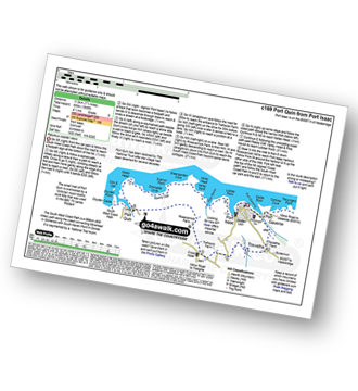
9 easy-to-follow walk, route maps of all grades on OS Explorer Map 106 Newquay & Padstow
Nine easy-to-follow walk, route maps of all grades on OS Explorer Map 106 Newquay & Padstow in Walk Grade OrderTap/mouse over a coloured circle (1-3 easy walks, 4-6 moderate walks, 7-9 hard walks) and click to select.
You can use these checkboxes to show only the grades of walk you are interested in:-
Nine easy-to-follow walk, route maps of all grades on OS Explorer Map 106 Newquay & Padstow in Walk Grade Order
Scroll down the list of walks below & click on each walk title (in blue) to locate it on the map above.
See this list of walks, routes & maps in:
Grade Order | Length Order | Time Order | Walk Number or Start Location Order
NB. To reverse (toggle) this order, click Grade Order again
   |
Vital Statistics:
| Length: | 5.5 miles (9 km) |
| Ascent: | 1,208ft (368m) |
| Time: | 3½ hrs |
| Grade: |  |
Route Summary:
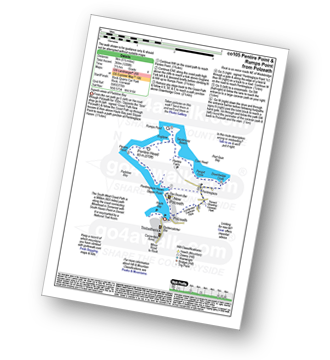
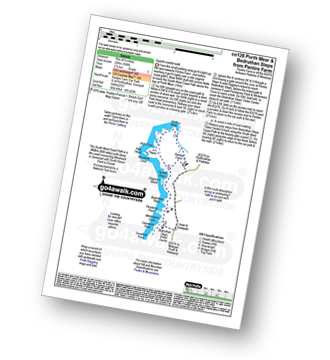
Trebetherick - The South West Coast Path - Polzeath - New Polzeath - Slipper Point - Pentireglaze Haven - Pentire Point - Pentire Head - Guglane - Rumps Point - Sandinway Beach - Com Head - Pengrit Cove - Downhedge Cove - Pentireglaze - Polzeath - Trebetherick
|
Vital Statistics:
| Length: | 4 miles (6.5 km) |
| Ascent: | 391ft (119m) |
| Time: | 2 hrs |
| Grade: |  |
Route Summary:
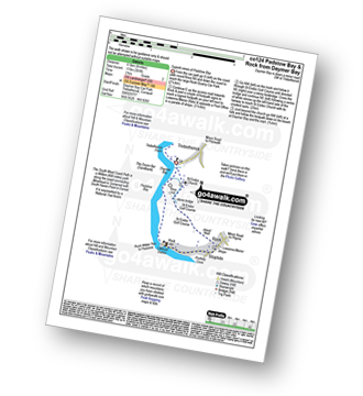
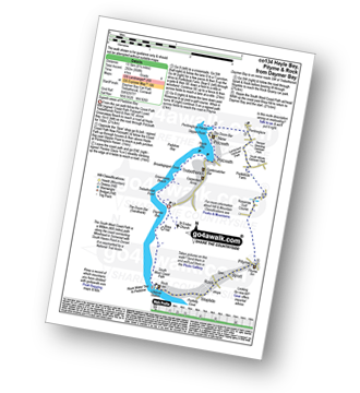
Daymer Bay (Trebetherick) - The South West Coast Path - Brea Hill - Rock (Padstow Bay) - St Endoc Golf Course - St Endoc Church - Daymer Bay (Trebetherick)
|
Vital Statistics:
| Length: | 11.75 miles (19 km) |
| Ascent: | 1,867ft (569m) |
| Time: | 6.25hrs |
| Grade: |  |
Route Summary:
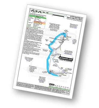
Rock (Padstow Bay) - The South West Coast Path - Brea Hill - Daymer Bay (Trebetherick) - Trebetherick Point - Greenaway Beach - Broadagogue Cove - Hayle Bay - Trebetherick - Polzeath - New Polzeath - Slipper Point - Pentireglaze Haven - Pentire Point - Pentire Head - Guglane - Rumps Point - Sandinway Beach - Com Head - Pengrit Cove - Downhedge Cove - Pentireglaze - Portkillock Farm - Roserrow - Pityme - Splatt - Stoptide - Rock (Padstow Bay)
|
Vital Statistics:
| Length: | 5 miles (8 km) |
| Ascent: | 952ft (290m) |
| Time: | 2.75hrs |
| Grade: |  |
Route Summary:
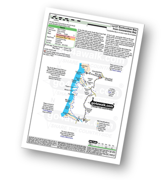
Constantine Bay - The South West Coast Path - Treyarnon Point - Treyarnon Bay - Trethias Island - Pepper Cove - Warren Cove - Fox Cove - Minnows Islands - Will's Rock - Porthcothan Bay - Carnevas - Trethias Farm - Treyarnon Farm - Constantine Bay
|
Vital Statistics:
| Length: | 4.5 miles (7 km) |
| Ascent: | 748ft (228m) |
| Time: | 2½ hrs |
| Grade: | |
Route Summary:
Pentire Farm - Porth Mear - The South West Coast Path - High Cove - Park Head - Mackerel Cove - Pentire Steps - Diggory's Island - Bedruthan Steps - Pendarve Point - Whitestone Cove - Bedruthan Steps Visitor Centre - B3276 - Pentire Farm
|
Vital Statistics:
| Length: | 8.25 miles (13.5 km) |
| Ascent: | 958ft (292m) |
| Time: | 4 hrs |
| Grade: | |
Route Summary:
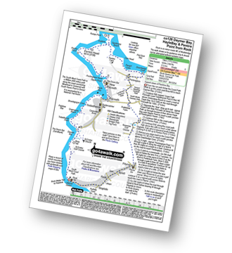
Daymer Bay (Trebetherick) - The South West Coast Path - Trebetherick Point - Greenaway Beach - Broadagogue Cove - Hayle Bay - Trebetherick - Polzeath - New Polzeath - Slipper Point - Pentireglaze Haven - Pentireglaze - Portkillock Farm - Roserrow - Pityme - Splatt - Stoptide - Rock (Padstow Bay) - St Endoc Church - Daymer Bay (Trebetherick)
|
Vital Statistics:
| Length: | 6.5 miles (10 km) |
| Ascent: | 755ft (230m) |
| Time: | 3 hrs |
| Grade: | |
Route Summary:
Rock (Padstow Bay) - Porthilly Cove - Stoptide - Rock (Padstow Bay) - St Endoc Golf Course - St Endoc Church - Trebetherick - The South West Coast Path - Broadagogue Cove - Greenaway Beach - Padstow Bay - Daymer Bay (Trebetherick) - Brea Hill - Rock (Padstow Bay)
|
Vital Statistics:
| Length: | 6.25 miles (10 km) |
| Ascent: | 945ft (288m) |
| Time: | 3.25hrs |
| Grade: | |
Route Summary:
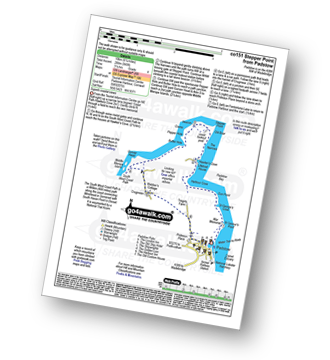
Padstow - Padstow Harbour - The South West Coast Path - St Saviour's Point - St George's Cove - Gun Point - Harbour Cove - Hawker's Cove - The Narrows - Old Boad - Stepper Point - Stepper Point Beacon - Crams - Pepper Hole - Butter Hole - Ginver Head - Middle Merope Islands - Crugmeer - Tregirls Farm - Prideaux Place - Padstow - Padstow Harbour.
|
Vital Statistics:
| Length: | 7.25 miles (11.5 km) |
| Ascent: | 1,805ft (550m) |
| Time: | 4½ hrs |
| Grade: |  |
Route Summary:
Port Isaac - Port Gaverne - Trewetha - Trelights - Rosecarrock Farm - Port Quin - Kellan Head - Downgate Cove - Greengarden Cove - Varley Head - Varley Sands - Pine Haven - Lobber Point - Port Isaac
See this list of walks, routes & maps in:
Grade Order | Length Order | Time Order | Walk Number or Start Location Order
NB. To reverse (toggle) this order, click Grade Order again


