Walks Routes Maps from Miller's Dale Station in The White Peak Area, The Peak District, Derbyshire in Walk Grade Order
Route maps for Walks that start, or go through, Miller's Dale Station in The White Peak Area, The Peak District, Derbyshire, England in Walk Grade Order
Details of refreshments, pubs & parking are included on each Miller's Dale Station walk description.
   |
Vital Statistics:
| Length: | 4 miles (6.5 km) |
| Ascent: | 942ft (287m) |
| Time: | 2½ hrs |
| Grade: |  |
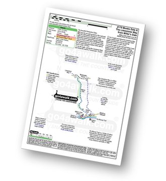
Route Summary:
Miller's Dale Station - Monks Dale - The Limestone Way - Monksdale House - The River Wye - Millers Dale - The Monsal Trail - Miller's Dale Station
|
Vital Statistics:
| Length: | 6 miles (9.5 km) |
| Ascent: | 515ft (157m) |
| Time: | 2.75hrs |
| Grade: | |
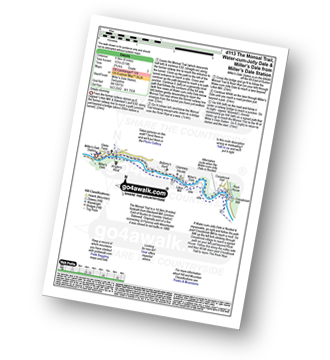
Route Summary:
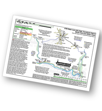
Miller's Dale Station - The Monsal Trail - The River Wye - Miller's Dale - Water-cum-Jolly Dale - Cressbrook Mill - The River Wye - Water-cum-Jolly Dale - Litton Mill - Bellamy's Bank - Miller's Dale Station
|
Vital Statistics:
| Length: | 6 miles (9.5 km) |
| Ascent: | 1,175ft (358m) |
| Time: | 3½ hrs |
| Grade: |  |
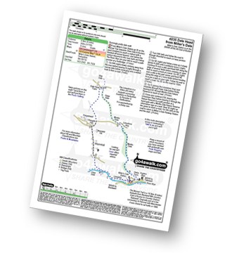
Route Summary:
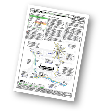
Miller's Dale Station - The Monsal Trail - River Wye - Wormhill - Dale Head - Peter Dale - Monk's Dale - Miller's Dale - Miller's Dale Station
|
Vital Statistics:
| Length: | 7.75 miles (12.5 km) |
| Ascent: | 840ft (256m) |
| Time: | 3.75hrs |
| Grade: | |
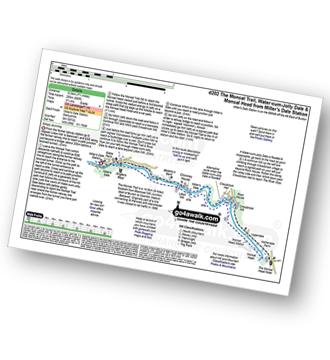
Route Summary:
Miller's Dale Station - The Monsal Trail - The River Wye - Miller's Dale - Water-cum-Jolly Dale - Monsal Head Viaduct - Monsal Head - Upperdale - Cressbrook Mill - The River Wye - Water-cum-Jolly Dale - Litton Mill - Bellamy's Bank - Miller's Dale Station
|
Vital Statistics:
| Length: | 9.75 miles (15.5 km) |
| Ascent: | 1,431ft (436m) |
| Time: | 5 hrs |
| Grade: |  |
Route Summary:
Miller's Dale Station - Monks Dale - The Limestone Way - Tideswell - Litton - Tansley Dale - Cressbrook Dale - Cressbrook - The Monsal Trail - Water-cum-Jolly Dale - Litton Mill - Miller's Dale - Miller's Dale Station
|
Vital Statistics:
| Length: | 8.5 miles (13.5 km) |
| Ascent: | 1,812ft (555m) |
| Time: | 5 hrs |
| Grade: | |
Route Summary:
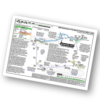
Wye Dale - Blackwell Junction - The Monsal Trail - Chee Dale - Miller's Dale Station - Miller's Dale - Priestcliffe - Taddington - Sough Top - Chelmorton - The Midshires Way - Burrs Farm - Marl Dale - Topley Pike Quarry - Wye Dale
|
Vital Statistics:
| Length: | 7.25 miles (11.5 km) |
| Ascent: | 1,411ft (430m) |
| Time: | 4 hrs |
| Grade: | |
Route Summary:
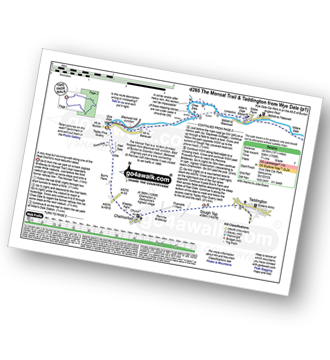
Tideswell - The Limestone Way - Monksdale House - Monks Dale - Miller's Dale Station - The Monsal Trail - Miller's Dale - The River Wye - Litton Mill - Tideswell Dale - Tideswell
|
Vital Statistics:
| Length: | 15.25 miles (24.5 km) |
| Ascent: | 1,759ft (536m) |
| Time: | 7.25hrs |
| Grade: |  |
Route Summary:
Wye Dale - The River Wye - Blackwell Junction - The Monsal Trail - Chee Dale - Miller's Dale Station - Miller's Dale - Litton Mill - Water-cum-Jolly Dale - Cressbrook - Monsal Dale - White Lodge - Deep Dale - Taddington - Sough Top - Chelmorton - Burrs Farm - Marl Dale - Wye Dale
See more easy-to-follow circular walks in The Peak District
See more easy-to-follow circular walks in Derbyshire


