
![]()
Gategill Fell Top
852m (2796ft)
The Northern Fells, The Lake District, Cumbria, England
Tap/mouse over a coloured circle (1-3 easy walks, 4-6 moderate walks, 7-9 hard walks) and click to select.
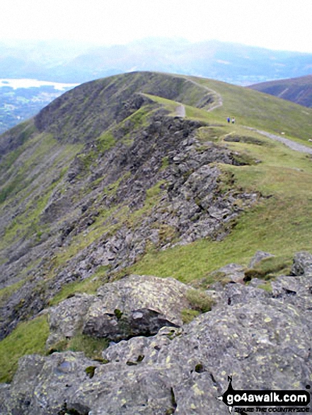
Gategill Fell Top with Knowe Crags beyond from Hallsfell Top, Blencathra or Saddleback
Not familiar with this top?
   |
|---|
Vital Statistics:
| Length: | 3.75ml (6km) |
|---|---|
| Ascent: | 2,398ft (731m) |
| Time: | 3.75hrs |
| Grade: |  (Moderate) (Moderate) |
Route Summary:
Threlkeld - Gategill Farm - Hall's Fell - Hall's Fell Ridge - Blencathra or Saddleback (Hallsfell Top) - Gategill Fell Top - Knowe Crags (Blease Fell) - Threlkeld
|
|---|
Vital Statistics:
| Length: | 6.25ml (10km) |
|---|---|
| Ascent: | 2,565ft (782m) |
| Time: | 4.75hrs |
| Grade: |  (Moderate) (Moderate) |
Route Summary:
Scales - Mousthwaite Comb - Scales Fell - Brunt Knott - Scales Beck - Scales Tarn - Sharp Edge - Atkinson Pike - Blencathra or Saddleback (Hallsfell Top) - Gategill Fell Top - Knowe Crag (Blease Fell) - Scales
See Gategill Fell Top and the surrounding tops on our free-to-access 'Google Style' Peak Bagging Maps:
The Northern Fells of The Lake District National Park
Less data - quicker to download
The Whole of The Lake District National Park
More data - might take a little longer to download
See Gategill Fell Top and the surrounding tops on our downloadable Peak Bagging Maps in PDF format:

NB: Whether you print off a copy or download it to your phone, these PDF Peak Baggers' Maps might prove incredibly useful when your are up there on the tops and you cannot get a phone signal.
*This version is marked with the walk routes you need to follow to Walk all 214 Wainwrights in just 59 walks.
You can find Gategill Fell Top & all the walks that climb it on these unique free-to-access Interactive Walk Planning Maps:
1:25,000 scale OS Explorer Map (orange/yellow covers):
1:50,000 scale OS Landranger Map (pink/magenta covers):
 Fellow go4awalkers who have already walked, climbed, summited & bagged Gategill Fell Top
Richard Holmes walked up Gategill Fell Top on March 13th, 2025 [from/via/route] Threlkeld [with] Myself. [weather] Very windy hail on top
Kevin Foster climbed Gategill Fell Top on April 13th, 2021 [from/via/route] Hallsfell Top [with] By myself [weather] Sunny to start but clouding over later. Clear visibility on tops. Cold when you stopped moving. - An easy saunter from Hallsfell Top there & back again. Superb views throughout. Found a nice sheltered rock to stop & have lunch about half way between the two tops on the way back. Hallsfell top was getting a bit congested by this point.
Richard Grimshaw bagged Gategill Fell Top on August 8th, 2020 [from/via/route] From: NY 3029 2563 via Knowe Crags [with] Carol Brown [weather] Sunny
James Brocken hiked Gategill Fell Top on September 14th, 2019 [weather] Windy on the top
Bill Salisbury summited Gategill Fell Top on August 27th, 2019 [from/via/route] Scales [with] Sue
Mark Davidson conquered Gategill Fell Top on September 22nd, 2006 [with] Alone [weather] Lovely & sunny & dry
Stephen Eddy scaled Gategill Fell Top on June 12th, 2015 [from/via/route] Scales via sharp edge [with] Mike Woodhouse, Tony Harris, Neil Whitehead [weather] Sunny
Lynn Symonds walked up Gategill Fell Top on June 15th, 2015 [from/via/route] Mungrisdale [with] Nicole [weather] Some cloud but dry
Iain Taylor climbed Gategill Fell Top on August 20th, 2011 [from/via/route] Threlkeld (NY 31857 25598)
Jane Chiarello bagged Gategill Fell Top on May 15th, 2011 [from/via/route] Threlkeld [weather] VVVVV wet
To add (or remove) your name and experiences on this page - Log On and edit your Personal Mountain Bagging Record
. . . [see more walk reports]
More Photographs & Pictures of views from, on or of Gategill Fell Top
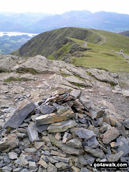
Hallsfell Top summit cairn with Gategill Fell Top and Knowe Crags in the background Blencathra or Saddleback
Send us your photographs and pictures on, of, or from Gategill Fell Top
If you would like to add your walk photographs and pictures featuring views from, on or of Gategill Fell Top to this page, please send them as email attachments (configured for any computer) along with your name to:
and we shall do our best to publish them.
(Guide Resolution = 300dpi. At least = 660pixels (wide) x 440 pixels (high).)

You can also submit photos via our Facebook Page.
NB. Please indicate where each photo was taken and whether you wish us to credit your photos with a Username or your First Name/Last Name.
Not familiar with this top?


