
![]()
Crutchenber Fell (Bowland Knotts)
430m (1411ft)
The South Pennines and The Forest of Bowland, Lancashire/North Yorkshire, England
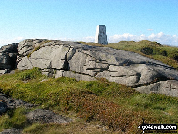
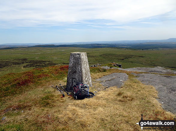
The summit of Crutchenber Fell (Bowland Knotts) is marked by an Ordnance Survey Trig Point.
Not familiar with this top?
   |
|---|
Vital Statistics:
| Length: | 7ml (11km) |
|---|---|
| Ascent: | 1,224ft (373m) |
| Time: | 3.75hrs |
| Grade: |  (Moderate) (Moderate) |
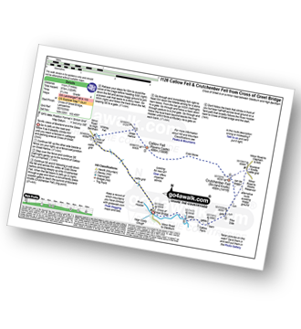
Route Summary:
Cross of Greet Bridge - The River Hodder - Cross of Greet - Great Harlow - Raven's Castle - Crowd Stones - Catlow Fell (Ravens Castle) - Hailshowers Fell - Cold Stone - Copy Nook - Knottend Well - Crutchenber Fell (Bowland Knotts) - Pike Side - Catlow Farm - Kearsdon Holes - The River Hodder - Cross of Greet Bridge
|
|---|
Vital Statistics:
| Length: | 8.75ml (14km) |
|---|---|
| Ascent: | 1,615ft (492m) |
| Time: | 5 hrs |
| Grade: |  (Moderate) (Moderate) |
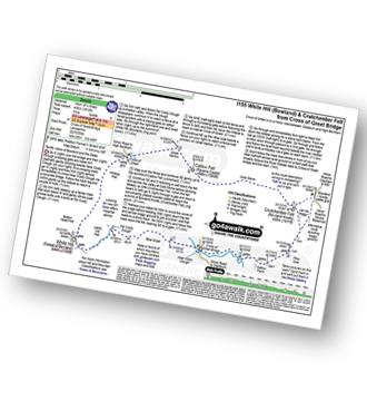
Route Summary:
Cross of Greet Bridge - Near Crosty Clough - Shooters' Huts - Far Costy Clough - White Hill (Forest of Bowland) - Botton Head Hill - Whitray Fell - Cross of Greet - Great Harlow - Raven's Castle - Crowd Stones - Catlow Fell (Ravens Castle) - Hailshowers Fell - Cold Stone - Copy Nook - Knottend Well - Crutchenber Fell (Bowland Knotts) - Pike Side - Catlow Farm - Kearsdon Holes - The River Hodder - Cross of Greet Bridge
|
|---|
Vital Statistics:
| Length: | 10.5mls (16.5km) |
|---|---|
| Ascent: | 1,697ft (499m) |
| Time: | 5½ hrs |
| Grade: | (Moderate) |
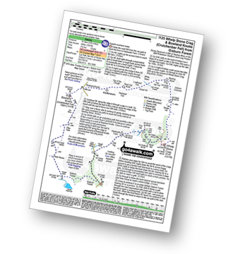
Route Summary:
Gisburn Forest - Halsteads Farm - Fair Hill - Herd Hill - Whelp Stone Crag - Brown Hill - Gisburn Common - Resting Stone - Ash Clough Swamp - Lawkland Fell - Rock Cat Knoll - Halstead Fell - Knotteranum - Crutchenber Fell (Bowland Knotts) - Pike Side - New House - Hasgill Beck - Stocks Reservoir - Gisburn Forest
See Crutchenber Fell (Bowland Knotts) and the surrounding tops on our free-to-access 'Google Style' Peak Bagging Map:
The Forest of Bowland and The South Pennines
Less data - quicker to download
See Crutchenber Fell (Bowland Knotts) and the surrounding tops on our downloadable Peak Bagging Map in PDF format:

NB: Whether you print off a copy or download it to your phone, this PDF Peak Baggers' Map might prove incredibly useful when your are up there on the tops and you cannot get a phone signal.
You can find Crutchenber Fell (Bowland Knotts) & all the walks that climb it on these unique free-to-access Interactive Walk Planning Maps:
1:25,000 scale OS Explorer Map (orange/yellow covers):
1:50,000 scale OS Landranger Map (pink/magenta covers):
 Fellow go4awalkers who have already walked, climbed, summited & bagged Crutchenber Fell (Bowland Knotts)
Adrian Howard walked up Crutchenber Fell (Bowland Knotts) on February 8th, 2012 [from/via/route] From minor road East of summit.
Margaret Richards climbed Crutchenber Fell (Bowland Knotts) on April 28th, 2014 [from/via/route] Bowland Knotts (Crutchenber Fell) from Gisburn Forest 10-12miles (l125) [with] Don and Mike - dry day
Christine Shepherd bagged Crutchenber Fell (Bowland Knotts) on July 1st, 2018 [from/via/route] Walked from Cross of Greet Bridge using walk l155 [with] On my own [weather] Glorious sunshine with a welcome breeze. - Enjoyed the climb up this fell. After White Hill it is good to be on clear paths with a wall to guide you to the summit. Great views of the Yorkshire Three Peaks & Pendle Hill from the summit.
To add (or remove) your name and experiences on this page - Log On and edit your Personal Mountain Bagging Record
More Photographs & Pictures of views from, on or of Crutchenber Fell (Bowland Knotts)
Send us your photographs and pictures on, of, or from Crutchenber Fell (Bowland Knotts)
If you would like to add your walk photographs and pictures featuring views from, on or of Crutchenber Fell (Bowland Knotts) to this page, please send them as email attachments (configured for any computer) along with your name to:
and we shall do our best to publish them.
(Guide Resolution = 300dpi. At least = 660pixels (wide) x 440 pixels (high).)

You can also submit photos via our Facebook Page.
NB. Please indicate where each photo was taken and whether you wish us to credit your photos with a Username or your First Name/Last Name.
Not familiar with this top?


