
![]()
Tarren y Gesail
667m (2189ft)
The Cadair Idris Area, Snowdonia, Gwynedd, Wales
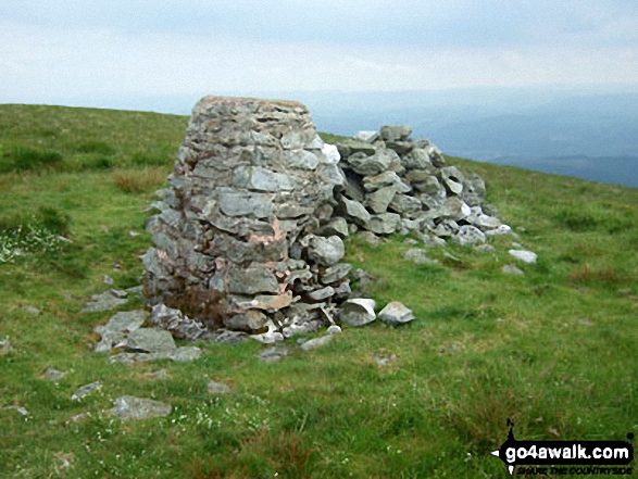
The summit of Tarren y Gesail is marked by an Ordnance Survey Trig Point.
Not familiar with this top?
   |
|---|
Vital Statistics:
| Length: | 10.5ml (17km) |
|---|---|
| Ascent: | 3,328ft (1,014m) |
| Time: | 7.25hrs |
| Grade: |  (Hard) (Hard) |
Route Summary:
Abergynolwyn - Nant Gwernol - Nant Gwernol Station - Drum House - Nant Moelfre - Moelfre - Tarrenhendre - Pant Gwyn (Tarrenhendre) - Mynydd Rhyd-galed - Foel y Geifr - Tarren y Gesail - Bryn-Eglwys Quarry - Abergynolwyn
See Tarren y Gesail and the surrounding tops on our free-to-access 'Google Style' Peak Bagging Maps:
The Cadair Idris area of Snowdonia National Park
Less data - quicker to download
The Whole of Snowdonia National Park
More data - might take a little longer to download
See Tarren y Gesail and the surrounding tops on our downloadable Peak Bagging Map in PDF format:

NB: Whether you print off a copy or download it to your phone, this PDF Peak Baggers' Map might prove incredibly useful when your are up there on the tops and you cannot get a phone signal.
You can find Tarren y Gesail & all the walks that climb it on these unique free-to-access Interactive Walk Planning Maps:
1:25,000 scale OS Explorer Map (orange/yellow covers):
1:50,000 scale OS Landranger Map (pink/magenta covers):
 Fellow go4awalkers who have already walked, climbed, summited & bagged Tarren y Gesail
Melfyn Parry walked up Tarren y Gesail on March 20th, 2025 [from/via/route] Started walk from car park opposite Railway Inn in the village of Abergynolwyn. Followed route GW148 apart from one minor alteration that saved quite a bit of distance. Between steps 3 & step 4, approximately 100m before reaching the log cabin you can take a steep scree path on your right which takes you up to a fence at the back of the cliffs which leads you directly up to the summit of Tarrenhendre, thus saving you the walk through the forest to reach step 5 & therefore avoids the need to retrace your steps to this point once you've bagged the summit. The remainder of the walk is as per the guidance. Once you leave the forest area at Foel y Geifr the ascent of Tarren y Gesail is very steep although on a descent grassy surface. [with] On my own [weather] It was a very warm day, 18C, glad I took lots of water. Breezy at times & mostly sunny. - Excellent views in all directions especially towards Cadair Idris.
Mark Davidson climbed Tarren y Gesail on June 30th, 2009 [from/via/route] Walk gw148 Tarrenhendre & Tarren y Gesail from Abergynolwyn [with] Alone [weather] Started of OK but a storm rolled in with thunder & lightning when if was on Tarrenhendre - all bit scary really
Donovan Suddell bagged Tarren y Gesail on October 9th, 2021 [from/via/route] Abergynolwyn [with] On my own [weather] Cloudy
Chris Hughes hiked Tarren y Gesail on September 19th, 2020 [from/via/route] Abergynolwyn [weather] Dry, very windy
Christina Lander summited Tarren y Gesail on May 12th, 2015 [from/via/route] Abergynolwyn - Nant Gwernol railway station - Tarrenhendre - Foel y Geifr - Tarren y Gesail - Bryn-Eglwys Quarry - Abergynolwyn [with] Dick & Suzanne [weather] Dry, sunny but quite windy
Paul Booth and Trevor Williams have both walked, climbed & bagged Tarren y Gesail.
To add (or remove) your name and experiences on this page - Log On and edit your Personal Mountain Bagging Record
More Photographs & Pictures of views from, on or of Tarren y Gesail
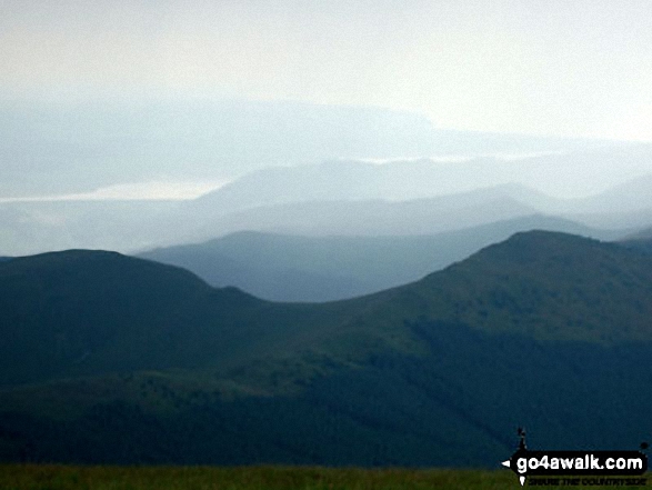
Mynydd Rhyd-galed (left) and Foel y Geifr with The Dovey Estuary beyond from Tarren y Gesail
Send us your photographs and pictures on, of, or from Tarren y Gesail
If you would like to add your walk photographs and pictures featuring views from, on or of Tarren y Gesail to this page, please send them as email attachments (configured for any computer) along with your name to:
and we shall do our best to publish them.
(Guide Resolution = 300dpi. At least = 660pixels (wide) x 440 pixels (high).)

You can also submit photos via our Facebook Page.
NB. Please indicate where each photo was taken and whether you wish us to credit your photos with a Username or your First Name/Last Name.
Not familiar with this top?


