
![]()
Crag Hill (Great Coum)
682m (2238ft)
The Southern Dales Area, The Yorkshire Dales, Cumbria, England
Tap/mouse over a coloured circle (1-3 easy walks, 4-6 moderate walks, 7-9 hard walks) and click to select.
The summit of Crag Hill (Great Coum) is marked by an Ordnance Survey Trig Point.

Not familiar with this top?
   |
|---|
Vital Statistics:
| Length: | 9ml (14.5km) |
|---|---|
| Ascent: | 19,112ft (583m) |
| Time: | 5.25hrs |
| Grade: |  (Moderate) (Moderate) |
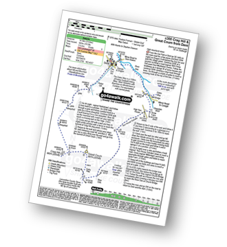
Route Summary:
Dent - Flinter Gill - Crag Hill (Great Coum) - Great Coum - Lancashire County Stone - Blea Gills - Nun House Outrake - The Dales Way - River Dee - Dent
See Crag Hill (Great Coum) and the surrounding tops on our free-to-access 'Google Style' Peak Bagging Maps:
The Southern Dales Area of The Yorkshire Dales National Park
Less data - quicker to download
The Whole of The Yorkshire Dales National Park
More data - might take a little longer to download
See Crag Hill (Great Coum) and the surrounding tops on our downloadable Peak Bagging Map in PDF format:

NB: Whether you print off a copy or download it to your phone, this PDF Peak Baggers' Map might prove incredibly useful when your are up there on the tops and you cannot get a phone signal.
You can find Crag Hill (Great Coum) & all the walks that climb it on this unique free-to-access Interactive Walk Planning Map:
 Fellow go4awalkers who have already walked, climbed, summited & bagged Crag Hill (Great Coum)
Adrian Howard walked up Crag Hill (Great Coum) on April 11th, 2024 [from/via/route] Followed path from gate at road junction with the signpost.
Ruth Nolan has climbed Crag Hill (Great Coum) [from/via/route] Dent, Flinter Gill, Crag Hill, Great Coum, Green Hill [with] Solo [weather] Scudding clouds, light breeze
Patrick Rogozinski has walked, climbed & bagged Crag Hill (Great Coum).
To add (or remove) your name and experiences on this page - Log On and edit your Personal Mountain Bagging Record
Send us your photographs and pictures on, of, or from Crag Hill (Great Coum)
If you would like to add your walk photographs and pictures featuring views from, on or of Crag Hill (Great Coum) to this page, please send them as email attachments (configured for any computer) along with your name to:
and we shall do our best to publish them.
(Guide Resolution = 300dpi. At least = 660pixels (wide) x 440 pixels (high).)

You can also submit photos via our Facebook Page.
NB. Please indicate where each photo was taken and whether you wish us to credit your photos with a Username or your First Name/Last Name.
Not familiar with this top?


