
![]()
Swyre Head
208m (682ft)
The Purbeck Heritage Coast, Dorset, England
Tap/mouse over a coloured circle (1-3 easy walks, 4-6 moderate walks, 7-9 hard walks) and click to select.
The summit of Swyre Head is marked by an Ordnance Survey Trig Point.
Swyre Head was demoted from Marilyn status in 2015
Not familiar with this top?
   |
|---|
Vital Statistics:
| Length: | 5.25ml (8.5km) |
|---|---|
| Ascent: | 1,234ft (376m) |
| Time: | 3.25hrs |
| Grade: |  (Moderate) (Moderate) |
Route Summary:
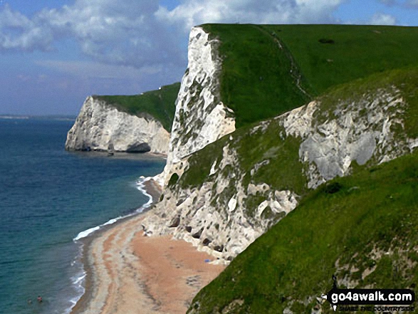
Durdle Door Car Park - Daggers Gate - The Warren - Chaldon Down - The South West Coast Path - West Bottom - Middle Bottom - Bat's Hole - Bat's Head - The Jurassic Coast - Swyre Head - Scratchy Bottom - Durdle Door - Durdle Door Car Park
|
|---|
Vital Statistics:
| Length: | 9ml (14.5km) |
|---|---|
| Ascent: | 1,191ft (363m) |
| Time: | 4½ hrs |
| Grade: |  (Moderate) (Moderate) |
Route Summary:
Lulworth Cove - West Lulworth - Durdle Door Caravan Park - Newlands Farm - Daggers Gate - The Warren - Chaldon Down - Ringstead Bay - The Jurassic Coast - The South West Coast Path - White Nothe - Whitenothe Cottage - West Bottom - Middle Bottom - Bats Hole - Bats Head - Swyre Head - Scratchy Bottom - Durdle Door - St Oswald's Bay - Hambury Tout - Dungy Head - Stair Hole - Lulworth Cove
A go4awalk.com downloadable Peak Bagging Map in PDF format featuring Swyre Head should be available soon.
Free-to-access Interactive Walk Planning Maps:
1:25,000 scale OS Explorer Map (orange/yellow covers):
1:50,000 scale OS Landranger Map (pink/magenta covers):
An Interactive Walk Planning Map for OS Landranger 195 Bournemouth & Purbeck, Wimborne Minster & Ringwood is not currently available
 Fellow go4awalkers who have already walked, climbed, summited & bagged Swyre Head
To add (or remove) your name and experiences on this page - Log On and edit your Personal Mountain Bagging Record
Send us your photographs and pictures on, of, or from Swyre Head
If you would like to add your walk photographs and pictures featuring views from, on or of Swyre Head to this page, please send them as email attachments (configured for any computer) along with your name to:
and we shall do our best to publish them.
(Guide Resolution = 300dpi. At least = 660pixels (wide) x 440 pixels (high).)

You can also submit photos via our Facebook Page.
NB. Please indicate where each photo was taken and whether you wish us to credit your photos with a Username or your First Name/Last Name.
Not familiar with this top?


