
![]()
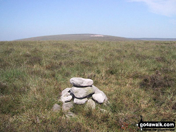
Black Mountain (South Top)
637m (2091ft)
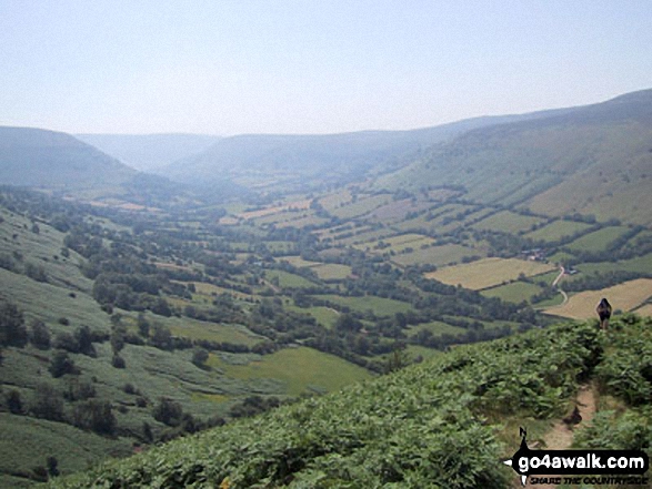
The Black Mountains, The Brecon Beacons, Powys/Herefordshire, Wales /England
Tap/mouse over a coloured circle (1-3 easy walks, 4-6 moderate walks, 7-9 hard walks) and click to select.
The summit of Black Mountain (South Top) is marked by an Ordnance Survey Trig Point.
Black Mountain (South Top) was demoted from 'Nuttall' status in January, 2018
Not familiar with this top?
   |
|---|
Vital Statistics:
| Length: | 10ml (16km) |
|---|---|
| Ascent: | 2,050ft (625m) |
| Time: | 5½ hrs |
| Grade: |  (Moderate) (Moderate) |
Route Summary:
Capel-y-ffin - The Offa's Dyke Path - Black Mountain (South Top) - Black Mountain - Hay Bluff - Gospel Pass - Twmpa (Lord Hereford's Knob) - Darren Lwyd - Capel-y-ffin
|
|---|
Vital Statistics:
| Length: | 14ml (22.5km) |
|---|---|
| Ascent: | 2,808ft (856m) |
| Time: | 8 hrs |
| Grade: |  (Hard) (Hard) |
Route Summary:
Capel-y-ffin - The Offa's Dyke Path - Black Mountain (South Top) - Black Mountain - Hay Bluff - Gospel Pass - Twmpa (Lord Hereford's Knob) - Rhiw y Fan - Rhos Dirion - Twyn Talycefn - Blacksmith's Anvil - Chwarel y Fan - Capel-y-ffin
See Black Mountain (South Top) and the surrounding tops on our free-to-access 'Google Style' Peak Bagging Maps:
The Black Mountains Area of Bannau Brycheiniog (The Brecon Beacons National Park)
Less data - quicker to download
The Whole of Bannau Brycheiniog (The Brecon Beacons National Park)
More data - might take a little longer to download
See Black Mountain (South Top) and the surrounding tops on our downloadable Peak Bagging Map in PDF format:

NB: Whether you print off a copy or download it to your phone, this PDF Peak Baggers' Map might prove incredibly useful when your are up there on the tops and you cannot get a phone signal.
You can find Black Mountain (South Top) & all the walks that climb it on these unique free-to-access Interactive Walk Planning Maps:
1:25,000 scale OS Explorer Map (orange/yellow covers):
1:50,000 scale OS Landranger Map (pink/magenta covers):
 Fellow go4awalkers who have already walked, climbed, summited & bagged Black Mountain (South Top)
Craig Barrell walked up Black Mountain (South Top) on October 26th, 2025 [with] solo
Jonathan Morris climbed Black Mountain (South Top) on April 18th, 2024 [from/via/route] Hay Bluff Car Park
Mark Davidson bagged Black Mountain (South Top) on July 14th, 2003 [from/via/route] Walk po116 Black Mountain & Rhos Dirion from Capel-y-ffin [with] Theresa [weather] Warm & sunny - really good walking weather
Tom Bond hiked Black Mountain (South Top) on May 1st, 2021 [from/via/route] Circular route from Blaen-y-Cwm car park. [with] Scott Gibbons - First wild camp & maiden voyage of MSR Elixir 2.
Rich Roberts summited Black Mountain (South Top) on April 3rd, 2017 [from/via/route] Offas Dyke [with] Sarah Wye
Chris Hughes conquered Black Mountain (South Top) on August 9th, 2020 [from/via/route] Hay Bluff car park [weather] Misty - Only a few meters visibility
Robert Shaw scaled Black Mountain (South Top) on May 13th, 2017 [from/via/route] From Llanthony whilst doing the Black Mountain Challenge. [with] Alcester Gents Sports Club [weather] Wet & misty
Christina Lander walked up Black Mountain (South Top) on March 18th, 2015 [from/via/route] Capel-y-ffin - Black Mountain (South Top) - Black Mountain - Hay Bluff - Gospel Pass - Twmpa - Rhos Dirion - Twyn Talycefn - Chwarel y Fan - Capel-y-ffin [with] Dick [weather] Dry with sunny spells
Vince Wetton climbed Black Mountain (South Top) on October 10th, 2014 [from/via/route] Po116 [with] RTM [weather] Sunny with showers - Long but satisfying walk
Robert Taylor-Marriott bagged Black Mountain (South Top) on October 10th, 2014 [from/via/route] Route 63: South Top, Black Mountain, Twmpa, Rhos Dirion, Chwarel y Fan (CB). [with] Vince Wetton and Robert Taylor-Marriott. [weather] Sunny, cloudy & light rain.
To add (or remove) your name and experiences on this page - Log On and edit your Personal Mountain Bagging Record
. . . [see more walk reports]
More Photographs & Pictures of views from, on or of Black Mountain (South Top)
Send us your photographs and pictures on, of, or from Black Mountain (South Top)
If you would like to add your walk photographs and pictures featuring views from, on or of Black Mountain (South Top) to this page, please send them as email attachments (configured for any computer) along with your name to:
and we shall do our best to publish them.
(Guide Resolution = 300dpi. At least = 660pixels (wide) x 440 pixels (high).)

You can also submit photos via our Facebook Page.
NB. Please indicate where each photo was taken and whether you wish us to credit your photos with a Username or your First Name/Last Name.
Not familiar with this top?


