All The Mountains, Peaks, Tops and Hills in Scottish Region 16: Scottish Region 16: Assynt and The Far North as a detailed list

Scottish Region 16: Assynt and The Far North region is the area enclosed by an imaginary line connecting:


If you include all the Munros, the Corbetts, the Grahams, the Donalds, the Murdos, the Marilyns, the Bridgets (Hills) and all the Mountains, Tops, Peaks and Hills with a Trig Point on them there are 92 tops to climb, bag & conquer and the highest point is Ben More Assynt at 998m (3,275ft).

munro
4/0
Munros

corbett
17/0
Corbetts

graham
16/0
Grahams

donald
0/0
Donalds

murdo
5/0
Murdos

marilyn
84/0
Scottish
Marilyns

Bridget
5/0
Scottish
Bridgets

Trig Point
37/0
Trig
Points


To see all Mountains, Peaks, Tops and Hills displayed in different ways - see the options in the left-hand column and towards the bottom of this page.


LOG ON and RELOAD this page to show which Mountains, Peaks, Tops and Hills you have already climbed, bagged & conquered [. . . more]


Page 3 of 4    Go to page: 1 2 3 4


See this list in: Alphabetical Order | Height Order
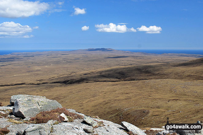
To reverse the order select the link again.


Mountain, Peak, Top or Hill:

Bagged


61. Creag Riabhach

485m (1,592ft)

  • Marilyn (848th in Scotland, 1018th in GB)
  • OS Trig Point

  • We hope to have walks that climb & bag Creag Riabhach very soon

    Google Maps Icon
    See the location of Creag Riabhach and walks up it on a google Map

    Creag Riabhach is on interactive maps:

  • OS Explorer (Orange Covers): 446
  • OS Landranger (Pink Covers): 9

  • A go4awalk.com Peak Bagging Map and Hill Tick List featuring Creag Riabhach will be available soon.


    62. Maiden Pap

    484m (1,588ft)

  • Marilyn (851st in Scotland, 1022nd in GB)

  • We hope to have walks that climb & bag Maiden Pap very soon

    Google Maps Icon
    See the location of Maiden Pap and walks up it on a google Map

    Maiden Pap is on interactive maps:

  • OS Explorer (Orange Covers): 444
  • OS Landranger (Pink Covers): 11 and 17

  • A go4awalk.com Peak Bagging Map and Hill Tick List featuring Maiden Pap will be available soon.


    63. Beinn Sgeireach

    476m (1,562ft)

  • Marilyn (859th in Scotland, 1037th in GB)
  • OS Trig Point

  • We hope to have walks that climb & bag Beinn Sgeireach very soon

    Google Maps Icon
    See the location of Beinn Sgeireach and walks up it on a google Map

    Beinn Sgeireach is on interactive maps:

  • OS Explorer (Orange Covers): 440
  • OS Landranger (Pink Covers): 16

  • A go4awalk.com Peak Bagging Map and Hill Tick List featuring Beinn Sgeireach will be available soon.


    64. Creag Dhubh Bheag

    472m (1,549ft)

  • Marilyn (862nd in Scotland, 1040th in GB)

  • We hope to have walks that climb & bag Creag Dhubh Bheag very soon

    Google Maps Icon
    See the location of Creag Dhubh Bheag and walks up it on a google Map

    Creag Dhubh Bheag is on interactive maps:

  • OS Explorer (Orange Covers): 440
  • OS Landranger (Pink Covers): 16

  • A go4awalk.com Peak Bagging Map and Hill Tick List featuring Creag Dhubh Bheag will be available soon.


    65. Meall an Fhuarain (Strath Vagastie)

    472m (1,549ft)

  • Marilyn (864th in Scotland, 1042nd in GB)

  • We hope to have walks that climb & bag Meall an Fhuarain (Strath Vagastie) very soon

    Google Maps Icon
    See the location of Meall an Fhuarain (Strath Vagastie) and walks up it on a google Map

    Meall an Fhuarain (Strath Vagastie) is on interactive maps:

  • OS Explorer (Orange Covers): 443
  • OS Landranger (Pink Covers): 16

  • A go4awalk.com Peak Bagging Map and Hill Tick List featuring Meall an Fhuarain (Strath Vagastie) will be available soon.


    66. An Grianan (Strath Shinary)

    467m (1,533ft)

  • Marilyn (875th in Scotland, 1056th in GB)

  • We hope to have walks that climb & bag An Grianan (Strath Shinary) very soon

    Google Maps Icon
    See the location of An Grianan (Strath Shinary) and walks up it on a google Map

    An Grianan (Strath Shinary) is on interactive maps:

  • OS Explorer (Orange Covers): 446
  • OS Landranger (Pink Covers): 9

  • A go4awalk.com Peak Bagging Map and Hill Tick List featuring An Grianan (Strath Shinary) will be available soon.


    67. Feinne-bheinn Mhor

    465m (1,526ft)

  • Marilyn (885th in Scotland, 1068th in GB)

  • We hope to have walks that climb & bag Feinne-bheinn Mhor very soon

    Google Maps Icon
    See the location of Feinne-bheinn Mhor and walks up it on a google Map

    Feinne-bheinn Mhor is on interactive maps:

  • OS Explorer (Orange Covers): 447
  • OS Landranger (Pink Covers): 9

  • A go4awalk.com Peak Bagging Map and Hill Tick List featuring Feinne-bheinn Mhor will be available soon.


    68. Fashven

    460m (1,510ft)

  • Marilyn (894th in Scotland, 1079th in GB)

  • We hope to have walks that climb & bag Fashven very soon

    Google Maps Icon
    See the location of Fashven and walks up it on a google Map

    Fashven is on interactive maps:

  • OS Explorer (Orange Covers): 446
  • OS Landranger (Pink Covers): 9

  • A go4awalk.com Peak Bagging Map and Hill Tick List featuring Fashven will be available soon.


    69. Beinn Lunndaidh

    447m (1,467ft)

  • Marilyn (920th in Scotland, 1112th in GB)
  • OS Trig Point

  • We hope to have walks that climb & bag Beinn Lunndaidh very soon

    Google Maps Icon
    See the location of Beinn Lunndaidh and walks up it on a google Map

    Beinn Lunndaidh is on interactive maps:

  • OS Explorer (Orange Covers): 441
  • OS Landranger (Pink Covers): 17

  • A go4awalk.com Peak Bagging Map and Hill Tick List featuring Beinn Lunndaidh will be available soon.


    70. Cnoc an Liath-bhaid Mhoir

    434m (1,424ft)

  • Marilyn (940th in Scotland, 1137th in GB)
  • OS Trig Point

  • We hope to have walks that climb & bag Cnoc an Liath-bhaid Mhoir very soon

    Google Maps Icon
    See the location of Cnoc an Liath-bhaid Mhoir and walks up it on a google Map

    Cnoc an Liath-bhaid Mhoir is on interactive maps:

  • OS Explorer (Orange Covers): 444
  • OS Landranger (Pink Covers): 16

  • A go4awalk.com Peak Bagging Map and Hill Tick List featuring Cnoc an Liath-bhaid Mhoir will be available soon.


    71. Beinn Dearg (Cape Wrath)

    424m (1,390ft)

  • Marilyn (956th in Scotland, 1156th in GB)
  • Beinn Dearg (Cape Wrath) was promoted to Marilyn status in 2018


    We hope to have walks that climb & bag Beinn Dearg (Cape Wrath) very soon

    Google Maps Icon
    See the location of Beinn Dearg (Cape Wrath) and walks up it on a google Map

    Beinn Dearg (Cape Wrath) is on interactive maps:

  • OS Explorer (Orange Covers): 446
  • OS Landranger (Pink Covers): 9

  • A go4awalk.com Peak Bagging Map and Hill Tick List featuring Beinn Dearg (Cape Wrath) will be available soon.


    72. Braigh na h-Eaglaise

    424m (1,390ft)

  • Marilyn (957th in Scotland, 1157th in GB)

  • We hope to have walks that climb & bag Braigh na h-Eaglaise very soon

    Google Maps Icon
    See the location of Braigh na h-Eaglaise and walks up it on a google Map

    Braigh na h-Eaglaise is on interactive maps:

  • OS Explorer (Orange Covers): 444
  • OS Landranger (Pink Covers): 17

  • A go4awalk.com Peak Bagging Map and Hill Tick List featuring Braigh na h-Eaglaise will be available soon.


    73. Meall Meadhonach (Loch Eriboll)

    423m (1,388ft)

  • Marilyn (959th in Scotland, 1161st in GB)

  • We hope to have walks that climb & bag Meall Meadhonach (Loch Eriboll) very soon

    Google Maps Icon
    See the location of Meall Meadhonach (Loch Eriboll) and walks up it on a google Map

    Meall Meadhonach (Loch Eriboll) is on interactive maps:

  • OS Explorer (Orange Covers): 446
  • OS Landranger (Pink Covers): 9

  • A go4awalk.com Peak Bagging Map and Hill Tick List featuring Meall Meadhonach (Loch Eriboll) will be available soon.


    74. Beinn Dubhain

    417m (1,369ft)

  • Marilyn (967th in Scotland, 1171st in GB)

  • We hope to have walks that climb & bag Beinn Dubhain very soon

    Google Maps Icon
    See the location of Beinn Dubhain and walks up it on a google Map

    Beinn Dubhain is on interactive maps:

  • OS Explorer (Orange Covers): 444
  • OS Landranger (Pink Covers): 17

  • A go4awalk.com Peak Bagging Map and Hill Tick List featuring Beinn Dubhain will be available soon.


    75. Meadie Ridge

    414m (1,358ft)

  • Marilyn (975th in Scotland, 1181st in GB)

  • We hope to have walks that climb & bag Meadie Ridge very soon

    Google Maps Icon
    See the location of Meadie Ridge and walks up it on a google Map

    Meadie Ridge is on interactive maps:

  • OS Explorer (Orange Covers): 447
  • OS Landranger (Pink Covers): 9

  • A go4awalk.com Peak Bagging Map and Hill Tick List featuring Meadie Ridge will be available soon.


    76. Ben Hutig

    408m (1,339ft)

  • Marilyn (982nd in Scotland, 1189th in GB)
  • OS Trig Point

  • We hope to have walks that climb & bag Ben Hutig very soon

    Google Maps Icon
    See the location of Ben Hutig and walks up it on a google Map

    Ben Hutig is on interactive maps:

  • OS Explorer (Orange Covers): 447
  • OS Landranger (Pink Covers): 10

  • A go4awalk.com Peak Bagging Map and Hill Tick List featuring Ben Hutig will be available soon.


    77. Creag Thoraraidh

    405m (1,329ft)

  • Marilyn (987th in Scotland, 1195th in GB)
  • OS Trig Point

  • We hope to have walks that climb & bag Creag Thoraraidh very soon

    Google Maps Icon
    See the location of Creag Thoraraidh and walks up it on a google Map

    Creag Thoraraidh is on interactive maps:

  • OS Explorer (Orange Covers): 444
  • OS Landranger (Pink Covers): 17

  • A go4awalk.com Peak Bagging Map and Hill Tick List featuring Creag Thoraraidh will be available soon.


    78. Beinn a' Mhadaidh

    403m (1,323ft)

  • OS Trig Point

  • We hope to have walks that climb & bag Beinn a' Mhadaidh very soon

    Google Maps Icon
    See the location of Beinn a' Mhadaidh and walks up it on a google Map

    Beinn a' Mhadaidh is on interactive maps:

  • OS Explorer (Orange Covers): 448
  • OS Landranger (Pink Covers): 10

  • A go4awalk.com Peak Bagging Map and Hill Tick List featuring Beinn a' Mhadaidh will be available soon.


    79. Cnoc na Maoile

    402m (1,319ft)

  • Marilyn (991st in Scotland, 1201st in GB)

  • We hope to have walks that climb & bag Cnoc na Maoile very soon

    Google Maps Icon
    See the location of Cnoc na Maoile and walks up it on a google Map

    Cnoc na Maoile is on interactive maps:

  • OS Explorer (Orange Covers): 444
  • OS Landranger (Pink Covers): 17

  • A go4awalk.com Peak Bagging Map and Hill Tick List featuring Cnoc na Maoile will be available soon.


    80. Creag nam Fiadh

    387m (1,270ft)

  • Marilyn (1013th in Scotland, 1230th in GB)
  • OS Trig Point

  • We hope to have walks that climb & bag Creag nam Fiadh very soon

    Google Maps Icon
    See the location of Creag nam Fiadh and walks up it on a google Map

    Creag nam Fiadh is on interactive maps:

  • OS Explorer (Orange Covers): 444
  • OS Landranger (Pink Covers): 17

  • A go4awalk.com Peak Bagging Map and Hill Tick List featuring Creag nam Fiadh will be available soon.


    81. Meall a' Chaise (Strath Brora)

    372m (1,220ft)

  • Marilyn (1039th in Scotland, 1265th in GB)
  • OS Trig Point

  • We hope to have walks that climb & bag Meall a' Chaise (Strath Brora) very soon

    Google Maps Icon
    See the location of Meall a' Chaise (Strath Brora) and walks up it on a google Map

    Meall a' Chaise (Strath Brora) is on interactive maps:

  • OS Explorer (Orange Covers): 443
  • OS Landranger (Pink Covers): 16

  • A go4awalk.com Peak Bagging Map and Hill Tick List featuring Meall a' Chaise (Strath Brora) will be available soon.


    82. Sgribhis-bheinn

    371m (1,218ft)

  • Marilyn (1040th in Scotland, 1266th in GB)
  • OS Trig Point

  • We hope to have walks that climb & bag Sgribhis-bheinn very soon

    Google Maps Icon
    See the location of Sgribhis-bheinn and walks up it on a google Map

    Sgribhis-bheinn is on interactive maps:

  • OS Explorer (Orange Covers): 446
  • OS Landranger (Pink Covers): 9

  • A go4awalk.com Peak Bagging Map and Hill Tick List featuring Sgribhis-bheinn will be available soon.


    83. An Socach (Strath Shinary)

    362m (1,188ft)

  • Marilyn (1048th in Scotland, 1278th in GB)

  • We hope to have walks that climb & bag An Socach (Strath Shinary) very soon

    Google Maps Icon
    See the location of An Socach (Strath Shinary) and walks up it on a google Map

    An Socach (Strath Shinary) is on interactive maps:

  • OS Explorer (Orange Covers): 446
  • OS Landranger (Pink Covers): 9

  • A go4awalk.com Peak Bagging Map and Hill Tick List featuring An Socach (Strath Shinary) will be available soon.


    84. Cnoc an Daimh Mor

    357m (1,171ft)

  • Marilyn (1054th in Scotland, 1289th in GB)

  • We hope to have walks that climb & bag Cnoc an Daimh Mor very soon

    Google Maps Icon
    See the location of Cnoc an Daimh Mor and walks up it on a google Map

    Cnoc an Daimh Mor is on interactive maps:

  • OS Explorer (Orange Covers): 447
  • OS Landranger (Pink Covers): 10

  • A go4awalk.com Peak Bagging Map and Hill Tick List featuring Cnoc an Daimh Mor will be available soon.


    85. Beinn Domhnaill

    349m (1,145ft)

  • Marilyn (1059th in Scotland, 1301st in GB)

  • We hope to have walks that climb & bag Beinn Domhnaill very soon

    Google Maps Icon
    See the location of Beinn Domhnaill and walks up it on a google Map

    Beinn Domhnaill is on interactive maps:

  • OS Explorer (Orange Covers): 441
  • OS Landranger (Pink Covers): 21

  • A go4awalk.com Peak Bagging Map and Hill Tick List featuring Beinn Domhnaill will be available soon.


    86. Creag a' Ghobhair

    346m (1,136ft)

  • Marilyn (1062nd in Scotland, 1304th in GB)

  • We hope to have walks that climb & bag Creag a' Ghobhair very soon

    Google Maps Icon
    See the location of Creag a' Ghobhair and walks up it on a google Map

    Creag a' Ghobhair is on interactive maps:

  • OS Explorer (Orange Covers): 441
  • OS Landranger (Pink Covers): 21

  • A go4awalk.com Peak Bagging Map and Hill Tick List featuring Creag a' Ghobhair will be available soon.


    87. Meall nan Clach Ruadha

    335m (1,099ft)

  • Marilyn (1071st in Scotland, 1321st in GB)

  • We hope to have walks that climb & bag Meall nan Clach Ruadha very soon

    Google Maps Icon
    See the location of Meall nan Clach Ruadha and walks up it on a google Map

    Meall nan Clach Ruadha is on interactive maps:

  • OS Explorer (Orange Covers): 447 and 448
  • OS Landranger (Pink Covers): 10

  • A go4awalk.com Peak Bagging Map and Hill Tick List featuring Meall nan Clach Ruadha will be available soon.


    88. Ghlas-bheinn

    332m (1,090ft)

  • Marilyn (1074th in Scotland, 1327th in GB)

  • We hope to have walks that climb & bag Ghlas-bheinn very soon

    Google Maps Icon
    See the location of Ghlas-bheinn and walks up it on a google Map

    Ghlas-bheinn is on interactive maps:

  • OS Explorer (Orange Covers): 446
  • OS Landranger (Pink Covers): 9

  • A go4awalk.com Peak Bagging Map and Hill Tick List featuring Ghlas-bheinn will be available soon.


    89. Meall Dola

    323m (1,060ft)

  • Marilyn (1079th in Scotland, 1341st in GB)

  • We hope to have walks that climb & bag Meall Dola very soon

    Google Maps Icon
    See the location of Meall Dola and walks up it on a google Map

    Meall Dola is on interactive maps:

  • OS Explorer (Orange Covers): 441
  • OS Landranger (Pink Covers): 16

  • A go4awalk.com Peak Bagging Map and Hill Tick List featuring Meall Dola will be available soon.


    90. Beinn Akie

    288m (945ft)

  • Marilyn (1112th in Scotland, 1397th in GB)

  • We hope to have walks that climb & bag Beinn Akie very soon

    Google Maps Icon
    See the location of Beinn Akie and walks up it on a google Map

    Beinn Akie is on interactive maps:

  • OS Explorer (Orange Covers): 446
  • OS Landranger (Pink Covers): 9

  • A go4awalk.com Peak Bagging Map and Hill Tick List featuring Beinn Akie will be available soon.


    Page 3 of 4    Go to page: 1 2 3 4


    View all 91 Mountains, Peaks, Tops and Hills in Scottish Region 16: Assynt and The Far North:


    Is there a Mountain, Peak, Top or Hill missing from the above google map or list?

    Let us know an we will add it to our database.


    Follow go4awalk.com on Twitter Follow go4awalk.com on Facebook


    Home


    Find new Friends to go walking with

    Walk all 214 Wainwrights in just 59 Walks. Download GPS Waypoints - Great Walks you must not miss!

    Walk The Yorkshire Three Peaks Challenge Walk - All the Latest Route Information, GPS Waypoints and Split Times to keep you on Schedule

    Walk The British Three Peaks Challenge Walk - All the Latest Route Information and GPS Waypoints

    See our pick of The Best Walks in The Lake District - Great Walks you must not miss!

    Walk our pick of the Best Lake District Ridge Walks - Great Walks you must not miss!

    Walk our pick of the Best Lake District Walks to do in the rain - Great Walks you must not miss!

    Walk our pick of The Best Walks in Snowdonia - Great Walks you must not miss!

    Walk our pick of The Best Ridge Walks in Wales - Walks you must not miss!

    Walk our pick of The Best Walks in The Brecon Beacons - Great Walks you must not miss!

    Walk our pick of The Best Walks in The Yorkshire Dales - Walks you must not miss!

    Walk our pick of The Best Walks in The Peak District - Walks you must not miss!

    Walk our pick of The Best Walks in The Forest of Bowland - Walks you must not miss!

    Walk our pick of The Best Walks in Shropshire - Walks you must not miss!

    Walk our pick of The Best Walks in Cheshire - Walks you must not miss!

    Walk our pick of The Best Walks in Lancashire - Walks you must not miss!

    Not sure where to walk next? Try Peak Bagging - Great Walks you must not miss!

    Not sure where to walk next? Walk part of a National Trail - Great Walks you must not miss!

    Walks with Downloadable and Uploadable GPS Waypoint Data

    Walking Kit and Gear Tested by Walkers

    Full Site Search