The Mountains, Peaks, Tops and Hills in Scottish Region 7: Scottish Region 7: The East Mounth - Glen Shee and Mount Keen to Montrose with all the tops you have already bagged first & then the ones you are yet to climb second.
Scottish Region 7: The East Mounth - Glen Shee and Mount Keen to Montrose region is the area enclosed by an imaginary line connecting:
- Braemar to Aberdeen via the A93 through Ballater, Aboyne, Banchory and Peterculter to the North
- Aberdeen to Stonehaven via the North Sea to the East
- Stonehaven to Blairgowrie and Rattray via the A926 through Laurencekirk, Brechin, Kirriemuir & Alyth to the South East
- Blairgowrie and Rattray to Braemar via the A9 through Bridge of Cally, Cray, Spittal of Glenshee, and Glen Shee to the West
If you count only the Munros there are 14 tops to climb, bag & conquer and the highest point is Lochnagar (Cac Carn Beag) at 1,155m (3,791ft).
To see these Mountains, Peaks, Tops and Hills displayed in different ways - see the options in the left-hand column and towards the bottom of this page.
![]() Your Personal Bagging Record for Scottish Region 7: The East Mounth - Glen Shee and Mount Keen to Montrose
Your Personal Bagging Record for Scottish Region 7: The East Mounth - Glen Shee and Mount Keen to Montrose
When logged on, you can mark each Mountain, Peak, Top or Hill as 'bagged' by either:
- if you opt to display the tops in this area using a google map, click or tap on its symbol on the map below. This will open a text window. Click or tap on the 'Record [mountain name] as Bagged, Climbed & Conquered' link towards the bottom of the text window, or
- if you opt to display the tops in this area as a list, click or tap on the red 'not yet' symbol to the right of the name of each 'top'
Either method will open a new page where you can complete all your details such as:
- when you bagged the Mountain, Peak, Top or Hill;
- which route you took
- who you went with
- what the weather was like
- any other comment that will remind you of the day
Once you have completed your details and click or tap the submit button, you will automatically return to this page and the top you bagged will show with a green tick.
NB. None of the above fields are 'mandatory' - you can leave them blank if you wish.
NNB. You also have the option whether to display your peak bagging exploits to other users of this site or keep them private so only you can see them when you are logged on.
Furthermore, since you can also access your Personal Mountain & Hill Bagging Record via go4awalk Mobile you can quickly & easily record, edit and view your achievements - whether you are at home/work on your desktop computer or in the pub/at the top of a mountain with your Mobile Phone. (You can even download your Personal Mountain & Hill Bagging Record as a .csv file for importing into and saving with spreadsheet software like Excel or NeoOffice!)
This facility costs one credit to initially access your personal bagging record. Once accessed, all other interactions, such as recording other Mountains, Peaks, Tops and Hills as 'bagged' or altering an existing bagging record, are free.
Click REGISTER to register and purchase credits.
LOG ON and RELOAD this page to show which Mountains, Peaks, Tops and Hills you have already climbed, bagged & conquered. [ . . . remove this text]
Scroll down this list of mountains, peaks, tops & hills below and tap/click on each name (in blue) to locate it on the map above.
See this list in: Alphabetical Order | Height Order‡
To reverse the order select the link again.
Mountain, Peak, Top or Hill already bagged:
Bagged
Top yet to be climbed, bagged & conquered:
Bagged

![]()
1. Lochnagar (Cac Carn Beag)
1155m (3791ft)
Munro
See more details, photos, trip reports and easy-to-follow walks up Lochnagar (Cac Carn Beag)
![]()
2. Carn a' Choire Boidheach
1110m (3643ft)
Munro
See more details, photos, trip reports and easy-to-follow walks up Carn a' Choire Boidheach
![]()
3. Glas Maol
1068m (3505ft)
Munro
See more details, photos, trip reports and easy-to-follow walks up Glas Maol
![]()
4. Cairn of Claise
1064m (3492ft)
Munro
See more details, photos, trip reports and easy-to-follow walks up Cairn of Claise
![]()
5. Carn an t-Sagairt Mor
1047m (3436ft)
Munro
See more details, photos, trip reports and easy-to-follow walks up Carn an t-Sagairt Mor
![]()
6. Carn an Tuirc
1019m (3344ft)
Munro
See more details, photos, trip reports and easy-to-follow walks up Carn an Tuirc
![]()
7. Cairn Bannoch
1012m (3321ft)
Munro
See more details, photos, trip reports and easy-to-follow walks up Cairn Bannoch
![]()
8. Broad Cairn
998m (3275ft)
Munro
See more details, photos, trip reports and easy-to-follow walks up Broad Cairn
![]()
9. Creag Leacach
987m (3239ft)
Munro
See more details, photos, trip reports and easy-to-follow walks up Creag Leacach
![]()
10. Tolmount
958m (3144ft)
Munro
See more details, photos, trip reports and easy-to-follow walks up Tolmount
![]()
11. Tom Buidhe
957m (3141ft)
Munro
See more details, photos, trip reports and easy-to-follow walks up Tom Buidhe
![]()
12. Driesh
947m (3108ft)
Munro
See more details, photos, trip reports and easy-to-follow walks up Driesh
![]()
13. Mount Keen
939m (3082ft)
Munro
See more details, photos, trip reports and easy-to-follow walks up Mount Keen
![]()
14. Mayar
928m (3046ft)
Munro
See more details, photos, trip reports and easy-to-follow walks up Mayar
![]() Your Personal Bagging Record for Scottish Region 7: The East Mounth - Glen Shee and Mount Keen to Montrose
Your Personal Bagging Record for Scottish Region 7: The East Mounth - Glen Shee and Mount Keen to Montrose
When logged on, you can mark each Mountain, Peak, Top or Hill as 'bagged' by either:
- if you opt to display the tops in this area using a google map, click or tap on its symbol on the map below. This will open a text window. Click or tap on the 'Record [mountain name] as Bagged, Climbed & Conquered' link towards the bottom of the text window, or
- if you opt to display the tops in this area as a list, click or tap on the red 'not yet' symbol to the right of the name of each 'top'
Either method will open a new page where you can complete all your details such as:
- when you bagged the Mountain, Peak, Top or Hill;
- which route you took
- who you went with
- what the weather was like
- any other comment that will remind you of the day
Once you have completed your details and click or tap the submit button, you will automatically return to this page and the top you bagged will show with a green tick.
NB. None of the above fields are 'mandatory' - you can leave them blank if you wish.
NNB. You also have the option whether to display your peak bagging exploits to other users of this site or keep them private so only you can see them when you are logged on.
Furthermore, since you can also access your Personal Mountain & Hill Bagging Record via go4awalk Mobile you can quickly & easily record, edit and view your achievements - whether you are at home/work on your desktop computer or in the pub/at the top of a mountain with your Mobile Phone. (You can even download your Personal Mountain & Hill Bagging Record as a .csv file for importing into and saving with spreadsheet software like Excel or NeoOffice!)
This facility costs one credit to initially access your personal bagging record. Once accessed, all other interactions, such as recording other Mountains, Peaks, Tops and Hills as 'bagged' or altering an existing bagging record, are free.
Click REGISTER to register and purchase credits.
LOG ON and RELOAD this page to show which Mountains, Peaks, Tops and Hills you have already climbed, bagged & conquered. [ . . . remove this text]
View these 14 Mountains, Peaks, Tops and Hills:
- On an Interactive Google Map with a list of tops below it.
(makes it easier to locate a particular top) - On a Detailed List in:
Alphabetical Order | Height Order - On one page with 'yet-to-be-bagged' listed 1st
& then 'already-bagged' tops listed 2nd in:
Alphabetical Order | Height Order - On one page with 'already-bagged' tops listed 1st
& then 'yet-to-be-bagged' tops listed 2nd in:
Alphabetical Order | Height Order
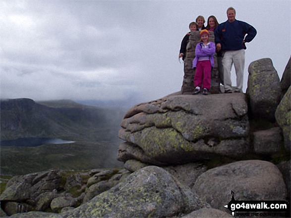 The summit of Lochnagar (Cac Carn Beag) in The East Mounth - Glen Shee and Mount Keen to Montrose
Photo: Garry Mitchell
Is there a Mountain, Peak, Top or Hill missing from the above google map or list?


