   |
Vital Statistics:
| Length: | 10mls (16km) |
| Ascent: | 1,237ft (377m) |
| Time: | 4hrs |
| Grade: |  |
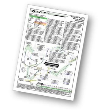
Route outline for walk ws166:
Slindon - Park Pale - Slindon Woods - The Reeds - Nore Hill - The Folly (Nore Folly) - Court Hill Farm - Down's Barn - Little Down. Dale Park House - Madehurst - Fairmile Bottom - Rewell Hill - Reweel Hill - Madehurst Wood - Slindon
Peaks, Summits and Tops reached on this walk:
 0 English Mountains |
 0 Wainwrights |
 0 English Nuttalls |
 0 English Deweys |
 0 Wainwright Outlying Fells |
 0 Marilyns |
 1 Bridget |
Peak Bagging Statistics for this walk:
The highest point of this walk is The Folly (Nore Folly) at 112m (368ft). The Folly (Nore Folly) is known as an English Bridget. The summit of The Folly (Nore Folly) is marked by an Ordnance Survey Trig Point & a ruined folly.
You can find this walk and other nearby walks on these unique free-to-access Interactive Walk Planning Maps:
1:25,000 scale OS Explorer Map (orange/yellow covers):
1:50,000 scale OS Landranger Map (pink/magenta covers):
Send us your photographs and pictures from your walks and hikes
We would love to see your photographs and pictures from walk ws166 Nore Folly and Fairmile Bottom from Slindon. Send them in to us as email attachments (configured for any computer) along with your name and where the picture was taken to:
and we shall do our best to publish them.
(Guide Resolution = 300dpi. At least = 660 pixels (wide) x 440 pixels (high).)

You can also submit photos from walk ws166 Nore Folly and Fairmile Bottom from Slindon via our Facebook Page.
NB. Please indicate where each photo was taken.


