   |
Vital Statistics:
| Length: | 4¾mls (7.5km) |
| Ascent: | 916ft (279m) |
| Time: | 2¾hrs |
| Grade: |  |
Route outline for walk dn128:
Cwm Sian Llwyd - Foel Cwm-Sian Llwyd - Trwyn Swch - Nant Llwyn-gwerh - Nant Ceunant-bach - Milltir Gerrig - Pont Cwm Pydew - Nant Cwm Pydew - Cwm Sian Llwyd
Peaks, Summits and Tops reached on this walk:
 1 Welsh Mountain |
 0 Wainwrights |
 1 Welsh Nuttall |
 0 Welsh Deweys |
 0 Wainwright Outlying Fells |
 0 Welsh Marilyns |
 0 Bridgets |
Peak Bagging Statistics for this walk:
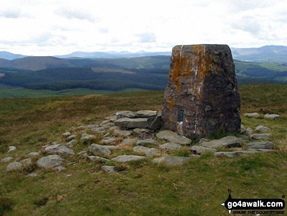
The highest point of this walk is Foel Cwm-Sian Llwyd at 648m (2127ft). Foel Cwm-Sian Llwyd is classified as a Welsh Mountain (Hewitt) (104th highest in Wales, 251st highest in England & Wales)
Foel Cwm-Sian Llwyd is also known as a Welsh Nuttall (141st highest in Wales, 335th highest in England & Wales). The summit of Foel Cwm-Sian Llwyd is marked by an Ordnance Survey Trig Point.
You can find this walk and other nearby walks on these unique free-to-access Interactive Walk Planning Maps:
1:25,000 scale OS Explorer Map (orange/yellow covers):
1:50,000 scale OS Landranger Map (pink/magenta covers):
Some Photos and Pictures from Walk dn128 Foel Cwm-Sian Llwyd from Cwm Sian Llwyd
In no particular order . . .
Send us your photographs and pictures from your walks and hikes
We would love to see your photographs and pictures from walk dn128 Foel Cwm-Sian Llwyd from Cwm Sian Llwyd. Send them in to us as email attachments (configured for any computer) along with your name and where the picture was taken to:
and we shall do our best to publish them.
(Guide Resolution = 300dpi. At least = 660 pixels (wide) x 440 pixels (high).)

You can also submit photos from walk dn128 Foel Cwm-Sian Llwyd from Cwm Sian Llwyd via our Facebook Page.
NB. Please indicate where each photo was taken.


