   |
Vital Statistics:
| Length: | 8½mls (13.5km) |
| Ascent: | 4,378ft (1,334m) |
| Time: | 7½hrs |
| Grade: |  |
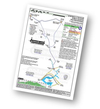
Route outline for walk ab192:
B8077 - Allt Mhoille - Castles Farm - Allt Lairig Lanachan - Glen Noe - Beinn a' Chochuill - Beinn Eunaich - Stob Maol - Castles Farm - B8077
Peaks, Summits and Tops reached on this walk:
 2 Munros |
 0 Corbetts |
 0 Grahams |
 2 Murdos |
 0 Donalds |
 2 Scottish Marilyns |
 0 Bridgets |
Peak Bagging Statistics for this walk:
The highest point of this walk is Beinn Eunaich at 989m (3246ft). Beinn Eunaich is classified as a Munro (No. 156) and a Scottish Marilyn (123rd highest in Scotland, 126th highest in the UK). Beinn Eunaich is also known as a Murdo (222nd highest in Scotland).
Completing this walk will also take you to the top of Beinn a' Chochuill at 980m (3216ft). Beinn a' Chochuill is classified as a Munro (No. 173) and a Scottish Marilyn (133rd highest in Scotland, 136th highest in the UK). Beinn a' Chochuill is also known as a Murdo (244th highest in Scotland).
You can find this walk and other nearby walks on these unique free-to-access Interactive Walk Planning Maps:
1:25,000 scale OS Explorer Map (orange/yellow covers):
1:50,000 scale OS Landranger Map (pink/magenta covers):
Send us your photographs and pictures from your walks and hikes
We would love to see your photographs and pictures from walk ab192 Beinn a' Chochuill and Beinn Eunaich from Stonmilcham. Send them in to us as email attachments (configured for any computer) along with your name and where the picture was taken to:
and we shall do our best to publish them.
(Guide Resolution = 300dpi. At least = 660 pixels (wide) x 440 pixels (high).)

You can also submit photos from walk ab192 Beinn a' Chochuill and Beinn Eunaich from Stonmilcham via our Facebook Page.
NB. Please indicate where each photo was taken.


