One easy to follow pub walk from The Old Farm Inn, Totternhoe, Bedfordshire, England
To reach The Old Farm Inn, Totternhoe, in-car SatNav users should select the Latitude/Longitude (Lat Lon) screen and enter:
Lat = N51.87990 and Lon = W 0.563
Tap/mouse over a coloured circle (1-3 easy walks, 4-6 moderate walks, 7-9 hard walks) and click to select.
Tap/mouse over a coloured circle (1-3 easy walks, 4-6 moderate walks, 7-9 hard walks) and click to select.
One easy to follow pub walk from The Old Farm Inn, Totternhoe, Bedfordshire, England
Scroll down the list of walks below & click on each walk title (in blue) to locate it on the map above.
   |
Vital Statistics:
| Length: | 6.5 miles (10.5 km) |
| Ascent: | 637ft (194m) |
| Time: | 3 hrs |
| Grade: |  |
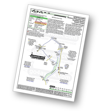
Route Summary:
Dunstable Downs Visitors Centre - The Icknield Way - Five Knolls - Drovers Way - Totternhoe - Well Head - Bison Hill - Dunstable Downs Visitors Centre


