Two easy to follow pub walks from The Hinton Arms, New Cheriton, The South Downs, Hampshire, England
To reach The Hinton Arms, New Cheriton, in-car SatNav users should select the Latitude/Longitude (Lat Lon) screen and enter:
Lat = N51.04710 and Lon = W 1.1591
Tap/mouse over a coloured circle (1-3 easy walks, 4-6 moderate walks, 7-9 hard walks) and click to select.
Tap/mouse over a coloured circle (1-3 easy walks, 4-6 moderate walks, 7-9 hard walks) and click to select.
Two easy to follow pub walks from The Hinton Arms, New Cheriton, The South Downs, Hampshire, England
Scroll down the list of walks below & click on each walk title (in blue) to locate it on the map above.
   |
Vital Statistics:
| Length: | 5 miles (8 km) |
| Ascent: | 387ft (118m) |
| Time: | 2.25hrs |
| Grade: |  |
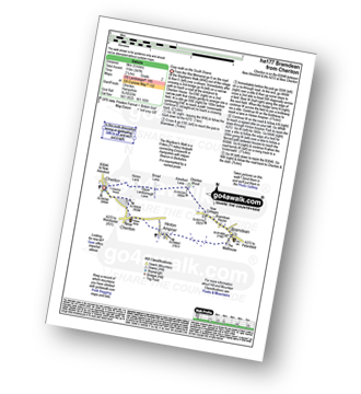
Route Summary:
Cheriton - The Wayfarer's Walk - Hinton Lane - Upper Lamborough Lane - Broad Lane - Cheriton Wood - Alresford Lane - New Cottages - Bramdean House - Bramdean - Hinton Ampner - New Cheriton - Cheriton
|
Vital Statistics:
| Length: | 7.75 miles (12.5 km) |
| Ascent: | 610ft (186m) |
| Time: | 3½ hrs |
| Grade: |  |
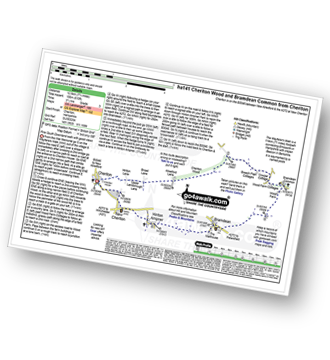
Route Summary:
Cheriton - The Wayfarer's Walk - Hinton Lane - Upper Lamborough Lane - Broad Lane - Cheriton Wood - Alresford Lane - Copwer Cottage - Bramdean Common - Wood Farm - Bramdean - Hinton Ampner - New Cheriton - Cheriton


