Two easy to follow pub walks from The Jack and Jill, Clayton, The South Downs, West Sussex, England
To reach The Jack and Jill, Clayton, in-car SatNav users should select the Latitude/Longitude (Lat Lon) screen and enter:
Lat = N50.91303 and Lon = W 0.15448
Tap/mouse over a coloured circle (1-3 easy walks, 4-6 moderate walks, 7-9 hard walks) and click to select.
Tap/mouse over a coloured circle (1-3 easy walks, 4-6 moderate walks, 7-9 hard walks) and click to select.
Two easy to follow pub walks from The Jack and Jill, Clayton, The South Downs, West Sussex, England
Scroll down the list of walks below & click on each walk title (in blue) to locate it on the map above.
   |
Vital Statistics:
| Length: | 4.5 miles (7 km) |
| Ascent: | 754ft (230m) |
| Time: | 2½ hrs |
| Grade: |  |
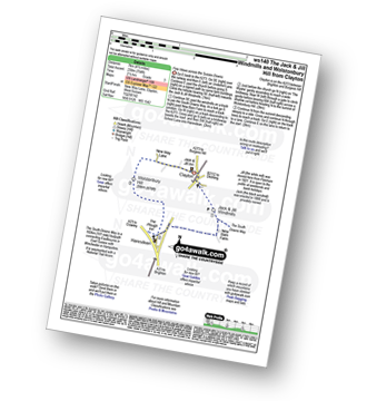
Route Summary:
Clayton - Clayton Windmills - Jill Windmill - Jack Windmill - The South Downs Way - New Barn Farm - Haresdean - Wolstonbury Hill - Clayton
|
Vital Statistics:
| Length: | 9 miles (14.5 km) |
| Ascent: | 1,594ft (486m) |
| Time: | 5 hrs |
| Grade: |  |
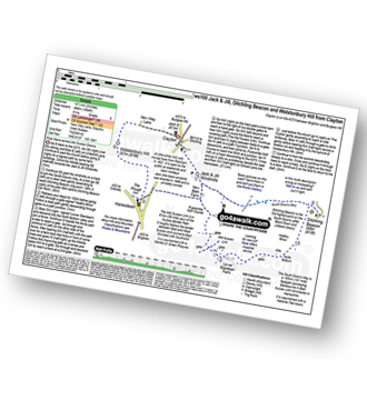
Route Summary:
Clayton - Clayton Windmills - Jill Windmill - Jack Windmill - The South Downs Way - Ditchling Beacon - Heathy Brow - North Bottom - Lower Standean Farm - New Barn Farm - The South Downs Way - Haresdean - Wolstonbury Hill - Clayton


