One easy to follow pub walk from The White Horse, Cilcain, Flintshire, Wales
To reach The White Horse, Cilcain, in-car SatNav users should select the Latitude/Longitude (Lat Lon) screen and enter:
Lat = N53.17749 and Lon = W 3.23249
Tap/mouse over a coloured circle (1-3 easy walks, 4-6 moderate walks, 7-9 hard walks) and click to select.
Tap/mouse over a coloured circle (1-3 easy walks, 4-6 moderate walks, 7-9 hard walks) and click to select.
One easy to follow pub walk from The White Horse, Cilcain, Flintshire, Wales
Scroll down the list of walks below & click on each walk title (in blue) to locate it on the map above.
   |
Vital Statistics:
| Length: | 8.25 miles (13 km) |
| Ascent: | 1,943ft (592m) |
| Time: | 5 hrs |
| Grade: |  |
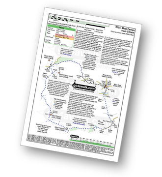
Route Summary:
Cilcain - Y Pentre - Crug Farm - Ffrith - Bryn Fynnon - Moel Famau Country Park - Moel Famau - The Offa's Dyke Path - Moel Dywyll - Moel Llys-y-coed - Bwlch Arthur - Gronfoel Farm - Cilcain


