Two easy to follow pub walks from The Dog in the Lane, Upper Astley, Shropshire, England
To reach The Dog in the Lane, Upper Astley, in-car SatNav users should select the Latitude/Longitude (Lat Lon) screen and enter:
Lat = N52.75839 and Lon = W 2.69471
Tap/mouse over a coloured circle (1-3 easy walks, 4-6 moderate walks, 7-9 hard walks) and click to select.
Tap/mouse over a coloured circle (1-3 easy walks, 4-6 moderate walks, 7-9 hard walks) and click to select.
Two easy to follow pub walks from The Dog in the Lane, Upper Astley, Shropshire, England
Scroll down the list of walks below & click on each walk title (in blue) to locate it on the map above.
   |
Vital Statistics:
| Length: | 5 miles (8 km) |
| Ascent: | 161ft (49m) |
| Time: | 2 hrs |
| Grade: |  |
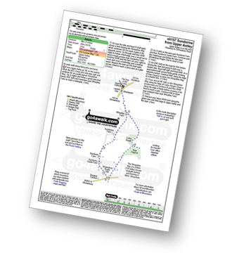
Route Summary:
Upper Astley - The Shropshire Way - Wheatley Farm - Sunderton Farm - Sundorne Farm - Sundorne Castle Farm - Shrewsbury Rugby Club - New Coppice - Colin's Rough - Wheatley Farm - Upper Astley
|
Vital Statistics:
| Length: | 7.5 miles (12 km) |
| Ascent: | 361ft (110m) |
| Time: | 3 hrs |
| Grade: |  |
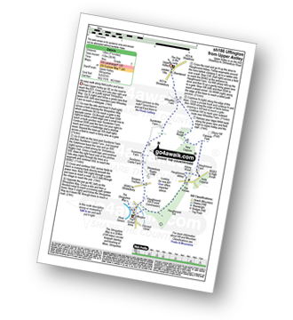
Route Summary:
Upper Astley - The Shropshire Way - Wheatley Farm - Sunderton Farm - Sundorne Farm - Sundorne Castle Farm - The River Severn - Uffington - Haughmond Hill (Forest Commisison) - The Hollies - Haughmond Abbey - Abbey Wood - Haughmond Farm - New Coppice - Colins Rough - Wheatley Farm - Upper Astley


