One easy to follow pub walk from The River and Rail Country Inn, Hampton Loade, Shropshire, England
To reach The River and Rail Country Inn, Hampton Loade, in-car SatNav users should select the Latitude/Longitude (Lat Lon) screen and enter:
Lat = N52.47320 and Lon = W 2.37221
Tap/mouse over a coloured circle (1-3 easy walks, 4-6 moderate walks, 7-9 hard walks) and click to select.
Tap/mouse over a coloured circle (1-3 easy walks, 4-6 moderate walks, 7-9 hard walks) and click to select.
One easy to follow pub walk from The River and Rail Country Inn, Hampton Loade, Shropshire, England
Scroll down the list of walks below & click on each walk title (in blue) to locate it on the map above.
   |
Vital Statistics:
| Length: | 5.25 miles (8.5 km) |
| Ascent: | 532ft (162m) |
| Time: | 2½ hrs |
| Grade: |  |
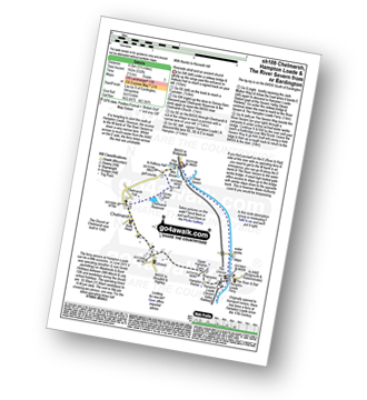
Route Summary:
Eardington - Dinney Barn - The Jack Mytton Way - Chelmarsh Reservoir - Chelmarsh - Hampton - The Jack Mytton Way - The Severn Valley Railway - Hampton Loade - The Hampton Loade Ferry - The River Severn - The Severn Way - Eardington


