One easy to follow pub walk from The Legh Arms, Prestbury, Cheshire, England
To reach The Legh Arms, Prestbury, in-car SatNav users should select the Latitude/Longitude (Lat Lon) screen and enter:
Lat = N53.28916 and Lon = W 2.15164
Tap/mouse over a coloured circle (1-3 easy walks, 4-6 moderate walks, 7-9 hard walks) and click to select.
Tap/mouse over a coloured circle (1-3 easy walks, 4-6 moderate walks, 7-9 hard walks) and click to select.
One easy to follow pub walk from The Legh Arms, Prestbury, Cheshire, England
Scroll down the list of walks below & click on each walk title (in blue) to locate it on the map above.
   |
Vital Statistics:
| Length: | 4 miles (6.5 km) |
| Ascent: | 272ft (83m) |
| Time: | 1.75hrs |
| Grade: |  |
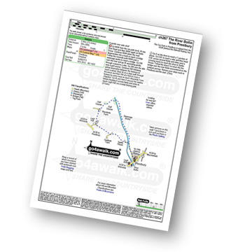
Route Summary:
Prestbury - The River Bollin - The North Cheshire Way - Woodside Farm - Legh Hall - Woodend Farm - Spittle House - Prestbury


