One easy to follow pub walk from The Cat and Fiddle, A537 Goyt's Moss, Cheshire, England
To reach The Cat and Fiddle, A537 Goyt's Moss, in-car SatNav users should select the Latitude/Longitude (Lat Lon) screen and enter:
Lat = N53.24417 and Lon = W 1.99965
Tap/mouse over a coloured circle (1-3 easy walks, 4-6 moderate walks, 7-9 hard walks) and click to select.
Tap/mouse over a coloured circle (1-3 easy walks, 4-6 moderate walks, 7-9 hard walks) and click to select.
One easy to follow pub walk from The Cat and Fiddle, A537 Goyt's Moss, Cheshire, England
Scroll down the list of walks below & click on each walk title (in blue) to locate it on the map above.
   |
Vital Statistics:
| Length: | 8.25 miles (13 km) |
| Ascent: | 1,247ft (380m) |
| Time: | 4.25hrs |
| Grade: |  |
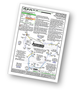
Route Summary:
Cat and Fiddle - A537 Goyt's Moss - Whetstone Ridge - Danebower Hollow - A54 - Danebower Quarries - The River Dane - The Dane Valley Way - Orchard Farm - Three Shires Head - Panniers Pool - Cheeks Hill - Dane Head - Axe Edge (Axe Edge Moor) - A54 - Cat and Fiddle


