One easy to follow pub walk from The Old Kings Head, Gurnett, Cheshire, England
To reach The Old Kings Head, Gurnett, in-car SatNav users should select the Latitude/Longitude (Lat Lon) screen and enter:
Lat = N53.24320 and Lon = W 2.11449
Tap/mouse over a coloured circle (1-3 easy walks, 4-6 moderate walks, 7-9 hard walks) and click to select.
Tap/mouse over a coloured circle (1-3 easy walks, 4-6 moderate walks, 7-9 hard walks) and click to select.
One easy to follow pub walk from The Old Kings Head, Gurnett, Cheshire, England
Scroll down the list of walks below & click on each walk title (in blue) to locate it on the map above.
   |
Vital Statistics:
| Length: | 4.5 miles (7 km) |
| Ascent: | 266ft (81m) |
| Time: | 2 hrs |
| Grade: |  |
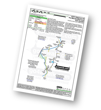
Route Summary:
Gurnett - The Macclesfield Canal - The Cheshire Ring Canal Walk - Oakgrove - Sutton Reservoir - Sutton Grange - Gurnett


