Three easy to follow pub walks from The Bulls Head, Lymm, Cheshire, England
To reach The Bulls Head, Lymm, in-car SatNav users should select the Latitude/Longitude (Lat Lon) screen and enter:
Lat = N53.38166 and Lon = W 2.47724
Tap/mouse over a coloured circle (1-3 easy walks, 4-6 moderate walks, 7-9 hard walks) and click to select.
Tap/mouse over a coloured circle (1-3 easy walks, 4-6 moderate walks, 7-9 hard walks) and click to select.
Three easy to follow pub walks from The Bulls Head, Lymm, Cheshire, England
Scroll down the list of walks below & click on each walk title (in blue) to locate it on the map above.
   |
Vital Statistics:
| Length: | 3.75 miles (6 km) |
| Ascent: | 204ft (62m) |
| Time: | 2 hrs |
| Grade: |  |
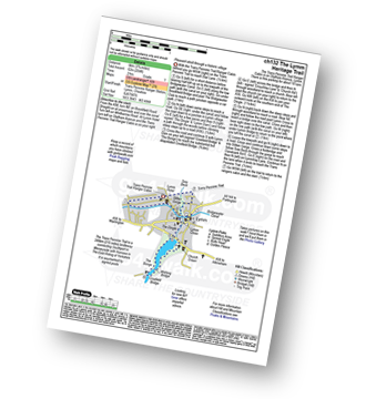
Route Summary:
The Trans Pennine Trail (Lymm) - Lymm - The Bridgewater Canal - The Cheshire Ring Canal Walk - Lymm Village - The Dingle - Lymm Dam - The Bongs - Crosfield Bridge - Lymm Dam - The Dingle - Lymm Cross - The Bridgewater Canal - The Cheshire Ring Canal Walk - Slitten Gorge - The Trans Pennine Trail - Lymm.
|
Vital Statistics:
| Length: | 5.25 miles (8.5 km) |
| Ascent: | 246ft (75m) |
| Time: | 2.25hrs |
| Grade: |  |
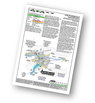
Route Summary:
The Trans Pennine Trail (Lymm) - Lymm - The Bridgewater Canal - The Cheshire Ring Canal Walk - Lymm Village - The Dingle - Lymm Dam - The Bongs - Crosfield Bridge - Oughtrington - The Bridgewater Canal - The Cheshire Ring Canal Walk - Rushgreen - Slitten Gorge - The Trans Pennine Trail - Lymm.
|
Vital Statistics:
| Length: | 11 miles (17.5 km) |
| Ascent: | 269ft (82m) |
| Time: | 4½ hrs |
| Grade: |  |
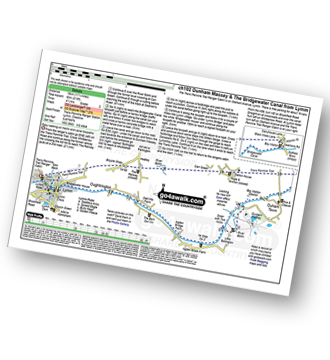
Route Summary:
The Trans Pennine Trail (Lymm) - Lymm - Carr Green - Oldfield Brow - Altrincham - The Bridgewater Canal - The Cheshire Ring Canal Walk - Dunham Town - Dunham Massey - Little Bollington - The Bridgewater Canal - The Cheshire Ring Canal Walk - Agden Bridge - Oughtrington - Lymm Village - Slitten Gorge - The Trans Pennine Trail - Lymm.


