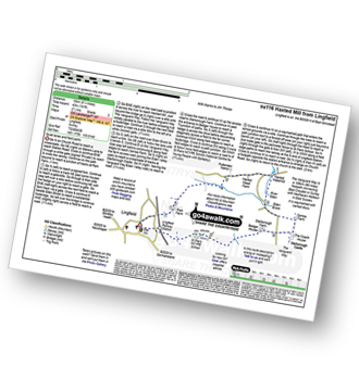
One easy to follow pub walk from The Star Inn, Lingfield, Surrey, England
To reach The Star Inn, Lingfield, in-car SatNav users should select the Latitude/Longitude (Lat Lon) screen and enter:
Lat = N51.17565 and Lon = W 0.01353
Tap/mouse over a coloured circle (1-3 easy walks, 4-6 moderate walks, 7-9 hard walks) and click to select.
Tap/mouse over a coloured circle (1-3 easy walks, 4-6 moderate walks, 7-9 hard walks) and click to select.
One easy to follow pub walk from The Star Inn, Lingfield, Surrey, England
Scroll down the list of walks below & click on each walk title (in blue) to locate it on the map above.
   |
Vital Statistics:
| Length: | 6.25 miles (10 km) |
| Ascent: | 141ft (43m) |
| Time: | 2½ hrs |
| Grade: |  |