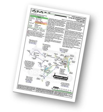
Nine easy to follow walk route maps from the busy town of Wooler in the Northumberland National Park, Northumberland, England
Scroll down the list of walks below & click on each walk title (in blue) to locate it on the map above.
   |
Vital Statistics:
| Length: | 6.5 miles (10.5 km) |
| Ascent: | 240ft (73m) |
| Time: | 2.75hrs |
| Grade: |  |
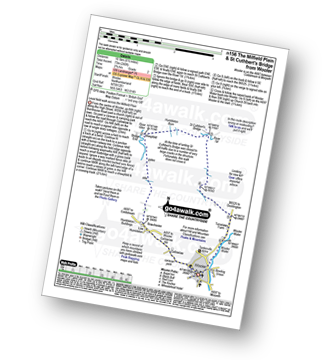
Route Summary:
Wooler - Gallowlaw Gallowlaw Hill - Low Humbleton - Bowchester - The River Glen - Bridge End - Humbleton Burn Milfield Plain - St Cuthbert's Bridge - Turvelaws Farm - Wooler
|
Vital Statistics:
| Length: | 3.25 miles (5 km) |
| Ascent: | 525ft (160m) |
| Time: | 1.75hrs |
| Grade: | |
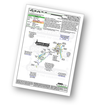
Route Summary:
Wooler - The St Cuthbert's Way - Waud House - Kenterdale Hill - Wooler Common and Woodland Park - Wooler
|
Vital Statistics:
| Length: | 4.75 miles (7.5 km) |
| Ascent: | 985ft (300m) |
| Time: | 2.75hrs |
| Grade: |  |
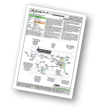
Route Summary:
Wooler - Gallowlaw Gallowlaw Hill - Humbleton - Humbleton Hill - Brown's Law - Wooler Common And Woodland Park - Wooler
|
Vital Statistics:
| Length: | 8.5 miles (13.5 km) |
| Ascent: | 1,093ft (333m) |
| Time: | 4.25hrs |
| Grade: |  |
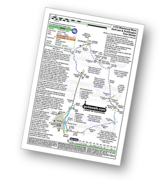
Route Summary:
Wooler - The St Cuthbert's Way - Weetwood Bank - Weetwood Moor - River Till - Weetwood Bridge - Weetwood Hall - Weetwood Hill - Broomy Knowe - Shepherds House - Dod Law - Doddington Moor - Doddington - Milfield Plain - Doddington Bridge - Turvelaws Farm - Wooler
|
Vital Statistics:
| Length: | 5.75 miles (9 km) |
| Ascent: | 1,214ft (370m) |
| Time: | 3½ hrs |
| Grade: | |
Route Summary:
Wooler - Gallowlaw Gallowlaw Hill - Humbleton - Humbleton Hill - Brown's Law - Wooler Common and Woodland Park - The St Cuthbert's Way - Kenterdale Hill - Waud House - Wooler
|
Vital Statistics:
| Length: | 6.5 miles (10.5 km) |
| Ascent: | 1,043ft (318m) |
| Time: | 3½ hrs |
| Grade: | |
Route Summary:
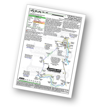
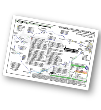
Wooler - The St Cuthbert's Way - Waud House - Kenterdale Hill - Wooler Common - Switcher Wood - Earlhillhead Farm - Carey Burn - Careyburn Bridge - Harthope Burn - Colgate Water (Low Level Route) - Skirl Naked - Grimping Haugh - Broom Crook Plantation - Happy Valley - Careyburn Bridge - Colgate Mill - Earle Mill - Wooler Water - Wooler
|
Vital Statistics:
| Length: | 7.5 miles (12 km) |
| Ascent: | 1,257ft (383m) |
| Time: | 4½ hrs |
| Grade: |  |
Route Summary:
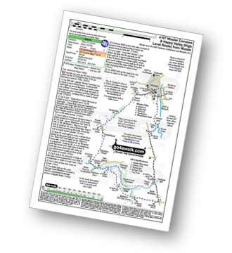
Wooler - The St Cuthbert's Way - Waud House - Kenterdale Hill - Wooler Common - Switcher Wood - Earlhillhead Farm - Carey Burn - Careyburn Bridge - Harthope Burn - Colgate Water (High Level Route) - Happy Valley - Middleton Old Town - North Middleton - Colgate Mill - Colgate Water - Earle Mill - Wooler Water - Wooler
|
Vital Statistics:
| Length: | 10.25 miles (16.5 km) |
| Ascent: | 1,182ft (360m) |
| Time: | 5 hrs |
| Grade: | |
Route Summary:
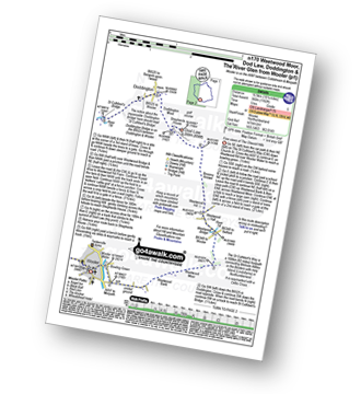
Wooler - The St Cuthbert's Way - Weetwood Bank - Weetwood Moor - River Till - Weetwood Bridge - Weetwood Hall - Weetwood Hill - Broomy Knowe - Shepherds House - Dod Law (Doddington Moor) - Doddington Moor - Doddington - River Till - St Cuthbert's Bridge - Milfield Plain - River Glen - Bridge End - Bowchester - Low Humbleton - Gallowlaw Hill - Gallowlaw - Wooler
|
Vital Statistics:
| Length: | 10.75 miles (17 km) |
| Ascent: | 1,746ft (532m) |
| Time: | 5.75hrs |
| Grade: |  |
Route Summary:
Wooler - The St Cuthbert's Way - Waud House - Kenterdale Hill - Wooler Common - Carey Burn - Broadstruthers Burn - Commonburn House - Wackerage Cairn - Tom Tallon's Crag - The St Cuthbert's Way - Gleadscleugh - Akeld Burn - Humbleton - Gallowlaw - Wooler

To contribute to go4awalk.com or to contact us about anything at all - see Talk To Us. For help see Help.
go4awalk.com and go4awalk.co.uk are registered trademarks of TMDH Limited.
Copyright © 2000-2025 TMDH Limited. All rights reserved.
Copyright Terms & Conditions Privacy Statement
A - Z Walks Home Log On/Accounts Photo Gallery Walk Ideas and Collections Fell Facts Hill Skills Walking Questions and Answers Your Stories News Competitions Product Reviews/Gear Tests Walking Gear Guides Peaks and Mountains Peak Bagging Find New Walking Friends Camping GPS Waypoints for Walking Contents Walk Search Talk To Us go4awalk.com Help Free Example Walks Newsletter


