Walks Routes Maps from Tissington in The White Peak Area, The Peak District, Derbyshire in Walk Grade Order
Route maps for Walks that start, or go through, Tissington in The White Peak Area, The Peak District, Derbyshire, England in Walk Grade Order
Details of refreshments, pubs & parking are included on each Tissington walk description.
   |
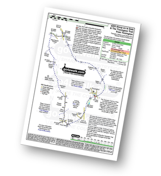
Vital Statistics:
| Length: | 4 miles (6.5 km) |
| Ascent: | 508ft (155m) |
| Time: | 2 hrs |
| Grade: |  |
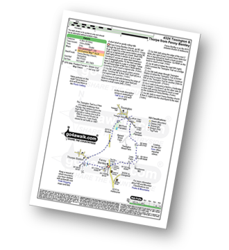
Route Summary:
Fenny Bentley - Lees Farm - Darfield Plantation - Tissington - The Tissington Trail - Thorpe Station - Fenny Bentley
|
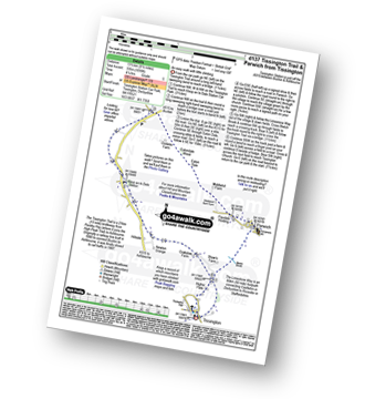
Vital Statistics:
| Length: | 9.75 miles (15.5 km) |
| Ascent: | 735ft (224m) |
| Time: | 5.25hrs |
| Grade: |  |
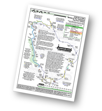
Route Summary:
Thorpe - The Tissington Trail - Lin Dale - Dove Dale - The River Dove - Stepping Stones - Lover's Leap - Tissington Spires - Shaplow Dale - Dove Holes - Milldale - Mill Dale - Alsop en le Dale - The Tissington Trail - Tissington - Thorpe
|
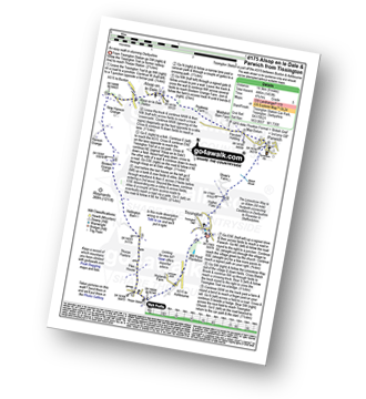
Vital Statistics:
| Length: | 7.25 miles (12.5 km) |
| Ascent: | 1,007ft (307m) |
| Time: | 4 hrs |
| Grade: | |
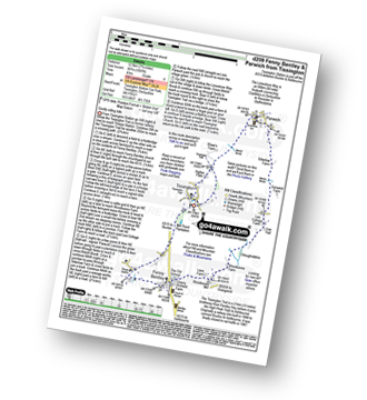
Route Summary:
Tissington - The Tissington Trail - Thorpe Station - Fenny Bentley - Woodeaves Mill - Woodeaves Farm - Lea Hall - Lee Cottage Farm - Bletch Book - Sittlerlow Farm - Parwich - The Limestone Way - Bletch Brook - The Tissington Trail - Tissington
|
Vital Statistics:
| Length: | 6.25 miles (10 km) |
| Ascent: | 941ft (287m) |
| Time: | 3.25hrs |
| Grade: | |
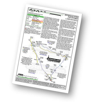
Route Summary:
Tissington - Newton Grange - The Tissington Trail - Alsop en le Dale Station - Alsop en le Dale - Flaxdale Holding - Parwich - Bletch Brook - Higher Flats - Tissington
|
Vital Statistics:
| Length: | 7.25 miles (12.5 km) |
| Ascent: | 1,056ft (322m) |
| Time: | 3.75hrs |
| Grade: | |
Route Summary:
Tissington - The Tissington Trail - Thorpe Station - Thorpe - Pike House - Thorpe Pasture - Bostern Grange Farm - Alsop en le Dale Station - Tissington
|
Vital Statistics:
| Length: | 8.5 miles (13.5 km) |
| Ascent: | 1,099ft (335m) |
| Time: | 4.25hrs |
| Grade: |  |
Route Summary:
Tissington - The Tissington Trail - Alsop en le Dale Station - Oxdales Farm - Eaton Dale - Eatondale Wood - Flaxdale Holding - Parwich - Bletch Brook - Higher Flats - Tissington
|
Vital Statistics:
| Length: | 9 miles (14.5 km) |
| Ascent: | 1,453ft (446m) |
| Time: | 4.75hrs |
| Grade: | |
Route Summary:
Tissington - The Tissington Trail - Thorpe Station - Thorpe - Pike House - Thorpe Pasture - Bostern Grange Farm - Alsop en le Dale Station - Parwich - The Limestone Way - Tissington
|
Vital Statistics:
| Length: | 15.5 miles (24.5 km) |
| Ascent: | 1,742ft (531m) |
| Time: | 7.25hrs |
| Grade: |  |
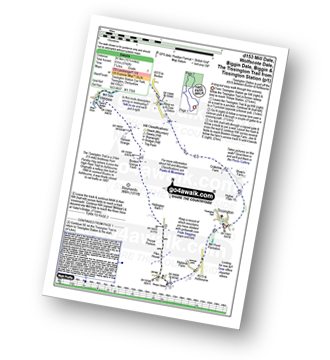
Route Summary:
Tissington - The Tissington Trail - Thorpe Station - Thorpe - Pike House - Thorpe Pasture - Bostern Grange Farm - Milldale - River Dove - Mill Dale - Lode Mill Bridge - Coldeaton Bridge - Wolfscote Dale - Biggin Dale - Biggin - The Tissington Trail - Alsop en le Dale Station - Tissington
See more easy-to-follow circular walks in The Peak District
See more easy-to-follow circular walks in Derbyshire


