Walks Routes Maps from Maggie's Bridge (Loweswater) in The Western Fells, The Lake District, Cumbria in Walk Grade Order
Route maps for Walks that start, or go through, Maggie's Bridge (Loweswater) in The Western Fells, The Lake District, Cumbria, England in Walk Grade Order
Details of refreshments, pubs & parking are included on each Maggie's Bridge (Loweswater) walk description.
   |
Vital Statistics:
| Length: | 4.25 miles (6.5 km) |
| Ascent: | 98ft (30m) |
| Time: | 1½ hrs |
| Grade: |  |
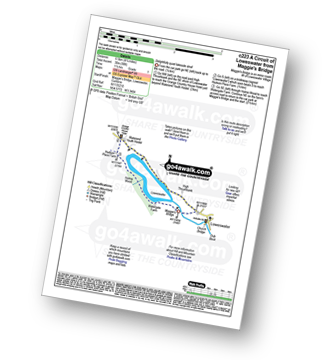
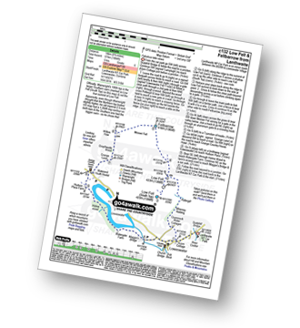
Route Summary:
Maggie's Bridge (Loweswater) - High Thrushbank - Loweswater - Waterend Youth Hostel - Hudson Place Farm - Holme Wood - Watergate Farm - Maggie's Bridge (Loweswater)
|
Vital Statistics:
| Length: | 7 miles (11 km) |
| Ascent: | 1,726ft (526m) |
| Time: | 4.25hrs |
| Grade: |  |
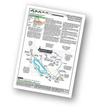
Route Summary:
Maggie's Bridge (Loweswater) - Acorn Cottage - Crummockwater Cottages and Foulsyke - Pottergill - Raven Crag (Low Fell) - Low Fell - Low Fell (South Top) - Crabtree Beck - Darling Fell - Loweswater - Waterend Youth Hostel - Hudson Place Farm - Holme Wood - Watergate Farm - Maggie's Bridge (Loweswater)
|
Vital Statistics:
| Length: | 7.75 miles (12.5 km) |
| Ascent: | 1,923ft (586m) |
| Time: | 4.75hrs |
| Grade: | |
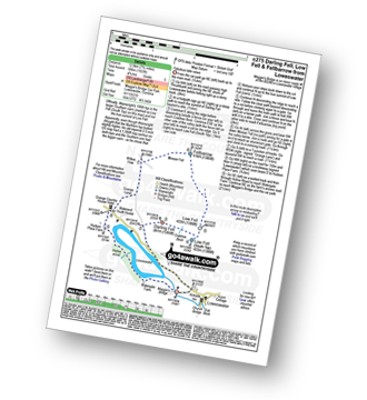
Route Summary:
Maggie's Bridge (Loweswater) - Loweswater - Darling Fell - Crabtree Beck - Low Fell (South Top) - Low Fell - Fellbarrow - Mosser Fell - Wilkes How - Waterend Youth Hostel - Hudson Place Farm - Holme Wood - Watergate Farm - Maggie's Bridge (Loweswater)
|
Vital Statistics:
| Length: | 6.5 miles (10.5 km) |
| Ascent: | 2,025ft (617m) |
| Time: | 4½ hrs |
| Grade: | |
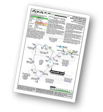
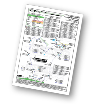
Route Summary:
Maggie's Bridge (Loweswater) - Loweswater - High Nook Farm - Highnook Beck - Holme Wood - Burnbank Fell - Sharp Knott - Blake Fell - Fothergill Head - Gavel Fell - Black Crag (Gavel Fell) - Highnook Beck - Maggie's Bridge (Loweswater)
|
Vital Statistics:
| Length: | 8.75 miles (14 km) |
| Ascent: | 1,884ft (574m) |
| Time: | 5 hrs |
| Grade: |  |
Route Summary:
Lanthwaite - Acorn Cottage - Crummockwater Cottages and Foulsyke - Pottergill - Raven Crag (Low Fell) - Low Fell - Low Fell (South Top) - Fellbarrow - Mosser Fell - Wilkes How - Waterend Youth Hostel - Hudson Place Farm - Holme Wood - Watergate Farm - Maggie's Bridge (Loweswater) - Loweswater - Lanthwaite
|
Vital Statistics:
| Length: | 8.5 miles (13.5 km) |
| Ascent: | 2,540ft (774m) |
| Time: | 6 hrs |
| Grade: | |
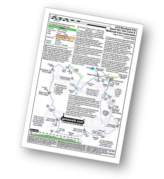
Route Summary:
Maggie's Bridge (Loweswater) - Loweswater - High Nook Farm - Highnook Beck - Holme Wood - Holme Beck - Burnbank Fell - Sharp Knott - Blake Fell - Fothergill Head - Gavel Fell - Grain Gill - Whiteoak Moss - Hen Comb - Little Dodd (Loweswater Fell) - Mosedale (Loweswater) - Mosedale Beck (Loweswater) - Loweswater Village - Maggie's Bridge (Loweswater)
|
Vital Statistics:
| Length: | 6.25 miles (10 km) |
| Ascent: | 6ft (770m) |
| Time: | 5 hrs |
| Grade: | |
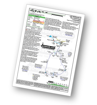
Route Summary:
Maggie's Bridge (Loweswater) - Loweswater - Kirkgate Farm - Raven Crag - White Crag - Mellbreak (North Top) - Mellbreak - Mosedale Beck (Loweswater) - Thrang Crags - Hen Comb - Little Dodd (Loweswater Fell) - Mosedale Beck (Loweswater) - Kirkgate Farm - Loweswater - Maggie's Bridge (Loweswater)
|
Vital Statistics:
| Length: | 9.5 miles (15 km) |
| Ascent: | 3,666ft (1,117m) |
| Time: | 7.25hrs |
| Grade: |  |
Route Summary:
Maggie's Bridge (Loweswater) - Loweswater - High Nook Farm - Highnook Beck - Holme Wood - Holme Beck - Burnbank Fell - Sharp Knott - Blake Fell - Fothergill Head - Gavel Fell - Grain Gill - Whiteoak Moss - Hen Comb - Thrang Crags - Mosedale (Loweswater) - Mosedale Beck (Loweswater) - Mellbreak - Mellbreak (North Top) - White Crag - Loweswater Village - Maggie's Bridge (Loweswater)
See more easy-to-follow circular walks in The Lake District
See more easy-to-follow circular walks in Cumbria


