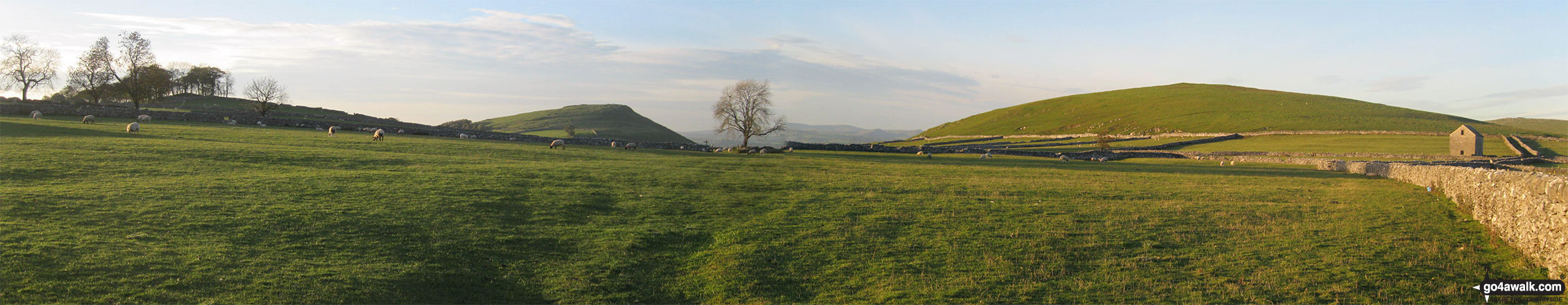
Narrowdale Hill (right) and Gratton Hill (right) from near Alstonefield
The White Peak Area,
The Peak District National Park,
Staffordshire, England
See views like this by using any of these 11 easy-to-follow circular walk route maps:
   |
Vital Statistics:
| Length: | 5.5 miles (9 km) |
| Ascent: | 426ft (130m) |
| Time: | 2½ hrs |
| Grade: |  |
Route Summary:
Alstonefield - Overdale - Coldeaton Bridge - River Dove - Coldeaton Bridge - Iron Tors - Gipsy Bank - Drabber Tor - Caves - Peasland Tor - Wolfscote Dale - Beresford Dale - Narrow Dale - The Rakes - Alstonefield
|
Vital Statistics:
| Length: | 6.75 miles (11 km) |
| Ascent: | 722ft (220m) |
| Time: | 3 hrs |
| Grade: |  |
Route Summary:
Alstonefield - Milldale - Mill Dale - Lode Mill Bridge - River Dove - Coldeaton Bridge - Iron Tors - Gipsy Bank - Drabber Tor - Caves - Peasland Tor - Wolfscote Dale - Frank-i-th-Rocks Bridge - Beresford Dale - Narrow Dale - The Rakes - Alstonefield
|
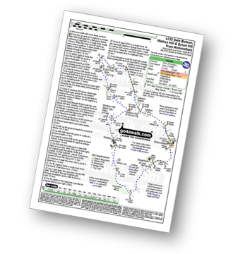
Vital Statistics:
| Length: | 8.25 miles (13 km) |
| Ascent: | 1,430ft (436m) |
| Time: | 4½ hrs |
| Grade: |  |
Route Summary:
Hartington - Crossland Sides - Pennilow - Beresford Dale - Pike Pool - How Narrowdale - The Rakes - Alstonefield - Overdale - Gipsy Bank - River Dove - Coldeaton Bridge - Iron Tors - Drabber Tor - Wolfscote Dale - Peasland Rocks - Staden Barn - Hartington
|
Vital Statistics:
| Length: | 5.5 miles (9 km) |
| Ascent: | 1,615ft (492m) |
| Time: | 3.75hrs |
| Grade: | |
Route Summary:
Alstonefield - Alstonefield Youth Hostel - Overdale - Gipsy Bank - Wolfescote Dale - Coldeaton Bridge - Mill Dale - Milldale - Dove Dale - Achas Bank - Ilam Rock - Dovedale - Hall Dale - Stanshope - Dale Bottome - Alstonefield.
|
Vital Statistics:
| Length: | 8.75 miles (14 km) |
| Ascent: | 1,473ft (449m) |
| Time: | 4.75hrs |
| Grade: |  |
Route Summary:
Hartington - Crossland Sides - Pennilow - Beresford Dale - Pike Pool - How Narrowdale - The Rakes - Alstonefield - Overdale - Gipsy Bank - River Dove - Coldeaton Bridge - Iron Tors - Drabber Tor - Wolfscote Dale - Peasland Rocks - Biggin Dale - Furny Bottom - Dale End - Biggin - Hartington
|
Vital Statistics:
| Length: | 7.25 miles (11.5 km) |
| Ascent: | 1,302ft (397m) |
| Time: | 4 hrs |
| Grade: | |
Route Summary:
Milldale - River Dove - Alstonefield - Wetton - Wetton Low - Castern Wood Nature Reserve - Damgate Farm - Hall Dale - Dove Dale - Achas Bank - Milldale
|
Vital Statistics:
| Length: | 9.75 miles (15.5 km) |
| Ascent: | 2,146ft (654m) |
| Time: | 5.75hrs |
| Grade: |  |
Route Summary:
Ilam - Ilam Country Park - River Manifold - Castern Hall - Castern Wood Nature Reserve - Wetton Low - Wetton - Alstonefield - Milldale - Achas Bank - Raven's Tor - Hall Dale - Dove Dale Wood - Air Cottage - Ilam Tops - Ilamtops Farm - Ilam
|
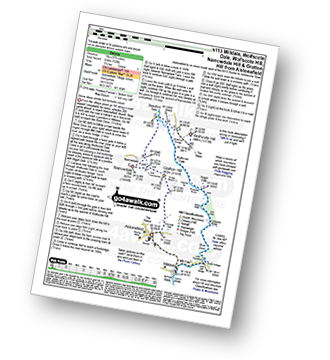
Vital Statistics:
| Length: | 11.5 miles (18.5 km) |
| Ascent: | 1,572ft (479m) |
| Time: | 5.75hrs |
| Grade: | |
Route Summary:
Milldale - Mill Dale - River Dove - Coldeaton Bridge - Gipsy Bank - Peasland Rocks - Wolfscote Dale - Frank-i-the=Ricks Bridge - Beresford Dale - Barracks Farm - Harecops - Acton Moor - Back of Ecton - Ecton Hill - Cantrell's House - Wetton Hill - Wetton Hill (West Top) - Wetton - Alstonefield - Milldale
|
Vital Statistics:
| Length: | 9.25 miles (15 km) |
| Ascent: | 1,769ft (539m) |
| Time: | 5.25hrs |
| Grade: | |
Route Summary:
Alstonefield - Dale Bottom - Hopedale - Castern Wood Nature Reserve - Wetton Low - Wetton - Wetton Hill (West Top) - Wetton Hill - Ecton Hill - Acton Moor - Gateham Grange - Gateham Farm - Steep Low - Alstonefield
|
Vital Statistics:
| Length: | 9.75 miles (15.5 km) |
| Ascent: | 1,910ft (582m) |
| Time: | 5½ hrs |
| Grade: | |
Route Summary:
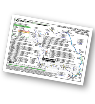
Alstonefield - Milldale - Mill Dale - Lode Mill Bridge - River Dove - Coldeaton Bridge - Iron Tors - Gipsy Bank - Drabber Tor - Caves - Peasland Tor - Wolfscote Dale - Frank-i-th-Rocks Bridge - Wolfscote Grange - Wolfscote Hill - Beresford Dale - Narrowdale Hill - Narrow Dale - Gratton Hill - The Rakes - Alstonefield
|
Vital Statistics:
| Length: | 15 miles (24 km) |
| Ascent: | 2,028ft (618m) |
| Time: | 8 hrs |
| Grade: |  |
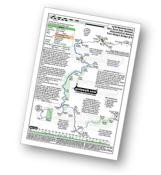
Route Summary:
Weag's Bridge - River Manifold - Beeston Tor Farm - River Hamps - Soles Coppice - Old Soles Wood - Hell Hole - Lee House - Farwell Farm - Calton - Carlton Green - Rushley Wood - Musden Wood - Rushley - Ilam Country Park - Ilam - River Dove - Dovedale Castle - Dove Dale - The River Dove - Stepping Stones - Lover's Leap - Tissington Spires - Shaplow Dale,Natural Arch - Raynard's Cave - Upper Taylor's Wood - Dove Holes - Viator's Bridge - Milldale - Alstonefield - Wetton - Thor's Cave - Weag's Bridge
Send us your photographs and pictures of walks and hikes in the British countryside
If you would like to see your digital photographs as part of this collection, please send them as email attachments (configured for any computer) along with your name to:
and we shall do our best to publish them.
(Guide Resolution = 300dpi. At least = 587 pixels (wide) x 440 pixels (high).)

You can also submit photos via our Facebook Page.
NB. Please indicate where each photo was taken.
NB. To see photographs and pictures from a particular walk choose your walk from Walks or use our Walk Search facility.
To see photographs and pictures on, of or from a particular Mountain, Peak, Top or Hill select from Peaks & Mountains' or enter the Mountain, Peak, Top or Hill Name into our 'Photo Search facility.


