
![]()
Kit Hill
334m (1096ft)
Tamar Valley, Cornwall, England
Prince Charles gave Kit Hill to the people of Cornwall in 1982 for their enjoyment to celebrate the birth of Prince William.
Tap/mouse over a coloured circle (1-3 easy walks, 4-6 moderate walks, 7-9 hard walks) and click to select.
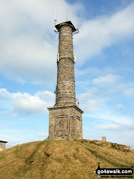
The summit of Kit Hill is marked by an Ordnance Survey Trig Point.
Not familiar with this top?
   |
|---|
Vital Statistics:
| Length: | 7.25ml (11.5km) |
|---|---|
| Ascent: | 1,260ft (384m) |
| Time: | 4 hrs |
| Grade: |  (Moderate) (Moderate) |
Route Summary:
Luckett - Treovitown Farm - New Mill Cottage - Lower Clitters House - South Kit Hill Mine - Kit Hill - Kit Hill Quarry - Downgate - Old Mill Cottage - New Mill Cottage - Luckett
A go4awalk.com downloadable Peak Bagging Map in PDF format featuring Kit Hill should be available soon.
You can find Kit Hill & all the walks that climb it on these unique free-to-access Interactive Walk Planning Maps:
1:25,000 scale OS Explorer Map (orange/yellow covers):
An Interactive Walk Planning Map for OS Explorer 108 Lower Tamar Valley & Plymouth is not currently available
1:50,000 scale OS Landranger Map (pink/magenta covers):
 Fellow go4awalkers who have already walked, climbed, summited & bagged Kit Hill
Mark Davidson walked up Kit Hill on February 28th, 2009 [with] Alone [weather] Sunny but quite cold. - Great tower on the summit
To add (or remove) your name and experiences on this page - Log On and edit your Personal Mountain Bagging Record
Send us your photographs and pictures on, of, or from Kit Hill
If you would like to add your walk photographs and pictures featuring views from, on or of Kit Hill to this page, please send them as email attachments (configured for any computer) along with your name to:
and we shall do our best to publish them.
(Guide Resolution = 300dpi. At least = 660pixels (wide) x 440 pixels (high).)

You can also submit photos via our Facebook Page.
NB. Please indicate where each photo was taken and whether you wish us to credit your photos with a Username or your First Name/Last Name.
Not familiar with this top?


