
![]()
Lindley Moor
245m (804ft)
The South Pennines and The Forest of Bowland, North Yorkshire, England
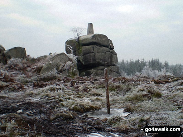
The summit of Lindley Moor is marked by an Ordnance Survey Trig Point.

Not familiar with this top?
See Lindley Moor and the surrounding tops on our free-to-access 'Google Style' Peak Bagging Map:
The Forest of Bowland and The South Pennines
Less data - quicker to download
See Lindley Moor and the surrounding tops on our downloadable Peak Bagging Map in PDF format:

NB: Whether you print off a copy or download it to your phone, this PDF Peak Baggers' Map might prove incredibly useful when your are up there on the tops and you cannot get a phone signal.
Free-to-access Interactive Walk Planning Maps:
1:25,000 scale OS Explorer Map (orange/yellow covers):
An Interactive Walk Planning Map for OS Explorer 297 Lower Wharfedale & Washburn Valley is not currently available
1:50,000 scale OS Landranger Map (pink/magenta covers):
An Interactive Walk Planning Map for OS Landranger 104 Leeds & Bradford, Harrogate & Ilkley is not currently available
 Fellow go4awalkers who have already walked, climbed, summited & bagged Lindley Moor
Patrick Rogozinski has walked, climbed & bagged Lindley Moor.
To add (or remove) your name and experiences on this page - Log On and edit your Personal Mountain Bagging Record
More Photographs & Pictures of views from, on or of Lindley Moor
Send us your photographs and pictures on, of, or from Lindley Moor
If you would like to add your walk photographs and pictures featuring views from, on or of Lindley Moor to this page, please send them as email attachments (configured for any computer) along with your name to:
and we shall do our best to publish them.
(Guide Resolution = 300dpi. At least = 660pixels (wide) x 440 pixels (high).)

You can also submit photos via our Facebook Page.
NB. Please indicate where each photo was taken and whether you wish us to credit your photos with a Username or your First Name/Last Name.
Not familiar with this top?


