
![]()
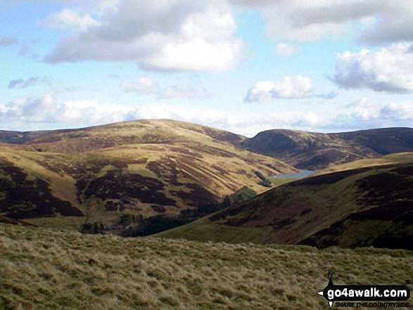
Hudderstone
626m (2055ft)
The Tinto & Culter Hills, The Scottish Borders, South Lanarkshire, Scotland
Not familiar with this top?
   |
|---|
Vital Statistics:
| Length: | 12.25ml (19.5km) |
|---|---|
| Ascent: | 3,305ft (1,007m) |
| Time: | 7.75hrs |
| Grade: |  (Hard) (Hard) |
Route Summary:
Culter Allers Farm - Culter Fell - Moss Law - Holm Nick - Gathersnow Hill - Hillshaw Head - Coomb Dod - Dod Hill - Hudderstone - Lea Gill - Culter Water - Culter Allers Farm
See Hudderstone and the surrounding tops on our free-to-access 'Google Style' Peak Bagging Maps:
The Tinto & Culter Hills area of Scottish Region 28: The Scottish Borders
Less data - quicker to download
Scottish Region 27: The Scottish Borders
Less data - quicker to download
A go4awalk.com downloadable Peak Bagging Map in PDF format featuring Hudderstone should be available soon.
Free-to-access Interactive Walk Planning Maps:
1:25,000 scale OS Explorer Map (orange/yellow covers):
An Interactive Walk Planning Map for OS Explorer 336 Biggar & Broughton is not currently available
1:50,000 scale OS Landranger Map (pink/magenta covers):
An Interactive Walk Planning Map for OS Landranger 72 Upper Clyde Valley, Biggar & Lanark is not currently available
 Fellow go4awalkers who have already walked, climbed, summited & bagged Hudderstone
Mark Davidson walked up Hudderstone on May 24th, 2018 [with] Alone [weather] Nice & bright - Lovely walk with splendid isolation
To add (or remove) your name and experiences on this page - Log On and edit your Personal Mountain Bagging Record
Send us your photographs and pictures on, of, or from Hudderstone
If you would like to add your walk photographs and pictures featuring views from, on or of Hudderstone to this page, please send them as email attachments (configured for any computer) along with your name to:
and we shall do our best to publish them.
(Guide Resolution = 300dpi. At least = 660pixels (wide) x 440 pixels (high).)

You can also submit photos via our Facebook Page.
NB. Please indicate where each photo was taken and whether you wish us to credit your photos with a Username or your First Name/Last Name.
Not familiar with this top?


